
$895
/ Month
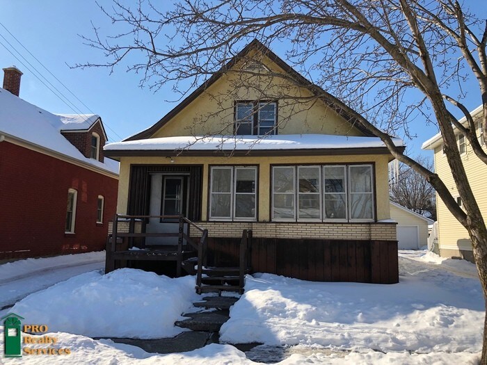
695 S Canton St Unit 2
Saint Paul, MN 55102
2 Weeks Ago
Favorites
695 S Canton St Unit 2

Favorites
Check Back Soon for Upcoming Availability
| Beds | Baths | Average SF |
|---|---|---|
| 1 Bedroom 1 Bedroom 1 Br | 1 Bath 1 Bath 1 Ba | — |
About This Property
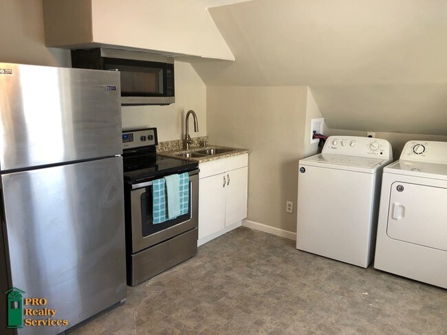
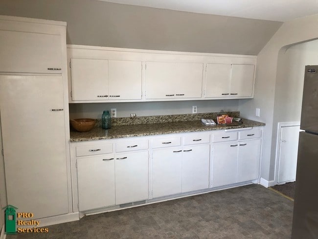
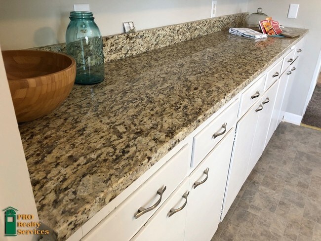
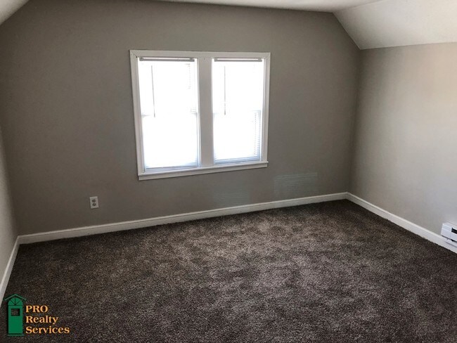
Don't pass this one up! Recently remodeled one bedroom, one bathroom upper level duplex unit! Wonderfully updated kitchen with granite countertops, and stainless steel appliances. In unit laundry, new carpet, a balcony off the kitchen, and a 2 car garage (shared) are some other great features of this property! Close to many shops and restaurants as well as Harriet Island Regional Park! Video Link: https://youtu.be/k48BaNH3Puk Utilities Paid by Resident: Gas, Electric, Water/Sewer, Trash, Telephone, Cable & Internet. Many homes for rent are currently occupied. Please respect the convenience and privacy of our residents. Showings are by appointment only. Call Darcy with PRO Realty Services today at (612) 547-9818 with questions or to schedule a showing. Qualifications: Max occupants: 2. Must have satisfactory rental history, must pass criminal history background check and must have documented income of 2.5 times the monthly rent, pet subject to approval, no recent evictions. Property is not Section 8. Please see detailed rental criteria on our application. Rental Terms: Rent: $895, Application Fee: $50, Security Deposit: $895, Available Now Contact us to schedule a showing.
695 S Canton St is an apartment community located in Ramsey County and the 55102 ZIP Code.
Location
Get Directions
Often referred to as the “West End,” West Seventh is a convenient neighborhood located on the Riverview Corridor transit system, making travel to Downtown Saint Paul, the Minneapolis-Saint Paul Airport, and the Mall of America simple for locals.
Residents of West Seventh enjoy direct access to Interstate 35E and Xcel Energy Center. There are a plethora of amenities and attractions along the Mississippi River – from parks to historic landmarks and the High Bridge Dog Park.
Many of West Seventh’s restaurants are found along 7th Street West, like Bad Weather Brewing Company, Cossetta’s, and JR Mac’s Bar & Grill. Residents adore the proximity to the airport, and Saint Paul attractions and shopping.
Learn more about living in West SeventhBelow are rent ranges for similar nearby apartments
| Beds | Average Size | Lowest | Typical | Premium |
|---|---|---|---|---|
| Studio Studio Studio | 536 Sq Ft | $881 | $1,312 | $2,671 |
| 1 Bed 1 Bed 1 Bed | 747-750 Sq Ft | $950 | $1,766 | $3,684 |
| 2 Beds 2 Beds 2 Beds | 1225-1226 Sq Ft | $1,195 | $2,569 | $6,440 |
| 3 Beds 3 Beds 3 Beds | 1596 Sq Ft | $1,599 | $3,026 | $5,070 |
| 4 Beds 4 Beds 4 Beds | 1750 Sq Ft | $2,500 | $2,598 | $2,695 |
Education
| Colleges & Universities | Distance | ||
|---|---|---|---|
| Colleges & Universities | Distance | ||
| Drive: | 7 min | 2.8 mi | |
| Drive: | 7 min | 2.9 mi | |
| Drive: | 9 min | 3.0 mi | |
| Drive: | 6 min | 3.5 mi |
695 S Canton St Unit 2 is within 7 minutes or 2.9 miles from Macalester College. It is also near Concordia Univ.-Saint Paul and Saint Paul College.
Transportation options available in Saint Paul include Victoria St Station, located 2.9 miles from 695 S Canton St Unit 2. 695 S Canton St Unit 2 is near Minneapolis-St Paul International/Wold-Chamberlain, located 6.4 miles or 11 minutes away.
| Transit / Subway | Distance | ||
|---|---|---|---|
| Transit / Subway | Distance | ||
| Drive: | 8 min | 2.9 mi | |
| Drive: | 8 min | 3.1 mi | |
| Drive: | 8 min | 3.1 mi | |
| Drive: | 9 min | 3.7 mi | |
| Drive: | 7 min | 4.1 mi |
| Commuter Rail | Distance | ||
|---|---|---|---|
| Commuter Rail | Distance | ||
|
|
Drive: | 5 min | 3.6 mi |
|
|
Drive: | 21 min | 9.9 mi |
|
|
Drive: | 27 min | 20.3 mi |
|
|
Drive: | 37 min | 28.4 mi |
|
|
Drive: | 39 min | 30.0 mi |
| Airports | Distance | ||
|---|---|---|---|
| Airports | Distance | ||
|
Minneapolis-St Paul International/Wold-Chamberlain
|
Drive: | 11 min | 6.4 mi |
Time and distance from 695 S Canton St Unit 2.
| Shopping Centers | Distance | ||
|---|---|---|---|
| Shopping Centers | Distance | ||
| Drive: | 4 min | 1.6 mi | |
| Drive: | 4 min | 1.6 mi | |
| Drive: | 5 min | 1.6 mi |
695 S Canton St Unit 2 has 3 shopping centers within 1.6 miles, which is about a 5-minute drive. The miles and minutes will be for the farthest away property.
| Parks and Recreation | Distance | ||
|---|---|---|---|
| Parks and Recreation | Distance | ||
|
Highland Park and Golf Course
|
Walk: | 21 min | 1.1 mi |
|
Irvine Park
|
Drive: | 4 min | 2.7 mi |
|
Macalester College Observatory
|
Drive: | 7 min | 2.9 mi |
|
Cherokee Regional Park
|
Drive: | 8 min | 3.1 mi |
|
Crosby Farm Regional Park
|
Drive: | 5 min | 3.2 mi |
695 S Canton St Unit 2 has 5 parks within 3.2 miles, including Highland Park and Golf Course, Irvine Park, and Crosby Farm Regional Park.
| Hospitals | Distance | ||
|---|---|---|---|
| Hospitals | Distance | ||
| Drive: | 5 min | 3.0 mi | |
| Drive: | 5 min | 3.2 mi | |
| Drive: | 6 min | 4.0 mi |
695 S Canton St Unit 2 has 3 hospitals within 4.0 miles, the nearest is Allina United Hospital which is 3.0 miles away and a 5 minute drive.
| Military Bases | Distance | ||
|---|---|---|---|
| Military Bases | Distance | ||
| Drive: | 10 min | 5.2 mi |
695 S Canton St Unit 2 is 5.2 miles and a 10 minute drive from Fort Snelling Military Reservation.
You May Also Like
Similar Rentals Nearby


What Are Walk Score®, Transit Score®, and Bike Score® Ratings?
Walk Score® measures the walkability of any address. Transit Score® measures access to public transit. Bike Score® measures the bikeability of any address.
What is a Sound Score Rating?
A Sound Score Rating aggregates noise caused by vehicle traffic, airplane traffic and local sources
695 S Canton St
Saint Paul, MN 55102