
Holden House
1554 Midway Pky,
Saint Paul, MN 55108
Studio - 2 Beds $1,477 - $2,450


Located on St. Paul's up and coming West 7th neighborhood you are minutes from downtown St. Paul, Mississippi Market, Grand Ave, Xcel Center, Bennett's chop house, and Trader Joe's. Close to fine restaurants (Cosetta's, Mancini's, O'Gara's, Tom Reed's or The Downtowner). Victoria Park is located across the street, which offers walking and bike trails that connect to the vast St Paul Biking System and Parks located on the Mississippi River.
1621 7th St W is an apartment community located in Ramsey County and the 55102 ZIP Code. This area is served by the St. Paul Public attendance zone.
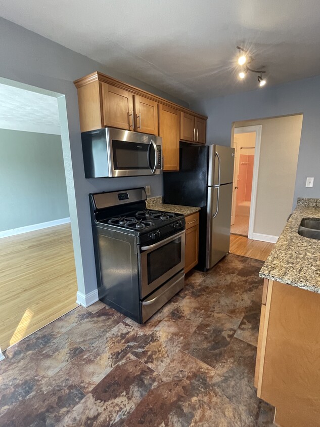
Dishwasher
High Speed Internet Access
Hardwood Floors
Granite Countertops
Often referred to as the “West End,” West Seventh is a convenient neighborhood located on the Riverview Corridor transit system, making travel to Downtown Saint Paul, the Minneapolis-Saint Paul Airport, and the Mall of America simple for locals.
Residents of West Seventh enjoy direct access to Interstate 35E and Xcel Energy Center. There are a plethora of amenities and attractions along the Mississippi River – from parks to historic landmarks and the High Bridge Dog Park.
Many of West Seventh’s restaurants are found along 7th Street West, like Bad Weather Brewing Company, Cossetta’s, and JR Mac’s Bar & Grill. Residents adore the proximity to the airport, and Saint Paul attractions and shopping.
Learn more about living in West Seventh| Colleges & Universities | Distance | ||
|---|---|---|---|
| Colleges & Universities | Distance | ||
| Drive: | 6 min | 2.9 mi | |
| Drive: | 6 min | 3.0 mi | |
| Drive: | 8 min | 3.0 mi | |
| Drive: | 8 min | 4.0 mi |


Transportation options available in Saint Paul include Dale St Station, located 3.5 miles from 1621 7th St W. 1621 7th St W is near Minneapolis-St Paul International/Wold-Chamberlain, located 5.4 miles or 11 minutes away.
| Transit / Subway | Distance | ||
|---|---|---|---|
| Transit / Subway | Distance | ||
| Drive: | 9 min | 3.5 mi | |
| Drive: | 8 min | 3.6 mi | |
| Drive: | 8 min | 3.8 mi | |
| Drive: | 8 min | 3.8 mi | |
| Drive: | 7 min | 3.8 mi |
| Commuter Rail | Distance | ||
|---|---|---|---|
| Commuter Rail | Distance | ||
|
|
Drive: | 7 min | 4.1 mi |
|
|
Drive: | 20 min | 10.0 mi |
|
|
Drive: | 28 min | 20.7 mi |
|
|
Drive: | 38 min | 27.4 mi |
|
|
Drive: | 40 min | 29.0 mi |
| Airports | Distance | ||
|---|---|---|---|
| Airports | Distance | ||
|
Minneapolis-St Paul International/Wold-Chamberlain
|
Drive: | 11 min | 5.4 mi |
Time and distance from 1621 7th St W.
| Shopping Centers | Distance | ||
|---|---|---|---|
| Shopping Centers | Distance | ||
| Drive: | 5 min | 2.0 mi | |
| Drive: | 4 min | 2.0 mi | |
| Drive: | 5 min | 2.0 mi |
| Parks and Recreation | Distance | ||
|---|---|---|---|
| Parks and Recreation | Distance | ||
|
Highland Park and Golf Course
|
Walk: | 11 min | 0.6 mi |
|
Crosby Farm Regional Park
|
Drive: | 5 min | 2.7 mi |
|
Macalester College Observatory
|
Drive: | 6 min | 3.0 mi |
|
Cherokee Regional Park
|
Drive: | 8 min | 3.6 mi |
|
Hidden Falls Park
|
Drive: | 10 min | 3.7 mi |
| Hospitals | Distance | ||
|---|---|---|---|
| Hospitals | Distance | ||
| Drive: | 6 min | 3.2 mi | |
| Drive: | 7 min | 3.8 mi | |
| Drive: | 8 min | 4.6 mi |
| Military Bases | Distance | ||
|---|---|---|---|
| Military Bases | Distance | ||
| Drive: | 9 min | 4.1 mi |
What Are Walk Score®, Transit Score®, and Bike Score® Ratings?
Walk Score® measures the walkability of any address. Transit Score® measures access to public transit. Bike Score® measures the bikeability of any address.
What is a Sound Score Rating?
A Sound Score Rating aggregates noise caused by vehicle traffic, airplane traffic and local sources
1621 7th St W
Saint Paul, MN 55102


