
$2,245 / Month
1936 Carroll Ave Unit 2
Saint Paul, MN 55104
2 Weeks Ago
Favorites
1936 Carroll Ave Unit 2

Favorites
Check Back Soon for Upcoming Availability
| Beds | Baths | Average SF |
|---|---|---|
| 4 Bedrooms 4 Bedrooms 4 Br | 1 Bath 1 Bath 1 Ba | 1,400 SF |
Fees and Policies
The fees below are based on community-supplied data and may exclude additional fees and utilities.
- Dogs Allowed
-
Fees not specified
- Cats Allowed
-
Fees not specified
- Parking
-
Surface Lot--
Details
Utilities Included
-
Gas
-
Water
-
Heat
-
Trash Removal
-
Sewer
-
Air Conditioning
Property Information
-
2 units
About This Property
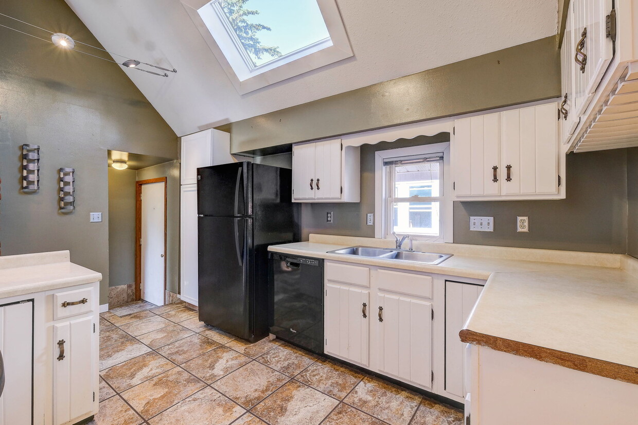
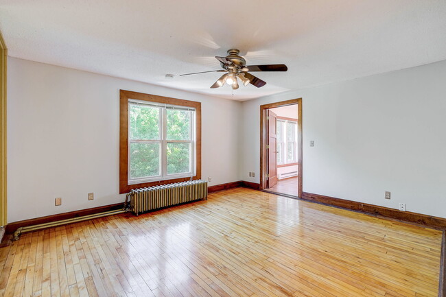
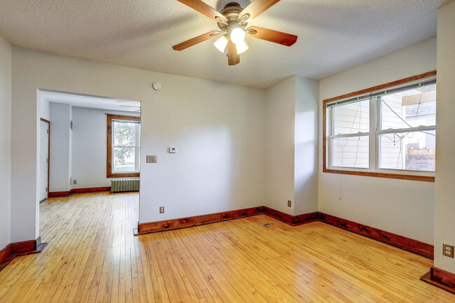
Nice four-bedroom for rent starting in July with heat and most utilities included in rent! This house is centrally located, walking distance to St. Thomas University, restaurants, stores and public transportation including the light rail nearby. Nice four-bedroom one-bath upstairs duplex with FREE private laundry located in unit, five skylights throughout, ceiling fans in every bedroom, nice bedrooms, dishwasher, updated bathroom, and air conditioning in the summer, private backyard, private deck, off-street parking, heat, trash/recycling, non-permit street parking, blocks from bus stop & light rail and St. Thomas University. All maintenance included in rent.
1936 Carroll Ave is an apartment community located in Ramsey County and the 55104 ZIP Code.
Apartment Features
Washer/Dryer
Air Conditioning
Dishwasher
Hardwood Floors
- Washer/Dryer
- Air Conditioning
- Heating
- Ceiling Fans
- Smoke Free
- Cable Ready
- Dishwasher
- Disposal
- Kitchen
- Oven
- Range
- Refrigerator
- Hardwood Floors
- Vaulted Ceiling
- Skylights
- Recycling
- Balcony
- Deck
- Yard
- Lawn
Location
Get Directions
Along the shore of the Mississippi River, Merriam Park West offers riverfront parks, a large golf course, and quaint local restaurants just minutes from downtown Saint Paul, Minnesota. Stop on in at Izzy’s Ice Cream Café, or grab a treat at Black Coffee and Waffle Bar. Local businesses thrive alongside riverfront community spaces like Shadow Falls Park, a picturesque nature preserve.
The University of Saint Thomas resides on the south end of town, and the neighborhood offers a blend of private and public schools, churches, and every day conveniences. Situated just five miles southeast of Minneapolis and seven miles northeast of the Minneapolis-Saint Paul International Airport, this neighborhood is in a premier location for commuting, shopping, dining, and entertainment.
Learn more about living in Merriam Park WestBelow are rent ranges for similar nearby apartments
| Beds | Average Size | Lowest | Typical | Premium |
|---|---|---|---|---|
| Studio Studio Studio | 428 Sq Ft | $640 | $935 | $1,095 |
| 1 Bed 1 Bed 1 Bed | 651-656 Sq Ft | $789 | $1,227 | $1,650 |
| 2 Beds 2 Beds 2 Beds | 894-898 Sq Ft | $1,100 | $1,539 | $2,000 |
| 3 Beds 3 Beds 3 Beds | 1399 Sq Ft | $695 | $2,145 | $3,300 |
| 4 Beds 4 Beds 4 Beds | 1552-1571 Sq Ft | $845 | $2,036 | $6,000 |
Amenities
- Washer/Dryer
- Air Conditioning
- Heating
- Ceiling Fans
- Smoke Free
- Cable Ready
- Dishwasher
- Disposal
- Kitchen
- Oven
- Range
- Refrigerator
- Hardwood Floors
- Vaulted Ceiling
- Skylights
- Recycling
- Balcony
- Deck
- Yard
- Lawn
Expenses
Utilities Included
Gas, Water, Heat, Trash Removal, Sewer, Air Conditioning
Included
Education
| Colleges & Universities | Distance | ||
|---|---|---|---|
| Colleges & Universities | Distance | ||
| Walk: | 20 min | 1.0 mi | |
| Drive: | 3 min | 1.5 mi | |
| Drive: | 3 min | 1.7 mi | |
| Drive: | 6 min | 2.4 mi |
1936 Carroll Ave Unit 2 is within 20 minutes or 1.0 miles from Univ. of St Thomas, St. Paul. It is also near Concordia Univ.-Saint Paul and Macalester College.
Transportation options available in Saint Paul include Fairview Ave Station, located 0.6 mile from 1936 Carroll Ave Unit 2. 1936 Carroll Ave Unit 2 is near Minneapolis-St Paul International/Wold-Chamberlain, located 7.5 miles or 16 minutes away.
| Transit / Subway | Distance | ||
|---|---|---|---|
| Transit / Subway | Distance | ||
| Walk: | 11 min | 0.6 mi | |
| Drive: | 3 min | 1.5 mi | |
| Drive: | 4 min | 1.5 mi | |
| Drive: | 4 min | 1.8 mi | |
| Drive: | 5 min | 1.9 mi |
| Commuter Rail | Distance | ||
|---|---|---|---|
| Commuter Rail | Distance | ||
|
|
Drive: | 10 min | 5.5 mi |
|
|
Drive: | 14 min | 6.2 mi |
|
|
Drive: | 22 min | 14.8 mi |
|
|
Drive: | 32 min | 23.6 mi |
|
|
Drive: | 33 min | 25.3 mi |
| Airports | Distance | ||
|---|---|---|---|
| Airports | Distance | ||
|
Minneapolis-St Paul International/Wold-Chamberlain
|
Drive: | 16 min | 7.5 mi |
Time and distance from 1936 Carroll Ave Unit 2.
| Shopping Centers | Distance | ||
|---|---|---|---|
| Shopping Centers | Distance | ||
| Drive: | 4 min | 1.6 mi | |
| Drive: | 3 min | 1.6 mi | |
| Drive: | 4 min | 1.8 mi |
1936 Carroll Ave Unit 2 has 3 shopping centers within 1.8 miles, which is about a 4-minute drive. The miles and minutes will be for the farthest away property.
| Parks and Recreation | Distance | ||
|---|---|---|---|
| Parks and Recreation | Distance | ||
|
Macalester College Observatory
|
Drive: | 3 min | 1.7 mi |
|
Newell Park
|
Drive: | 4 min | 1.8 mi |
|
Brackett Park
|
Drive: | 5 min | 2.2 mi |
|
Tower Hill Park
|
Drive: | 6 min | 2.3 mi |
|
Longfellow Park
|
Drive: | 6 min | 2.6 mi |
1936 Carroll Ave Unit 2 has 5 parks within 2.6 miles, including Newell Park, Macalester College Observatory, and Brackett Park.
| Hospitals | Distance | ||
|---|---|---|---|
| Hospitals | Distance | ||
| Drive: | 7 min | 3.6 mi | |
| Drive: | 11 min | 4.4 mi | |
| Drive: | 8 min | 4.5 mi |
1936 Carroll Ave Unit 2 has 3 hospitals within 4.5 miles, the nearest is University of Minnesota Medical Center, Fairview which is 3.6 miles away and a 7 minute drive.
| Military Bases | Distance | ||
|---|---|---|---|
| Military Bases | Distance | ||
| Drive: | 14 min | 6.2 mi |
1936 Carroll Ave Unit 2 is 6.2 miles and a 14 minute drive from Fort Snelling Military Reservation.
You May Also Like
Similar Rentals Nearby


What Are Walk Score®, Transit Score®, and Bike Score® Ratings?
Walk Score® measures the walkability of any address. Transit Score® measures access to public transit. Bike Score® measures the bikeability of any address.
What is a Sound Score Rating?
A Sound Score Rating aggregates noise caused by vehicle traffic, airplane traffic and local sources

1936 Carroll Ave
Saint Paul, MN 55104