
Holden House
1554 Midway Pky,
Saint Paul, MN 55108
$1,295 - $2,395
Studio - 2 Beds

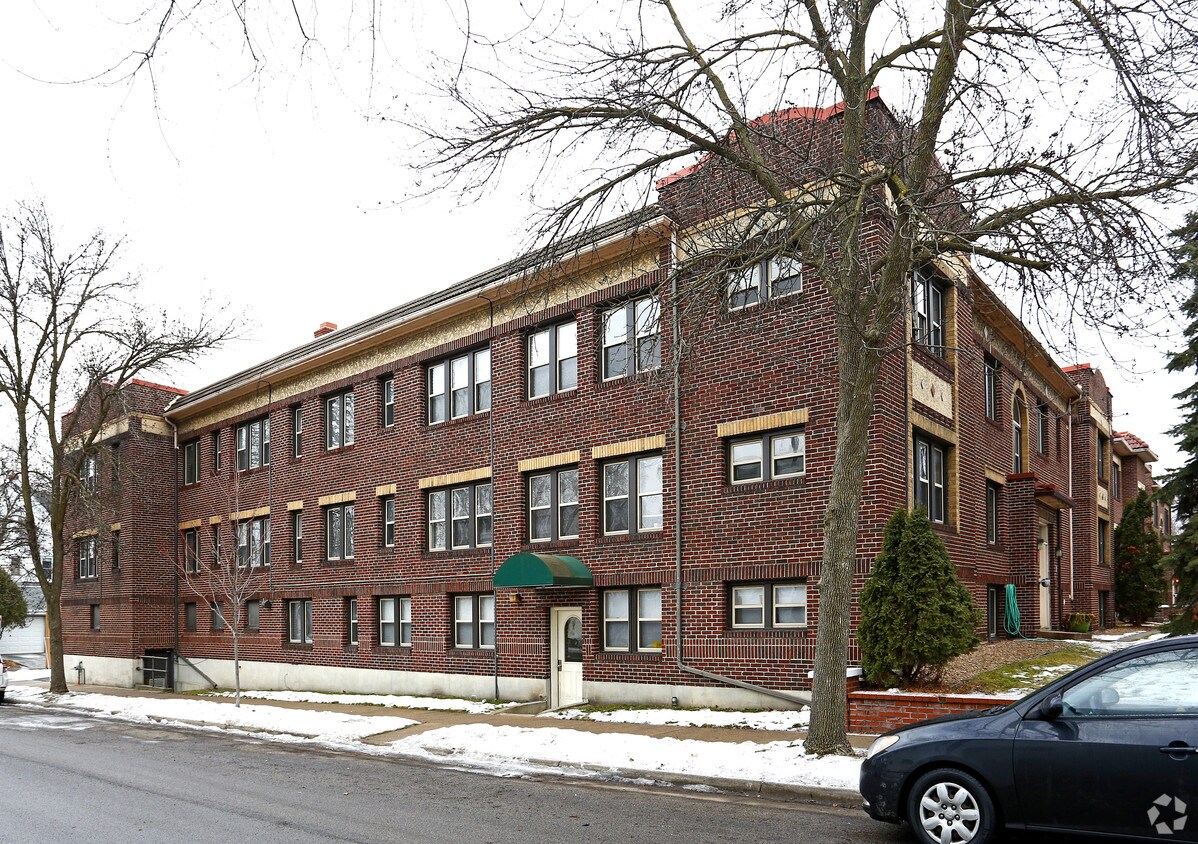
Property Address: 372 N Cleveland Ave Saint Paul, MN 55104 Available: ASAP- 09/01/2021 Offered By: Mint Properties LLC: 612-374-3339 Please call us with any questions or to set up a showing. **HALF MONTH LEASE WITH A 12 MONTH LEASE** Description: Near Merriam Park in Saint Paul, we have a one bedroom available for an ASAP to September 1st move-in. This is studio unit is renting for $875/month. This unit features large closets, original hardwood floors, and vintage built-ins. The building is a beautiful historic brownstone with easy access to both Minneapolis and downtown St. Paul. There are many bus lines in the neighborhood as well as being convenient to the University of St. Thomas. Utilities included in Rent: Heat, Water, Trash Utilities paid by Resident: Electricity, Cooking Gas & Internet/Cable We welcome up to three of your cats without pet rent or pet deposit. Amenities: Washer & Dryer In Basement Storage Unit Parking: $50/month Garage: $80/month Details: Beds/Bath: .0BD/1.0BA Rent: $875 Application Fee: $45.00/applicant Security Deposit: $500 Rental Qualifications: Income (3x the rent amount per month before taxes) Credit (we rent to people without credit) Rental History (we work with first time renters)
372 Cleveland Avenue North is an apartment community located in Ramsey County and the 55104 ZIP Code. This area is served by the St. Paul Public attendance zone.
Washer/Dryer
High Speed Internet Access
Hardwood Floors
Refrigerator
Along the shore of the Mississippi River, Merriam Park West offers riverfront parks, a large golf course, and quaint local restaurants just minutes from downtown Saint Paul, Minnesota. Stop on in at Izzy’s Ice Cream Café, or grab a treat at Black Coffee and Waffle Bar. Local businesses thrive alongside riverfront community spaces like Shadow Falls Park, a picturesque nature preserve.
The University of Saint Thomas resides on the south end of town, and the neighborhood offers a blend of private and public schools, churches, and every day conveniences. Situated just five miles southeast of Minneapolis and seven miles northeast of the Minneapolis-Saint Paul International Airport, this neighborhood is in a premier location for commuting, shopping, dining, and entertainment.
Learn more about living in Merriam Park West| Colleges & Universities | Distance | ||
|---|---|---|---|
| Colleges & Universities | Distance | ||
| Walk: | 18 min | 0.9 mi | |
| Drive: | 4 min | 1.8 mi | |
| Drive: | 4 min | 2.0 mi | |
| Drive: | 6 min | 2.8 mi |


Transportation options available in Saint Paul include Raymond Ave Station, located 1.2 miles from 372 Cleveland Avenue North. 372 Cleveland Avenue North is near Minneapolis-St Paul International/Wold-Chamberlain, located 7.1 miles or 16 minutes away.
| Transit / Subway | Distance | ||
|---|---|---|---|
| Transit / Subway | Distance | ||
| Drive: | 3 min | 1.2 mi | |
| Drive: | 3 min | 1.4 mi | |
| Drive: | 4 min | 1.7 mi | |
| Drive: | 4 min | 1.8 mi | |
| Drive: | 4 min | 2.0 mi |
| Commuter Rail | Distance | ||
|---|---|---|---|
| Commuter Rail | Distance | ||
|
|
Drive: | 13 min | 5.8 mi |
|
|
Drive: | 10 min | 5.9 mi |
|
|
Drive: | 21 min | 14.3 mi |
|
|
Drive: | 31 min | 23.1 mi |
|
|
Drive: | 32 min | 24.8 mi |
| Airports | Distance | ||
|---|---|---|---|
| Airports | Distance | ||
|
Minneapolis-St Paul International/Wold-Chamberlain
|
Drive: | 16 min | 7.1 mi |
Time and distance from 372 Cleveland Avenue North.
| Shopping Centers | Distance | ||
|---|---|---|---|
| Shopping Centers | Distance | ||
| Drive: | 4 min | 2.0 mi | |
| Drive: | 4 min | 2.0 mi | |
| Drive: | 5 min | 2.1 mi |
| Parks and Recreation | Distance | ||
|---|---|---|---|
| Parks and Recreation | Distance | ||
|
Newell Park
|
Drive: | 3 min | 1.6 mi |
|
Tower Hill Park
|
Drive: | 5 min | 2.0 mi |
|
Macalester College Observatory
|
Drive: | 4 min | 2.0 mi |
|
Brackett Park
|
Drive: | 5 min | 2.1 mi |
|
Longfellow Park
|
Drive: | 6 min | 2.4 mi |
| Hospitals | Distance | ||
|---|---|---|---|
| Hospitals | Distance | ||
| Drive: | 6 min | 3.1 mi | |
| Drive: | 11 min | 4.3 mi | |
| Drive: | 10 min | 5.2 mi |
| Military Bases | Distance | ||
|---|---|---|---|
| Military Bases | Distance | ||
| Drive: | 15 min | 5.8 mi |
What Are Walk Score®, Transit Score®, and Bike Score® Ratings?
Walk Score® measures the walkability of any address. Transit Score® measures access to public transit. Bike Score® measures the bikeability of any address.
What is a Sound Score Rating?
A Sound Score Rating aggregates noise caused by vehicle traffic, airplane traffic and local sources
372 Cleveland Ave N
Saint Paul, MN 55104


