
$2,150 / Month
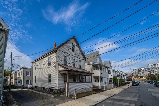
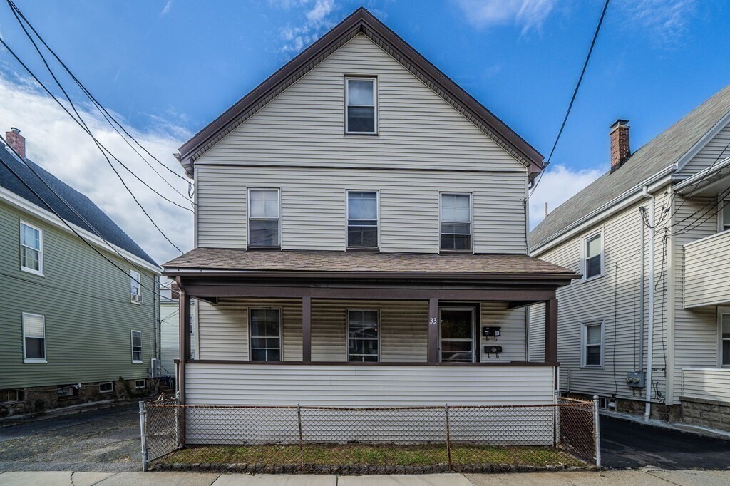
33 Snow St Unit 1
Boston, MA 02135
Today
Favorites
781-752-9181
-
Bedrooms
1
-
Bathrooms
1
-
Square Feet
900 sq ft
-
Available
Available Sep 1
Highlights
- Property is near public transit
- Wood Flooring
- Main Floor Primary Bedroom
- No Cooling
- Park
- Shops
33 Snow St Unit 1

Favorites
About This Home
Available Sep 1
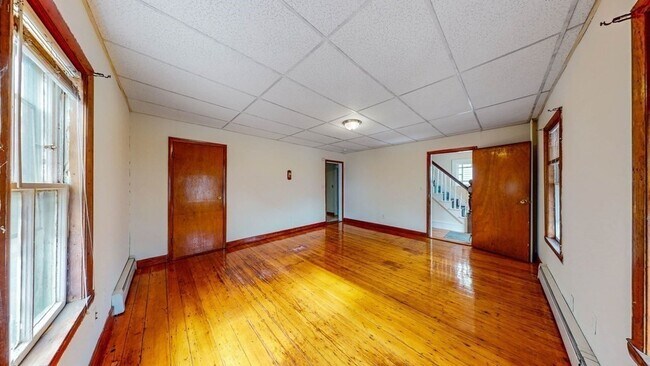
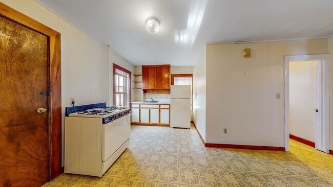
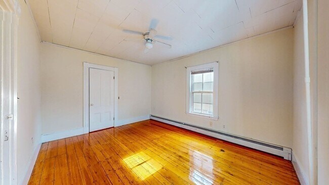
JUST LISTED! Ideally located near St. Elizabeth's Medical Center and just moments from the heart of Brighton Center,this one bedroom apartment offers unbeatable access to a vibrant mix of dining,shopping,and entertainment options. Commuting is a breeze with the B Line less than half a mile away,and convenient access to the 501,57,60,and 65 bus routes nearby—connecting you easily to downtown and beyond. Bright and spacious apartment featuring a generous family room,well-equipped kitchen,comfortable bedroom,in-unit laundry,and off-street parking. Move-in ready for September 1st,2025. Applicants must have strong credit. MLS# 73392640
33 Snow St is an apartment community located in Suffolk County and the 02135 ZIP Code.
* Price shown is base rent and may not include non-optional fees and utilities.
Price, availability, fees, and any applicable rent special are subject to change without notice.
* Square footage definitions vary. Displayed square footage is approximate.
Home Details
Year Built
Built in 1920
Accessible Home Design
Entry on the 1st floor
Basement
Laundry in Basement
Exterior Basement Entry
Bedrooms and Bathrooms
1 Primary Bedroom on Main
1 Full Bathroom
Home Design
Apartment
Interior Spaces
Wood Flooring
900 Sq Ft Home
Kitchen
Range
Listing and Financial Details
Property Available on 9/1/25
Assessor Parcel Number 1217569
Rent includes water, sewer, trash collection, snow removal, parking
Location
Property is near public transit
Parking
1 Car Parking Space
Utilities
No Cooling
Heating System Uses Natural Gas
Community Details
Amenities
Shops
Overview
No Home Owners Association
Pet Policy
No Pets Allowed
Recreation
Park
Fees and Policies
The fees below are based on community-supplied data and may exclude additional fees and utilities.
Contact
- Listed by Elaine Patterson | Coldwell Banker Realty - Westwood
- Phone Number
-
Source
 MLS Property Information Network
The property listing data and information set forth herein were provided to MLS Property Information Network, Inc. from third party sources, including sellers, lessors and public records, and were compiled by MLS Property Information Network, Inc. The property listing data and information are for the personal, non-commercial use of consumers having a good faith interest in purchasing or leasing listed properties of the type displayed to them and may not be used for any purpose other than to identify prospective properties which such consumers may have a good faith interest in purchasing or leasing. MLS Property Information Network, Inc. and its subscribers disclaim any and all representations and warranties as to the accuracy of the property listing data and information set forth herein. All properties are subject to prior sale, change or withdrawal. Copyright © 2025 MLS Property Information Network, Inc. All rights reserved.
Location
Get Directions
Amenities
- Range
- Refrigerator
Saint Elizabeth’s is a Brighton neighborhood situated about 10 miles away from Boston. Thanks to Saint Elizabeth’s top border sitting on Highway 20, commuting in and out of Brighton is easy. Some residents travel by car, but buses and railways make commuting via public transportation a breeze.
The neighborhood’s best amenities are two world-renowned hospitals, Saint Elizabeth’s Medical Center and Franciscan Children’s, that sit on the edge of town. Other great amenities of Saint Elizabeth’s include many local parks like Ringer Playground and Chestnut Hill Reservoir, which has great trails and greenspace. This neighborhood is also equipped with cozy coffee shops, restaurants serving international and American classics, and shopping plazas with grocers and convenience stores.
Saint Elizabeth’s has several rental options ranging from apartments to single-family homes.
Learn more about living in St Elizabeth's
Education
| Colleges & Universities | Distance | ||
|---|---|---|---|
| Colleges & Universities | Distance | ||
| Walk: | 18 min | 1.0 mi | |
| Drive: | 4 min | 1.5 mi | |
| Drive: | 6 min | 2.6 mi | |
| Drive: | 8 min | 3.1 mi |
33 Snow St Unit 1 is within 18 minutes or 1.0 mile from Boston College, Brighton. It is also near Boston College and Boston University.
Transportation options available in Boston include Sutherland Street Station, located 0.4 mile from 33 Snow St Unit 1. 33 Snow St Unit 1 is near General Edward Lawrence Logan International, located 9.3 miles or 18 minutes away.
| Transit / Subway | Distance | ||
|---|---|---|---|
| Transit / Subway | Distance | ||
|
|
Walk: | 8 min | 0.4 mi |
|
|
Walk: | 9 min | 0.5 mi |
|
|
Walk: | 11 min | 0.6 mi |
|
|
Walk: | 14 min | 0.7 mi |
|
|
Walk: | 15 min | 0.8 mi |
| Commuter Rail | Distance | ||
|---|---|---|---|
| Commuter Rail | Distance | ||
|
|
Drive: | 8 min | 3.4 mi |
|
|
Drive: | 7 min | 3.4 mi |
|
|
Drive: | 9 min | 4.0 mi |
|
|
Drive: | 10 min | 4.2 mi |
| Drive: | 9 min | 4.2 mi |
| Airports | Distance | ||
|---|---|---|---|
| Airports | Distance | ||
|
General Edward Lawrence Logan International
|
Drive: | 18 min | 9.3 mi |
Time and distance from 33 Snow St Unit 1.
| Shopping Centers | Distance | ||
|---|---|---|---|
| Shopping Centers | Distance | ||
| Walk: | 12 min | 0.6 mi | |
| Walk: | 18 min | 1.0 mi | |
| Drive: | 4 min | 1.3 mi |
33 Snow St Unit 1 has 3 shopping centers within 1.3 miles, which is about a 4-minute walk. The miles and minutes will be for the farthest away property.
| Parks and Recreation | Distance | ||
|---|---|---|---|
| Parks and Recreation | Distance | ||
|
Chestnut Hill Reservation
|
Walk: | 18 min | 0.9 mi |
|
John Fitzgerald Kennedy National Historic Site
|
Drive: | 4 min | 2.0 mi |
|
Hammond Pond Reservation
|
Drive: | 6 min | 2.6 mi |
|
Frederick Law Olmsted National Historic Site
|
Drive: | 6 min | 2.7 mi |
|
Coit Observatory
|
Drive: | 7 min | 3.0 mi |
33 Snow St Unit 1 has 5 parks within 3.0 miles, including Chestnut Hill Reservation, John Fitzgerald Kennedy National Historic Site, and Frederick Law Olmsted National Historic Site.
| Hospitals | Distance | ||
|---|---|---|---|
| Hospitals | Distance | ||
| Walk: | 7 min | 0.4 mi | |
| Walk: | 9 min | 0.5 mi | |
| Drive: | 4 min | 2.0 mi |
33 Snow St Unit 1 has 3 hospitals within 2.0 miles, the nearest is St. Elizabeth's Medical Center which is 0.4 mile away and a 7 minute walk.
| Military Bases | Distance | ||
|---|---|---|---|
| Military Bases | Distance | ||
| Drive: | 27 min | 12.5 mi | |
| Drive: | 24 min | 13.3 mi |
33 Snow St Unit 1 is 12.5 miles from Hanscom Air Force Base, and is convenient to other military bases, including US Military Reservation.
You May Also Like
Similar Rentals Nearby


What Are Walk Score®, Transit Score®, and Bike Score® Ratings?
Walk Score® measures the walkability of any address. Transit Score® measures access to public transit. Bike Score® measures the bikeability of any address.
What is a Sound Score Rating?
A Sound Score Rating aggregates noise caused by vehicle traffic, airplane traffic and local sources
33 Snow St
Boston, MA 02135