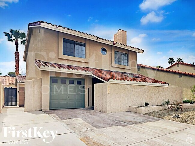
$1,950 / Month
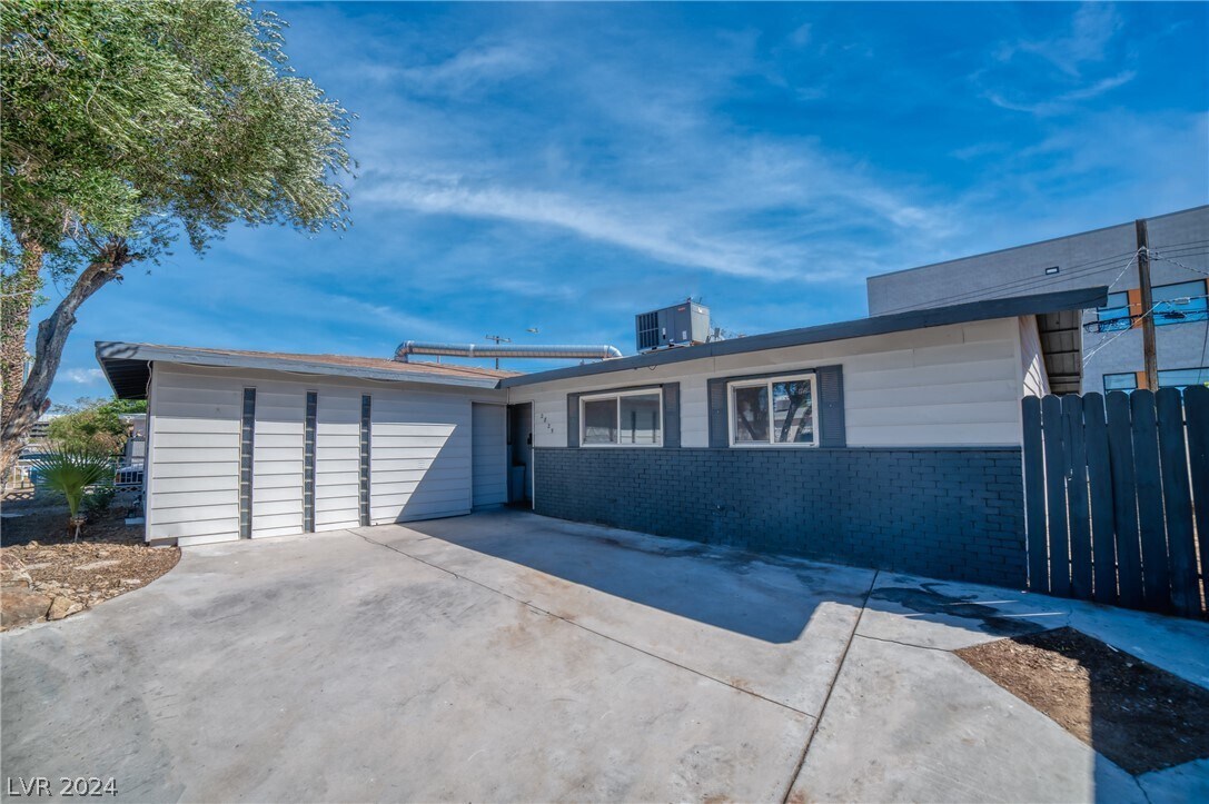
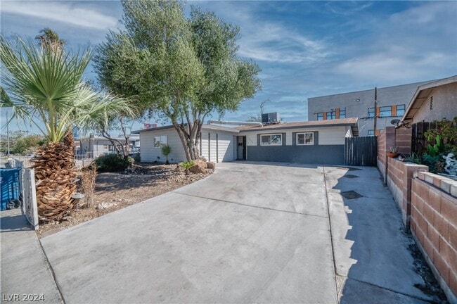
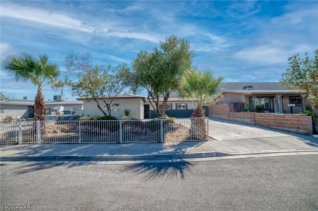
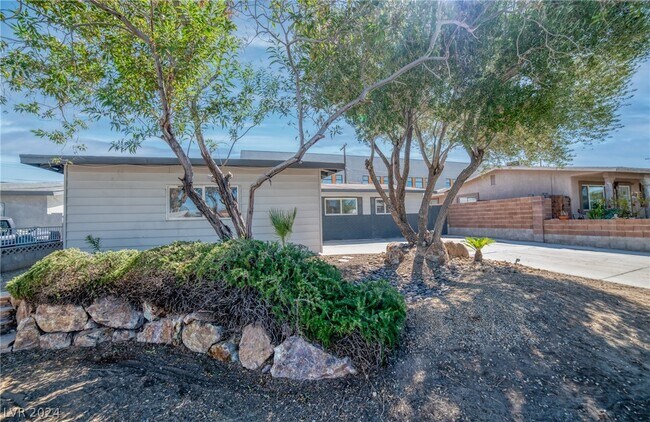
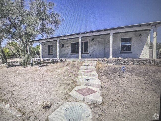
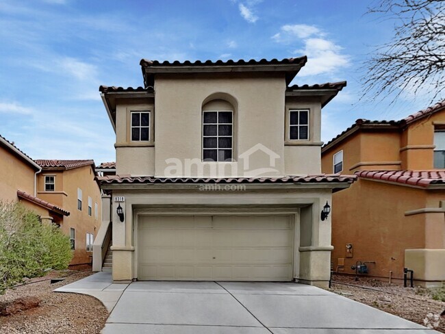
2825 Kings Way
Las Vegas, NV 89102
2 Weeks Ago
Favorites
2825 Kings Way

Favorites
Check Back Soon for Upcoming Availability
| Beds | Baths | Average SF |
|---|---|---|
| 4 Bedrooms 4 Bedrooms 4 Br | 3 Baths 3 Baths 3 Ba | 1,850 SF |
Fees and Policies
The fees below are based on community-supplied data and may exclude additional fees and utilities.
- Dogs Allowed
-
Fees not specified
-
Restrictions:Yes
- Cats Allowed
-
Fees not specified
-
Restrictions:Yes
About This Property
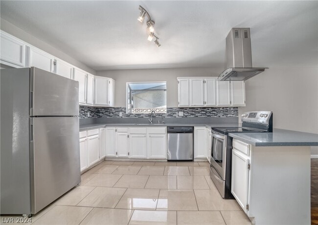
NO HOA, MOVE-IN READY! This property is right in the center of the valley! Features 4 bedrooms / 3 bathrooms. Kitchen with all stainless-steel appliances. Kitchen-living room-dining are all connected with open floorplan that gives this property a homey feel. Low maintenance landscape. ***SOLAR PANELS WITH NO EXTRA CHARGE!!!*** Go check it out!
2825 Kings Way is a house located in Clark County and the 89102 ZIP Code. This area is served by the Clark County attendance zone.
House Features
Washer/Dryer
Air Conditioning
Dishwasher
Microwave
- Washer/Dryer
- Air Conditioning
- Dishwasher
- Disposal
- Microwave
- Oven
- Range
- Refrigerator
- Carpet
- Tile Floors
- Vinyl Flooring
Location
Get Directions
Adjacent to the Las Vegas Strip lies the bustling neighborhood of Richfield. This quaint, family-friendly part of Las Vegas offers great public schools and affordable rentals, ranging from modern apartments to cozy single-family homes. Richfield sits on the western edge of Interstate 15, and across this major route is the Las Vegas Strip, home to infamous restaurants, casinos, bars, and entertainment venues.
Richfield is home to the Palace Station Hotel & Casino, along with various small businesses and restaurants. More dining options are available to the north of Sahara Avenue. Public transportation and easy interstate access make Richfield as convenient as possible. Downtown Las Vegas sits about three miles north east of Richfield, making it the ideal neighborhood for commuters.
Learn more about living in RichfieldBelow are rent ranges for similar nearby apartments
| Beds | Average Size | Lowest | Typical | Premium |
|---|---|---|---|---|
| Studio Studio Studio | 564 Sq Ft | $363 | $1,666 | $3,966 |
| 1 Bed 1 Bed 1 Bed | 670 Sq Ft | $892 | $1,655 | $2,974 |
| 2 Beds 2 Beds 2 Beds | 984-987 Sq Ft | $700 | $1,963 | $3,450 |
| 3 Beds 3 Beds 3 Beds | 1377-1387 Sq Ft | $1,200 | $2,819 | $18,975 |
| 4 Beds 4 Beds 4 Beds | 2138 Sq Ft | $1,687 | $3,344 | $5,900 |
Amenities
- Washer/Dryer
- Air Conditioning
- Dishwasher
- Disposal
- Microwave
- Oven
- Range
- Refrigerator
- Carpet
- Tile Floors
- Vinyl Flooring
Education
| Colleges & Universities | Distance | ||
|---|---|---|---|
| Colleges & Universities | Distance | ||
| Drive: | 5 min | 2.3 mi | |
| Drive: | 9 min | 4.1 mi | |
| Drive: | 12 min | 4.9 mi | |
| Drive: | 13 min | 8.3 mi |
2825 Kings Way is within 5 minutes or 2.3 miles from Nev. State Coll., Shadow Lane. It is also near Southern Nevada, Charleston and UNLV.
Schools


Public Elementary School
Grades PK-5
591 Students
Attendance Zone
Public Middle School
Grades 6-8
1,189 Students
Attendance Zone
Public High School
Grades 9-12
3,094 Students
Attendance Zone
Private Elementary, Middle & High School
Grades 5-12
76 Students
Nearby
Private Elementary & Middle School
Grades PK-8
Nearby
Private Elementary School
Grades K
10 Students
Nearby
School data provided by
 The GreatSchools Rating helps parents compare schools within a state based on a variety of school quality indicators and provides a helpful picture of how effectively each school serves all of its students. Ratings are on a scale of 1 (below average) to 10 (above average) and can include test scores, college readiness, academic progress, advanced courses, equity, discipline and attendance data. We also advise parents to visit schools, consider other information on school performance and programs, and consider family needs as part of the school selection process.
View GreatSchools Rating Methodology
View GreatSchools Rating Methodology
Transportation options available in Las Vegas include Sahara Station, located 2.2 miles from 2825 Kings Way. 2825 Kings Way is near Harry Reid International, located 6.1 miles or 13 minutes away, and Boulder City Municipal, located 26.8 miles or 38 minutes away.
| Transit / Subway | Distance | ||
|---|---|---|---|
| Transit / Subway | Distance | ||
|
Sahara Station
|
Drive: | 4 min | 2.2 mi |
|
Las Vegas Hilton Station
|
Drive: | 7 min | 2.6 mi |
|
Las Vegas Convention Center Station
|
Drive: | 6 min | 2.8 mi |
|
Harrah's/Imperial Palace Station
|
Drive: | 8 min | 3.4 mi |
|
Flamingo/Caesars Palace Station
|
Drive: | 8 min | 4.0 mi |
| Airports | Distance | ||
|---|---|---|---|
| Airports | Distance | ||
|
Harry Reid International
|
Drive: | 13 min | 6.1 mi |
|
Boulder City Municipal
|
Drive: | 38 min | 26.8 mi |
Time and distance from 2825 Kings Way.
| Shopping Centers | Distance | ||
|---|---|---|---|
| Shopping Centers | Distance | ||
| Walk: | 9 min | 0.5 mi | |
| Walk: | 11 min | 0.6 mi | |
| Walk: | 12 min | 0.7 mi |
2825 Kings Way has 3 shopping centers within 0.7 mile, which is about a 12-minute walk. The miles and minutes will be for the farthest away property.
| Parks and Recreation | Distance | ||
|---|---|---|---|
| Parks and Recreation | Distance | ||
|
Springs Preserve
|
Drive: | 7 min | 2.8 mi |
|
Las Vegas Natural History Museum
|
Drive: | 8 min | 4.7 mi |
|
DISCOVERY Children's Museum
|
Drive: | 8 min | 4.8 mi |
|
UNLV Arboretum
|
Drive: | 10 min | 5.2 mi |
|
Shark Reef at Mandalay Bay
|
Drive: | 10 min | 5.8 mi |
2825 Kings Way has 5 parks within 5.8 miles, including Springs Preserve, DISCOVERY Children's Museum, and Las Vegas Natural History Museum.
| Hospitals | Distance | ||
|---|---|---|---|
| Hospitals | Distance | ||
| Drive: | 4 min | 2.2 mi | |
| Drive: | 4 min | 2.2 mi | |
| Drive: | 5 min | 2.6 mi |
2825 Kings Way has 3 hospitals within 2.6 miles, the nearest is Spring Mountain Sahara which is 2.2 miles away and a 4 minute drive.
| Military Bases | Distance | ||
|---|---|---|---|
| Military Bases | Distance | ||
| Drive: | 27 min | 16.1 mi |
2825 Kings Way is 16.1 miles and a 27 minute drive from Nellis Air Force Base.
You May Also Like
Similar Rentals Nearby


What Are Walk Score®, Transit Score®, and Bike Score® Ratings?
Walk Score® measures the walkability of any address. Transit Score® measures access to public transit. Bike Score® measures the bikeability of any address.
What is a Sound Score Rating?
A Sound Score Rating aggregates noise caused by vehicle traffic, airplane traffic and local sources

2825 Kings Way
Las Vegas, NV 89102