1363 County Road B W
1363 County Road B W,
Roseville,
MN
55113
2 Weeks Ago
Favorites
1363 County Road B W
Favorites
Check Back Soon for Upcoming Availability
Fees and Policies
Details
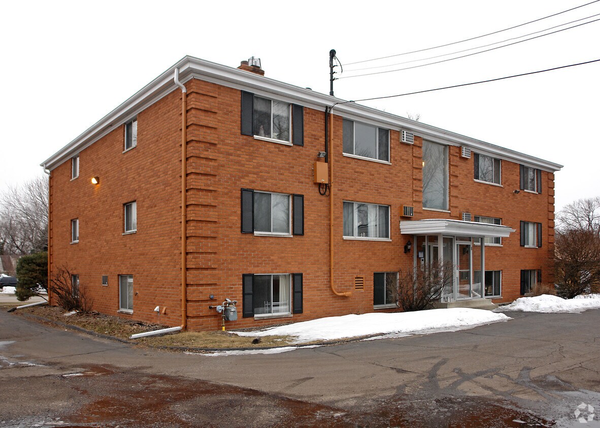
Property Information
-
Built in 1965
-
12 units/2 stories
About 1363 County Road B W Roseville, MN 55113
At 1363 County Road B W, you've discovered your new place. The address for this community is in Roseville at 1363 County Road B W. in the 55113 area. From location to floorplan options, the community staff is ready to help you in finding your new place. Come for a visit to see the available floorplan options. It's all waiting for you at 1363 County Road B W. Contact or drop by the leasing office to schedule a tour.
1363 County Road B W is an apartment community located in Ramsey County and the 55113 ZIP Code. This area is served by the Roseville Public attendance zone.
Location
Get Directions
Nestled in the northern suburbs between Minneapolis and St. Paul, Roseville creates a peaceful environment for renters who want to escape the busy streets of the Twin Cities. More than 30 parks give Roseville its natural charm, but the city's true treasure lies in its thriving retail district. Residents enjoy some of the best shopping outside the Mall of America as well as a vast assortment of restaurants at their fingertips.
Creating the ideal blend of suburban living and modern convenience, Roseville keeps you busy even during the icy winters with several malls, a movie theater and the Roseville Oval, an expansive ice skating rink. Whether you move to Roseville to enjoy a lower cost of living or the vibrant eco-friendly community, you'll find something to love in this charming city.
Learn more about living in Roseville
Education
| Colleges & Universities | Distance | ||
|---|---|---|---|
| Colleges & Universities | Distance | ||
| Drive: | 5 min | 2.5 mi | |
| Drive: | 7 min | 2.6 mi | |
| Drive: | 8 min | 3.7 mi | |
| Drive: | 11 min | 5.9 mi |
1363 County Road B W is within 5 minutes or 2.5 miles from Northwestern College. It is also near Univ. of Minnesota, Saint Paul and Hamline University.
Schools


Public Elementary School
Grades K-6
560 Students
Attendance Zone
Public Elementary, Middle & High School
Grades PK-12
153 Students
Nearby
Public Middle School
Grades 6-8
828 Students
Attendance Zone
Public High School
Grades 9-12
2,327 Students
Attendance Zone
Private Elementary & Middle School
Grades PK-8
101 Students
Nearby
Private Middle & High School
Grades 6-12
Nearby
School data provided by
 The GreatSchools Rating helps parents compare schools within a state based on a variety of school quality indicators and provides a helpful picture of how effectively each school serves all of its students. Ratings are on a scale of 1 (below average) to 10 (above average) and can include test scores, college readiness, academic progress, advanced courses, equity, discipline and attendance data. We also advise parents to visit schools, consider other information on school performance and programs, and consider family needs as part of the school selection process.
View GreatSchools Rating Methodology
Data provided by GreatSchools.org © 2025. All rights reserved.
View GreatSchools Rating Methodology
Data provided by GreatSchools.org © 2025. All rights reserved.
Transportation options available in Roseville include Snelling Ave Station, located 4.0 miles from 1363 County Road B W. 1363 County Road B W is near Minneapolis-St Paul International/Wold-Chamberlain, located 11.6 miles or 24 minutes away.
| Transit / Subway | Distance | ||
|---|---|---|---|
| Transit / Subway | Distance | ||
| Drive: | 8 min | 4.0 mi | |
| Drive: | 9 min | 4.5 mi | |
| Drive: | 10 min | 5.0 mi | |
| Drive: | 10 min | 6.1 mi | |
| Drive: | 11 min | 6.3 mi |
| Commuter Rail | Distance | ||
|---|---|---|---|
| Commuter Rail | Distance | ||
|
|
Drive: | 12 min | 8.2 mi |
|
|
Drive: | 15 min | 8.5 mi |
|
|
Drive: | 16 min | 11.4 mi |
|
|
Drive: | 26 min | 19.9 mi |
|
|
Drive: | 27 min | 21.5 mi |
| Airports | Distance | ||
|---|---|---|---|
| Airports | Distance | ||
|
Minneapolis-St Paul International/Wold-Chamberlain
|
Drive: | 24 min | 11.6 mi |
Time and distance from 1363 County Road B W.
| Shopping Centers | Distance | ||
|---|---|---|---|
| Shopping Centers | Distance | ||
| Walk: | 11 min | 0.6 mi | |
| Walk: | 12 min | 0.7 mi | |
| Drive: | 3 min | 1.2 mi |
1363 County Road B W has 3 shopping centers within 1.2 miles, which is about a 3-minute walk. The miles and minutes will be for the farthest away property.
| Parks and Recreation | Distance | ||
|---|---|---|---|
| Parks and Recreation | Distance | ||
|
Como Park
|
Drive: | 5 min | 1.9 mi |
|
Marjorie McNeely Conservatory
|
Drive: | 6 min | 2.2 mi |
|
Como Park Ski Center
|
Drive: | 5 min | 2.3 mi |
|
Harriet Alexander Nature Center
|
Drive: | 4 min | 2.6 mi |
|
Como Park Zoo
|
Drive: | 7 min | 3.0 mi |
1363 County Road B W has 5 parks within 3.0 miles, including Como Park, Marjorie McNeely Conservatory, and Como Park Zoo.
| Hospitals | Distance | ||
|---|---|---|---|
| Hospitals | Distance | ||
| Drive: | 11 min | 7.7 mi | |
| Drive: | 11 min | 7.7 mi | |
| Drive: | 13 min | 8.2 mi |
1363 County Road B W has 3 hospitals within 8.2 miles, the nearest is Gillette Children's Specialty Hospital which is 7.7 miles away and a 11 minute drive.
| Military Bases | Distance | ||
|---|---|---|---|
| Military Bases | Distance | ||
| Drive: | 23 min | 10.3 mi |
1363 County Road B W is 10.3 miles and a 23 minute drive from Fort Snelling Military Reservation.
You May Also Like
Similar Rentals Nearby


What Are Walk Score®, Transit Score®, and Bike Score® Ratings?
Walk Score® measures the walkability of any address. Transit Score® measures access to public transit. Bike Score® measures the bikeability of any address.
What is a Sound Score Rating?
A Sound Score Rating aggregates noise caused by vehicle traffic, airplane traffic and local sources
Responded To This Review