
Pioneer Endicott
141 4th St E,
Saint Paul, MN 55101
$1,137 - $2,425 Total Monthly Price
Studio - 2 Beds
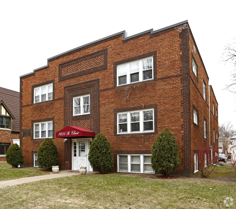

This property is located in the Mac-Groveland neighborhood of St. Paul near Macalester College. The building features on-site laundry, storage units, and secured entry. Beautiful apartments with charm and character.
1915-1923 Saint Clair Ave is an apartment community located in Ramsey County and the 55105 ZIP Code. This area is served by the St. Paul Public School District attendance zone.
High Speed Internet Access
Hardwood Floors
Yard
Ceiling Fans
Macalester-Groveland, sometimes shortened to Mac-Grove, stretches from the eastern banks of the Mississippi River to Summit Hill. Mac-Grove is a largely residential neighborhood, touting an array of apartments and single-family homes available for rent.
The neighborhood contains the picturesque Summit Avenue Historic District, which boasts an impressive collection of Victorian-era homes between dense canopies of lush trees. One block south of Summit Avenue is the vibrant Grand Avenue, which is teeming with specialty shops, independent coffeehouses, and eclectic eateries.
Mac-Grove is famously convenient to multiple private colleges, including the University of Saint Thomas, Saint Catherine University, and Macalester College, making the neighborhood a top choice for many students, faculty, and staff. The community celebrates the start of the summer season every year with the annual Grand Old Day Festival.
Learn more about living in Macalester-GrovelandCompare neighborhood and city base rent averages by bedroom.
| Macalester-Groveland | Saint Paul, MN | |
|---|---|---|
| Studio | $1,186 | $1,145 |
| 1 Bedroom | $1,202 | $1,293 |
| 2 Bedrooms | $1,534 | $1,650 |
| 3 Bedrooms | $2,160 | $2,180 |
| Colleges & Universities | Distance | ||
|---|---|---|---|
| Colleges & Universities | Distance | ||
| Walk: | 17 min | 0.9 mi | |
| Drive: | 2 min | 1.1 mi | |
| Drive: | 3 min | 1.1 mi | |
| Drive: | 5 min | 2.3 mi |


Transportation options available in Saint Paul include Fairview Ave Station, located 1.9 miles from 1915-1923 Saint Clair Ave. 1915-1923 Saint Clair Ave is near Minneapolis-St Paul International/Wold-Chamberlain, located 6.4 miles or 14 minutes away.
| Transit / Subway | Distance | ||
|---|---|---|---|
| Transit / Subway | Distance | ||
| Drive: | 4 min | 1.9 mi | |
| Drive: | 5 min | 2.4 mi | |
| Drive: | 6 min | 2.8 mi | |
| Drive: | 7 min | 3.1 mi | |
|
|
Drive: | 8 min | 3.7 mi |
| Commuter Rail | Distance | ||
|---|---|---|---|
| Commuter Rail | Distance | ||
|
|
Drive: | 12 min | 6.4 mi |
|
|
Drive: | 16 min | 7.3 mi |
|
|
Drive: | 25 min | 15.9 mi |
|
|
Drive: | 34 min | 24.7 mi |
|
|
Drive: | 36 min | 26.4 mi |
| Airports | Distance | ||
|---|---|---|---|
| Airports | Distance | ||
|
Minneapolis-St Paul International/Wold-Chamberlain
|
Drive: | 14 min | 6.4 mi |
Scores provided by
Traffic
-Airport
-Businesses
-Scores provided by
HowLoud What is a Sound Score Rating? A Sound Score Rating aggregates noise caused by vehicle traffic, airplane traffic and local sources. How It WorksTime and distance from 1915-1923 Saint Clair Ave.
| Shopping Centers | Distance | ||
|---|---|---|---|
| Shopping Centers | Distance | ||
| Drive: | 3 min | 1.2 mi | |
| Drive: | 5 min | 1.6 mi |
| Parks and Recreation | Distance | ||
|---|---|---|---|
| Parks and Recreation | Distance | ||
|
Macalester College Observatory
|
Drive: | 3 min | 1.1 mi |
|
Minnehaha Park
|
Drive: | 7 min | 3.0 mi |
|
Minnehaha Falls Pergola Garden
|
Drive: | 8 min | 3.1 mi |
|
Hiawatha School Park
|
Drive: | 8 min | 3.2 mi |
|
Longfellow Park
|
Drive: | 9 min | 3.4 mi |
| Hospitals | Distance | ||
|---|---|---|---|
| Hospitals | Distance | ||
| Drive: | 8 min | 4.2 mi | |
| Drive: | 9 min | 4.7 mi | |
| Drive: | 10 min | 5.3 mi |
| Military Bases | Distance | ||
|---|---|---|---|
| Military Bases | Distance | ||
| Drive: | 12 min | 5.1 mi |
Pets Allowed Fitness Center Pool Dishwasher Refrigerator Clubhouse Maintenance on site
High-Speed Internet Laundry Facilities
Pets Allowed Fitness Center Pool In Unit Washer & Dryer Stainless Steel Appliances Hardwood Floors
Pets Allowed Pool Dishwasher Microwave Granite Countertops
What Are Walk Score®, Transit Score®, and Bike Score® Ratings?
Walk Score® measures the walkability of any address. Transit Score® measures access to public transit. Bike Score® measures the bikeability of any address.
What is a Sound Score Rating?
A Sound Score Rating aggregates noise caused by vehicle traffic, airplane traffic and local sources.

1915-1923 Saint Clair Ave
Saint Paul, MN 55105


