

$4,600 / Month
114 Hemenway St Unit 305
Boston, MA 02115
2 Weeks Ago
Favorites
114 Hemenway St Unit 305

Favorites
Check Back Soon for Upcoming Availability
| Beds | Baths | Average SF |
|---|---|---|
| 2 Bedrooms 2 Bedrooms 2 Br | 1 Bath 1 Bath 1 Ba | 800 SF |
Fees and Policies
The fees below are based on community-supplied data and may exclude additional fees and utilities.
- Cats Allowed
-
Fees not specified
-
Weight limit--
-
Pet Limit--
- Parking
-
Street--
Details
Utilities Included
-
Water
-
Heat
-
Trash Removal
-
Sewer
Property Information
-
3 units
About This Property
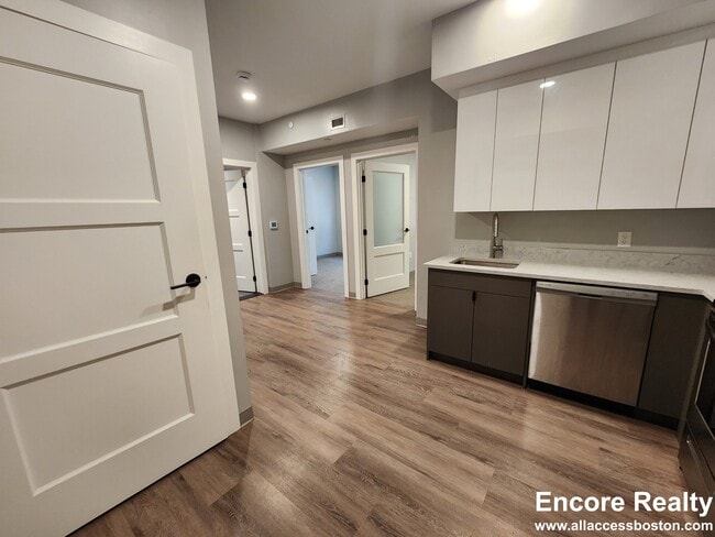
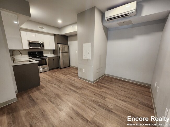
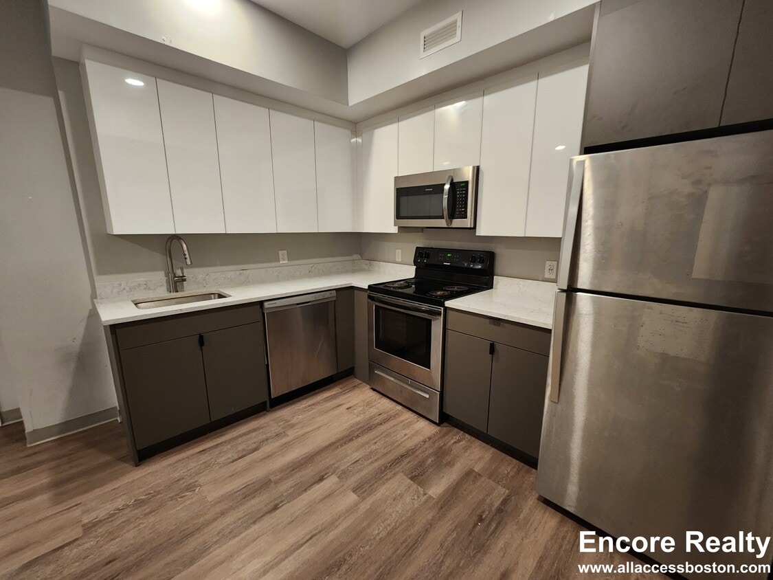
NO BROKER FEE!! Beautiful 2-bedroom apartment in a fantastic location! Excellent management company. Perfect layout for flexible living options. Must see! Call today for more details and a showing. newly renovated Hardwood Floors open-concept quartz countertops marble shower Washer/Dryer in unit!
114 Hemenway St is an apartment community located in Suffolk County and the 02115 ZIP Code. This area is served by the Boston Public Schools attendance zone.
Apartment Features
Washer/Dryer
Air Conditioning
Dishwasher
Hardwood Floors
- Washer/Dryer
- Air Conditioning
- Dishwasher
- Quartz Countertops
- Hardwood Floors
- Wheelchair Accessible
- Elevator
Location
Get Directions
Tree-filled, historic, and packed with educational opportunity, there's no other neighborhood quite like Fenway. The neighborhood may be most well-known for its titular attraction, Fenway Park, home of the Boston Red Sox. However, the area is also renowned for its sprawling greenspace. The name "Fenway" refers to the neighborhood’s lush parkway and tree-filled paths that wind lazily through the area, forming part of Frederick Law Olmsted’s “Emerald Necklace Plan” (a chain of parks throughout Boston). The Fenway opened in 1876, and its route includes the Museum of Fine Arts and the Isabella Steward Gardner Museum.
Learn more about living in FenwayBelow are rent ranges for similar nearby apartments
| Beds | Average Size | Lowest | Typical | Premium |
|---|---|---|---|---|
| Studio Studio Studio | 2656 Sq Ft | $1,700 | $2,512 | $6,645 |
| 1 Bed 1 Bed 1 Bed | 2729-2732 Sq Ft | $1,700 | $3,209 | $8,950 |
| 2 Beds 2 Beds 2 Beds | 2812-2814 Sq Ft | $1,950 | $4,124 | $16,000 |
| 3 Beds 3 Beds 3 Beds | 3007-3008 Sq Ft | $1,680 | $5,156 | $30,000 |
| 4 Beds 4 Beds 4 Beds | 4905-4907 Sq Ft | $1,400 | $7,603 | $100,000 |
Amenities
- Washer/Dryer
- Air Conditioning
- Dishwasher
- Quartz Countertops
- Hardwood Floors
- Wheelchair Accessible
- Elevator
Expenses
Utilities Included
Water, Heat, Trash Removal, Sewer
Included
Education
| Colleges & Universities | Distance | ||
|---|---|---|---|
| Colleges & Universities | Distance | ||
| Walk: | 6 min | 0.4 mi | |
| Walk: | 7 min | 0.4 mi | |
| Walk: | 10 min | 0.5 mi | |
| Walk: | 15 min | 0.8 mi |
114 Hemenway St Unit 305 is within 6 minutes or 0.4 mile from Northeastern University. It is also near Berklee College of Music and Wentworth Inst. of Technology.
Schools


Public Elementary & Middle School
Grades PK-8
352 Students
Attendance Zone
Public Elementary & Middle School
Grades PK-8
426 Students
Attendance Zone
Public Middle & High School
Grades 7-12
26 Students
Attendance Zone
Public Middle & High School
Grades 7-12
2,423 Students
Attendance Zone
Charter High School
Grades 9-12
364 Students
Attendance Zone
Private Elementary School
Grades PK-6
349 Students
Nearby
Private Elementary & Middle School
Grades 5-8
Nearby
Private Middle & High School
Grades 7-12
204 Students
Nearby
School data provided by
 The GreatSchools Rating helps parents compare schools within a state based on a variety of school quality indicators and provides a helpful picture of how effectively each school serves all of its students. Ratings are on a scale of 1 (below average) to 10 (above average) and can include test scores, college readiness, academic progress, advanced courses, equity, discipline and attendance data. We also advise parents to visit schools, consider other information on school performance and programs, and consider family needs as part of the school selection process.
View GreatSchools Rating Methodology
Data provided by GreatSchools.org © 2025. All rights reserved.
View GreatSchools Rating Methodology
Data provided by GreatSchools.org © 2025. All rights reserved.
Transportation options available in Boston include Northeastern University Station, located 0.3 mile from 114 Hemenway St Unit 305. 114 Hemenway St Unit 305 is near General Edward Lawrence Logan International, located 6.0 miles or 13 minutes away.
| Transit / Subway | Distance | ||
|---|---|---|---|
| Transit / Subway | Distance | ||
|
|
Walk: | 5 min | 0.3 mi |
|
|
Walk: | 6 min | 0.3 mi |
|
|
Walk: | 8 min | 0.4 mi |
|
|
Walk: | 8 min | 0.4 mi |
|
|
Walk: | 9 min | 0.5 mi |
| Commuter Rail | Distance | ||
|---|---|---|---|
| Commuter Rail | Distance | ||
|
|
Walk: | 12 min | 0.6 mi |
|
|
Drive: | 6 min | 1.4 mi |
| Drive: | 4 min | 1.9 mi | |
|
|
Drive: | 7 min | 2.2 mi |
|
|
Drive: | 6 min | 3.6 mi |
| Airports | Distance | ||
|---|---|---|---|
| Airports | Distance | ||
|
General Edward Lawrence Logan International
|
Drive: | 13 min | 6.0 mi |
Time and distance from 114 Hemenway St Unit 305.
| Shopping Centers | Distance | ||
|---|---|---|---|
| Shopping Centers | Distance | ||
| Drive: | 3 min | 1.1 mi | |
| Drive: | 8 min | 4.6 mi | |
| Drive: | 8 min | 4.8 mi |
114 Hemenway St Unit 305 has 3 shopping centers within 4.8 miles, which is about a 8-minute drive. The miles and minutes will be for the farthest away property.
| Parks and Recreation | Distance | ||
|---|---|---|---|
| Parks and Recreation | Distance | ||
|
Charles River Reservation
|
Walk: | 20 min | 1.0 mi |
|
Coit Observatory
|
Drive: | 3 min | 1.5 mi |
|
Roxbury Heritage State Park
|
Drive: | 3 min | 1.5 mi |
|
Boston Public Garden
|
Drive: | 5 min | 1.6 mi |
|
Boston African American National Historic Site
|
Drive: | 6 min | 2.1 mi |
114 Hemenway St Unit 305 has 5 parks within 2.1 miles, including Charles River Reservation, Roxbury Heritage State Park, and Coit Observatory.
| Hospitals | Distance | ||
|---|---|---|---|
| Hospitals | Distance | ||
| Walk: | 20 min | 1.0 mi | |
| Drive: | 3 min | 1.3 mi | |
| Drive: | 3 min | 1.3 mi |
114 Hemenway St Unit 305 has 3 hospitals within 1.3 miles, the nearest is Boston Children's Hospital which is 1.0 miles away and a 20 minute walk.
| Military Bases | Distance | ||
|---|---|---|---|
| Military Bases | Distance | ||
| Drive: | 29 min | 15.5 mi | |
| Drive: | 28 min | 15.7 mi |
114 Hemenway St Unit 305 is 15.5 miles from Hanscom Air Force Base, and is convenient to other military bases, including US Military Reservation.
You May Also Like
Similar Rentals Nearby


What Are Walk Score®, Transit Score®, and Bike Score® Ratings?
Walk Score® measures the walkability of any address. Transit Score® measures access to public transit. Bike Score® measures the bikeability of any address.
What is a Sound Score Rating?
A Sound Score Rating aggregates noise caused by vehicle traffic, airplane traffic and local sources
114 Hemenway St
Boston, MA 02115