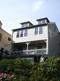
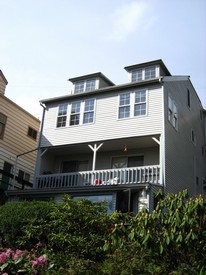
Sand Point Way Apartments
12340 Sand Point Way,
Seattle,
WA
98125
2 Weeks Ago
Favorites
Sand Point Way Apartments
Favorites
Check Back Soon for Upcoming Availability
| Beds | Baths | Average SF | Availability |
|---|---|---|---|
| 1 Bedroom 1 Bedroom 1 Br | 1 Bath 1 Bath 1 Ba | — | Not Available |
Fees and Policies
Details
Property Information
-
Built in 1930
-
6 units/2 stories
About Sand Point Way Apartments
Find your new place at Sand Point Way Apartments. The address for this community is at 12340 Sand Point Way in Seattle. The leasing staff is waiting to show you all that this community has to offer. Make sure you to see the current floorplan options. Contact us or drop by to find out the availability today and make your move to Sand Point Way Apartments.
Sand Point Way Apartments is an apartment community located in King County and the 98125 ZIP Code. This area is served by the Seattle Public Schools attendance zone.
Location
Get Directions
Located about eight miles north of Downtown Seattle, the area of Lake City was once a railroad stop. It was named in 1906 and quickly developed into a suburb of Seattle. During Prohibition, the area was unincorporated. So when Seattle joined Prohibition, Lake City supplied the roadhouses and speakeasies barred from the nearby city. Lake City became a Seattle neighborhood in the mid-1950s. With Lake Washington as the neighborhood’s sparkling gem, residents are rediscovering this northern neighborhood.
Lake City stretches from the lake to roughly 15th Avenue in North Seattle. While the speakeasies are long gone, there are several popular destinations along Lake City Way, including HellBent Brewing Company Elliott Bay Public House & Brewery, Brother Barrel, and 2C Thai. If you are moving to Lake City with a pet, you’ll appreciate Dogwood Play Park, an indoor dog park and bar complete with a treat bar and birthday cakes for pet parties.
Learn more about living in Lake CityBelow are rent ranges for similar nearby apartments
| Beds | Average Size | Lowest | Typical | Premium |
|---|---|---|---|---|
| Studio Studio Studio | 342-364 Sq Ft | $1,100 | $1,329 | $4,095 |
| 1 Bed 1 Bed 1 Bed | 657-677 Sq Ft | $1,025 | $1,835 | $4,208 |
| 2 Beds 2 Beds 2 Beds | 867-903 Sq Ft | $1,399 | $2,591 | $8,515 |
| 3 Beds 3 Beds 3 Beds | 1270 Sq Ft | $2,150 | $3,766 | $9,397 |
| 4 Beds 4 Beds 4 Beds | 2374 Sq Ft | $4,000 | $4,564 | $5,500 |
Education
| Colleges & Universities | Distance | ||
|---|---|---|---|
| Colleges & Universities | Distance | ||
| Drive: | 12 min | 3.8 mi | |
| Drive: | 15 min | 5.2 mi | |
| Drive: | 14 min | 5.5 mi | |
| Drive: | 16 min | 6.8 mi |
Sand Point Way Apartments is within 12 minutes or 3.8 miles from North Seattle College. It is also near Shoreline Community College and University of Washington.
Schools


Public Elementary School
Grades PK-5
499 Students
Nearby
Public Elementary School
Grades K-5
257 Students
Attendance Zone
Public Middle School
Grades 6-8
883 Students
Attendance Zone
Public High School
Grades 9-12
1,105 Students
Attendance Zone
Private Elementary, Middle & High School
Grades PK-12
399 Students
Nearby
Private Elementary & Middle School
Grades PK-8
181 Students
Nearby
Private Elementary School
Grades PK-6
Nearby
School data provided by
 The GreatSchools Rating helps parents compare schools within a state based on a variety of school quality indicators and provides a helpful picture of how effectively each school serves all of its students. Ratings are on a scale of 1 (below average) to 10 (above average) and can include test scores, college readiness, academic progress, advanced courses, equity, discipline and attendance data. We also advise parents to visit schools, consider other information on school performance and programs, and consider family needs as part of the school selection process.
View GreatSchools Rating Methodology
Data provided by GreatSchools.org © 2025. All rights reserved.
View GreatSchools Rating Methodology
Data provided by GreatSchools.org © 2025. All rights reserved.
Transportation options available in Seattle include Northgate Station, located 3.0 miles from Sand Point Way Apartments. Sand Point Way Apartments is near Seattle Paine Field International, located 17.3 miles or 29 minutes away, and Seattle-Tacoma International, located 22.9 miles or 37 minutes away.
| Transit / Subway | Distance | ||
|---|---|---|---|
| Transit / Subway | Distance | ||
| Drive: | 9 min | 3.0 mi | |
| Drive: | 10 min | 3.9 mi | |
| Drive: | 10 min | 5.0 mi | |
| Drive: | 13 min | 5.5 mi | |
| Drive: | 16 min | 7.7 mi |
| Commuter Rail | Distance | ||
|---|---|---|---|
| Commuter Rail | Distance | ||
|
|
Drive: | 18 min | 9.7 mi |
|
|
Drive: | 22 min | 11.1 mi |
|
|
Drive: | 35 min | 20.2 mi |
|
|
Drive: | 33 min | 21.3 mi |
|
|
Drive: | 35 min | 22.4 mi |
| Airports | Distance | ||
|---|---|---|---|
| Airports | Distance | ||
|
Seattle Paine Field International
|
Drive: | 29 min | 17.3 mi |
|
Seattle-Tacoma International
|
Drive: | 37 min | 22.9 mi |
Time and distance from Sand Point Way Apartments.
| Shopping Centers | Distance | ||
|---|---|---|---|
| Shopping Centers | Distance | ||
| Walk: | 13 min | 0.7 mi | |
| Walk: | 13 min | 0.7 mi | |
| Drive: | 7 min | 2.3 mi |
Sand Point Way Apartments has 3 shopping centers within 2.3 miles, which is about a 7-minute walk. The miles and minutes will be for the farthest away property.
| Parks and Recreation | Distance | ||
|---|---|---|---|
| Parks and Recreation | Distance | ||
|
Northacres Park
|
Drive: | 6 min | 2.2 mi |
|
Paramount Park Open Space
|
Drive: | 8 min | 2.9 mi |
|
Paramount School Park
|
Drive: | 8 min | 3.2 mi |
|
Hamlin Park
|
Drive: | 10 min | 3.5 mi |
|
Saint Edward State Park
|
Drive: | 14 min | 6.5 mi |
Sand Point Way Apartments has 5 parks within 6.5 miles, including Northacres Park, Paramount Park Open Space, and Paramount School Park.
| Hospitals | Distance | ||
|---|---|---|---|
| Hospitals | Distance | ||
| Drive: | 9 min | 3.1 mi | |
| Drive: | 13 min | 4.6 mi | |
| Drive: | 15 min | 7.7 mi |
Sand Point Way Apartments has 3 hospitals within 7.7 miles, the nearest is Northwest Hospital & Medical Center which is 3.1 miles away and a 9 minute drive.
| Military Bases | Distance | ||
|---|---|---|---|
| Military Bases | Distance | ||
| Drive: | 29 min | 10.3 mi | |
| Drive: | 80 min | 32.5 mi |
Sand Point Way Apartments is 10.3 miles from Fort Lawton Military Reserve, and is convenient to other military bases, including Keyport Naval Reservation.
You May Also Like
What neighborhood is the property located in?
Sand Point Way Apartments is in Lake City in the city of Seattle. Here you’ll find three shopping centers within 2.3 miles of the property. Five parks are within 6.5 miles, including Northacres Park, Paramount Park Open Space, and Paramount School Park.
Similar Rentals Nearby


What Are Walk Score®, Transit Score®, and Bike Score® Ratings?
Walk Score® measures the walkability of any address. Transit Score® measures access to public transit. Bike Score® measures the bikeability of any address.
What is a Sound Score Rating?
A Sound Score Rating aggregates noise caused by vehicle traffic, airplane traffic and local sources
12340 Sand Point Way
Seattle, WA 98125
Responded To This Review