
Living at NoHo
11059 McCormick St,
North Hollywood, CA 91601
$2,220 - $3,764 Total Monthly Price
Studio - 3 Beds
Find your new home at 540 N Florence St. You'll find this community in the Magnolia Park area of Burbank. Select from 1 to 2 bedroom apartments. The leasing team is ready to help you find the best floor plan for your lifestyle. Drop by the leasing office to see available floor plans and make your move to 540 N Florence St.
540 N Florence St is an apartment community located in Los Angeles County and the 91505 ZIP Code. This area is served by the Burbank Unified School District attendance zone.
Magnolia Park is an eclectic neighborhood in west Burbank home to funky shops, art galleries, and thrift stores that sit side-by-side to create a charming oasis. This close-knit neighborhood and park-like community is just 14 miles northwest of Downtown Los Angeles and only two miles west of Downtown Burbank. Enjoy annual movie nights, seasonal events, and food truck festivals when you become a renter in Magnolia Park. Locals enjoy strolling or biking up to Magnolia Boulevard to grab a bite to eat. Porto’s Bakery and Café is a famous Cuban bakery that attracts people from all over the city. The single-family homes and apartments for rent in this neighborhood range from affordable to upscale, and locals regularly spend their leisure time in the very park that gives the neighborhood its name.
Learn more about living in Magnolia ParkCompare neighborhood and city base rent averages by bedroom.
| Magnolia Park | Burbank, CA | |
|---|---|---|
| Studio | $1,942 | $1,913 |
| 1 Bedroom | $2,313 | $2,236 |
| 2 Bedrooms | $2,731 | $2,949 |
| 3 Bedrooms | $3,452 | $3,979 |
| Colleges & Universities | Distance | ||
|---|---|---|---|
| Colleges & Universities | Distance | ||
| Drive: | 4 min | 1.8 mi | |
| Drive: | 7 min | 3.2 mi | |
| Drive: | 11 min | 5.6 mi | |
| Drive: | 11 min | 6.3 mi |


Transportation options available in Burbank include North Hollywood Station, located 2.8 miles from 540 N Florence St. 540 N Florence St is near Bob Hope, located 4.8 miles or 10 minutes away, and Los Angeles International, located 18.9 miles or 37 minutes away.
| Transit / Subway | Distance | ||
|---|---|---|---|
| Transit / Subway | Distance | ||
|
|
Drive: | 6 min | 2.8 mi |
|
|
Drive: | 7 min | 3.2 mi |
|
|
Drive: | 10 min | 5.5 mi |
|
|
Drive: | 10 min | 6.0 mi |
|
|
Drive: | 12 min | 6.8 mi |
| Commuter Rail | Distance | ||
|---|---|---|---|
| Commuter Rail | Distance | ||
|
|
Drive: | 5 min | 2.0 mi |
|
|
Drive: | 6 min | 2.8 mi |
| Drive: | 6 min | 3.2 mi | |
|
|
Drive: | 9 min | 5.0 mi |
|
|
Drive: | 11 min | 7.1 mi |
| Airports | Distance | ||
|---|---|---|---|
| Airports | Distance | ||
|
Bob Hope
|
Drive: | 10 min | 4.8 mi |
|
Los Angeles International
|
Drive: | 37 min | 18.9 mi |
Scores provided by
Traffic
-Airport
-Businesses
-Scores provided by
HowLoud What is a Sound Score Rating? A Sound Score Rating aggregates noise caused by vehicle traffic, airplane traffic and local sources. How It WorksTime and distance from 540 N Florence St.
| Shopping Centers | Distance | ||
|---|---|---|---|
| Shopping Centers | Distance | ||
| Walk: | 12 min | 0.7 mi | |
| Walk: | 18 min | 1.0 mi | |
| Walk: | 20 min | 1.1 mi |
| Parks and Recreation | Distance | ||
|---|---|---|---|
| Parks and Recreation | Distance | ||
|
Los Angeles Zoo
|
Drive: | 16 min | 5.9 mi |
|
Runyon Canyon
|
Drive: | 12 min | 6.0 mi |
|
Bird Sanctuary
|
Drive: | 14 min | 8.1 mi |
|
Griffith Observatory
|
Drive: | 18 min | 9.3 mi |
|
Griffith Park
|
Drive: | 27 min | 11.6 mi |
| Hospitals | Distance | ||
|---|---|---|---|
| Hospitals | Distance | ||
| Walk: | 18 min | 1.0 mi | |
| Drive: | 11 min | 6.4 mi | |
| Drive: | 10 min | 6.9 mi |
| Military Bases | Distance | ||
|---|---|---|---|
| Military Bases | Distance | ||
| Drive: | 37 min | 20.6 mi | |
| Drive: | 50 min | 36.6 mi | |
| Drive: | 52 min | 39.5 mi |
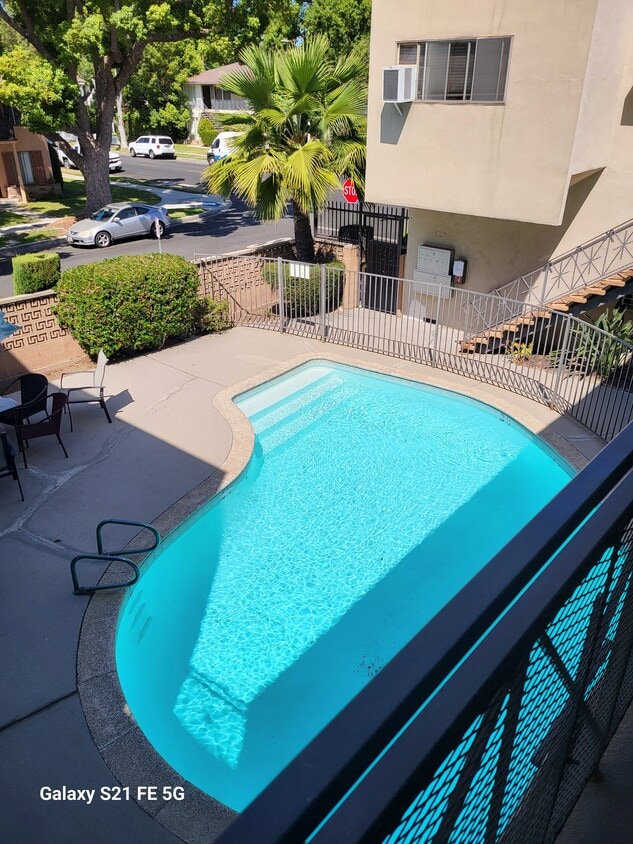
Pets Allowed Fitness Center Pool Maintenance on site High-Speed Internet Controlled Access EV Charging
What Are Walk Score®, Transit Score®, and Bike Score® Ratings?
Walk Score® measures the walkability of any address. Transit Score® measures access to public transit. Bike Score® measures the bikeability of any address.
What is a Sound Score Rating?
A Sound Score Rating aggregates noise caused by vehicle traffic, airplane traffic and local sources.

540 N Florence St
Burbank, CA 91505


