$3,200 / Month
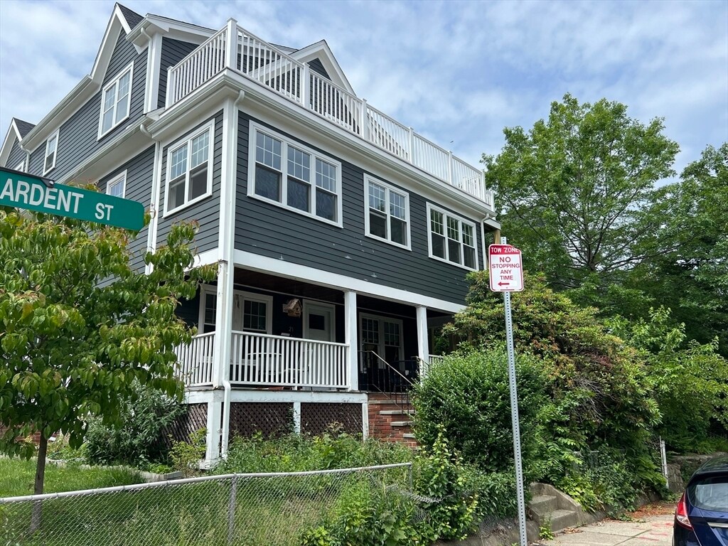
33 Colberg Ave Unit 2
Boston, MA 02131
Today
Favorites
617-794-3532
-
Bedrooms
2
-
Bathrooms
1
-
Square Feet
1,200 sq ft
-
Available
Available Aug 1
33 Colberg Ave Unit 2

Favorites
About This Home
$3,200 deposit,
Available Aug 1
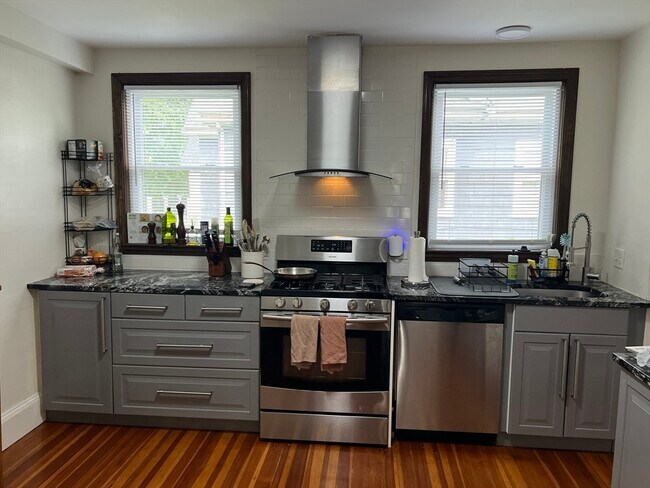
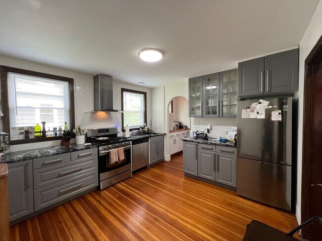
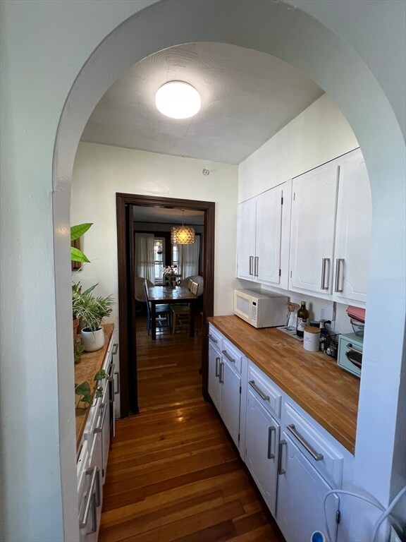
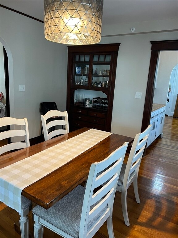
New construction meets old world charm in this 2 bedroom,1 bath second floor sunny corner unit. Large,airy,open living and dining room with enough room to hold a table for six features an antique hutch. The eat-in kitchen has stainless steel appliances,granite countertops,a full-size dishwasher,as well as a butler's pantry,perfect for those who love to cook. A newly added 189 square foot all-season porch with energy efficient windows is perfect for entertaining,a personal home gym or home office. Additional amenities include one off-street parking space. Shared laundry in the basement,and shared yard space. Close proximity to Belgrade commuter rail station,grocery,shopping,and restaurants. On a Saturday,head into Roslindale Village (only a mile away) to enjoy one of Boston's best farmer's markets. Cats allowed--no dogs. More pics to come - currently occupied. MLS# 73391705
33 Colberg Ave is an apartment community located in Suffolk County and the 02131 ZIP Code.
* Price shown is base rent and may not include non-optional fees and utilities.
Price, availability, fees, and any applicable rent special are subject to change without notice.
* Square footage definitions vary. Displayed square footage is approximate.
Features
Dishwasher
Refrigerator
Disposal
Range
- Dishwasher
- Disposal
- Range
- Refrigerator
- Porch
Fees and Policies
The fees below are based on community-supplied data and may exclude additional fees and utilities.
Pet policies are negotiable.
Contact
- Listed by Mary Rush | Gilmore Murphy Realty LLC
- Phone Number
-
Source
 MLS Property Information Network
The property listing data and information set forth herein were provided to MLS Property Information Network, Inc. from third party sources, including sellers, lessors and public records, and were compiled by MLS Property Information Network, Inc. The property listing data and information are for the personal, non-commercial use of consumers having a good faith interest in purchasing or leasing listed properties of the type displayed to them and may not be used for any purpose other than to identify prospective properties which such consumers may have a good faith interest in purchasing or leasing. MLS Property Information Network, Inc. and its subscribers disclaim any and all representations and warranties as to the accuracy of the property listing data and information set forth herein. All properties are subject to prior sale, change or withdrawal. Copyright © 2025 MLS Property Information Network, Inc. All rights reserved.
Location
Get Directions
Amenities
- Dishwasher
- Disposal
- Range
- Refrigerator
- Porch
Metropolitan Hill-Beech Street is a predominantly residential portion of Roslindale, brimming with colorful historic buildings strewn along quiet tree-lined streets. Metropolitan Hill-Beech Street also contains a slew of locally owned shops and diverse eateries on Washington Street in addition to the vibrant Roslindale Village Main Street, which is commonly referred to as Rozzie Square.
Area residents enjoy a small-town feel, and quick access to lush green spaces like Bellevue Hill Park, West Roxbury Parkway, Sherrin Woods, and the George Wright Golf Course. The expansive Franklin Park and its many attractions are just a few minutes north of the area as well. Convenience to the MBTA Needham Line makes commuting and traveling into Boston a breeze.
Learn more about living in Metropolitan Hill-Beech St
Education
| Colleges & Universities | Distance | ||
|---|---|---|---|
| Colleges & Universities | Distance | ||
| Drive: | 12 min | 4.8 mi | |
| Drive: | 11 min | 4.8 mi | |
| Drive: | 13 min | 5.6 mi | |
| Drive: | 12 min | 5.8 mi |
33 Colberg Ave Unit 2 is within 12 minutes or 4.8 miles from Curry College. It is also near Boston College and MCPHS University, Boston.
Transportation options available in Boston include Forest Hills Station, located 2.0 miles from 33 Colberg Ave Unit 2. 33 Colberg Ave Unit 2 is near General Edward Lawrence Logan International, located 10.3 miles or 23 minutes away.
| Transit / Subway | Distance | ||
|---|---|---|---|
| Transit / Subway | Distance | ||
|
|
Drive: | 6 min | 2.0 mi |
|
|
Drive: | 8 min | 3.0 mi |
|
|
Drive: | 8 min | 3.3 mi |
|
|
Drive: | 9 min | 3.5 mi |
|
|
Drive: | 10 min | 3.9 mi |
| Commuter Rail | Distance | ||
|---|---|---|---|
| Commuter Rail | Distance | ||
|
|
Walk: | 5 min | 0.3 mi |
|
|
Walk: | 11 min | 0.6 mi |
|
|
Walk: | 16 min | 0.9 mi |
|
|
Drive: | 5 min | 1.5 mi |
|
|
Drive: | 6 min | 2.0 mi |
| Airports | Distance | ||
|---|---|---|---|
| Airports | Distance | ||
|
General Edward Lawrence Logan International
|
Drive: | 23 min | 10.3 mi |
Time and distance from 33 Colberg Ave Unit 2.
| Shopping Centers | Distance | ||
|---|---|---|---|
| Shopping Centers | Distance | ||
| Drive: | 5 min | 1.7 mi | |
| Drive: | 4 min | 1.8 mi | |
| Drive: | 6 min | 1.9 mi |
33 Colberg Ave Unit 2 has 3 shopping centers within 1.9 miles, which is about a 6-minute drive. The miles and minutes will be for the farthest away property.
| Parks and Recreation | Distance | ||
|---|---|---|---|
| Parks and Recreation | Distance | ||
|
Arnold Arboretum of Harvard University
|
Drive: | 3 min | 1.4 mi |
|
Stony Brook Reservation
|
Drive: | 5 min | 2.2 mi |
|
Brook Farm Historic Site
|
Drive: | 6 min | 2.4 mi |
|
Mass Audubon's Boston Nature Center and Wildlife Sanctuary
|
Drive: | 8 min | 2.6 mi |
|
Frederick Law Olmsted National Historic Site
|
Drive: | 8 min | 3.9 mi |
33 Colberg Ave Unit 2 has 5 parks within 3.9 miles, including Arnold Arboretum of Harvard University, Stony Brook Reservation, and Brook Farm Historic Site.
| Hospitals | Distance | ||
|---|---|---|---|
| Hospitals | Distance | ||
| Drive: | 3 min | 1.5 mi | |
| Drive: | 4 min | 1.7 mi | |
| Drive: | 7 min | 3.2 mi |
33 Colberg Ave Unit 2 has 3 hospitals within 3.2 miles, the nearest is Bournewood Hospital which is 1.5 miles away and a 3 minute drive.
| Military Bases | Distance | ||
|---|---|---|---|
| Military Bases | Distance | ||
| Drive: | 26 min | 14.4 mi |
33 Colberg Ave Unit 2 is 14.4 miles and a 26 minute drive from US Military Reservation.
You May Also Like
Similar Rentals Nearby


What Are Walk Score®, Transit Score®, and Bike Score® Ratings?
Walk Score® measures the walkability of any address. Transit Score® measures access to public transit. Bike Score® measures the bikeability of any address.
What is a Sound Score Rating?
A Sound Score Rating aggregates noise caused by vehicle traffic, airplane traffic and local sources

33 Colberg Ave
Boston, MA 02131