$2,600 / Month
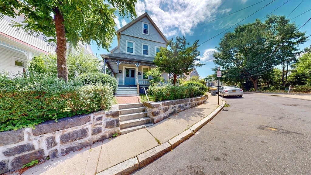
32 Thornton St Unit 2
Boston, MA 02119
2 Weeks Ago
Favorites
32 Thornton St Unit 2

Favorites
Check Back Soon for Upcoming Availability
| Beds | Baths | Average SF |
|---|---|---|
| 2 Bedrooms 2 Bedrooms 2 Br | 1 Bath 1 Bath 1 Ba | 1,328 SF |
About This Property
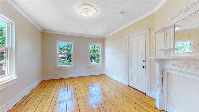
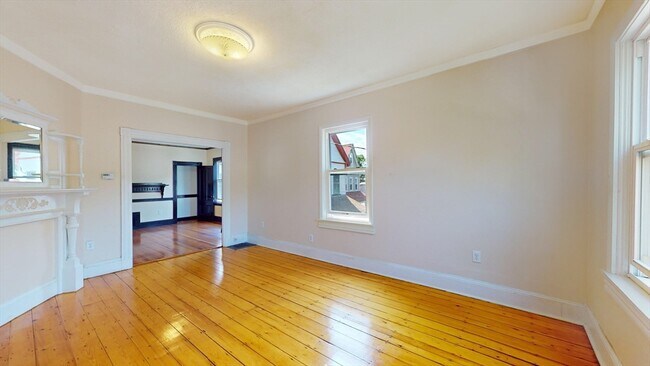
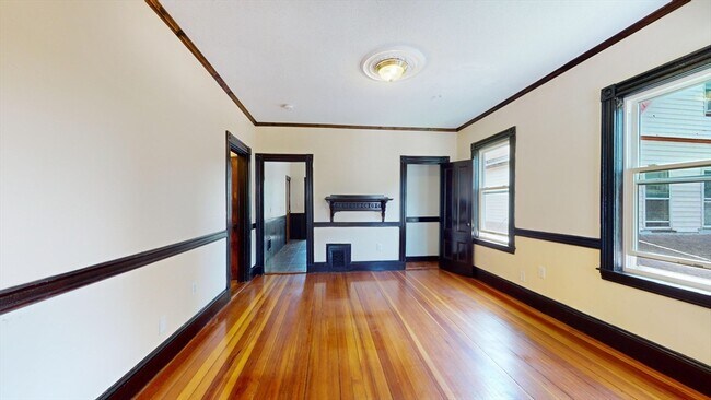
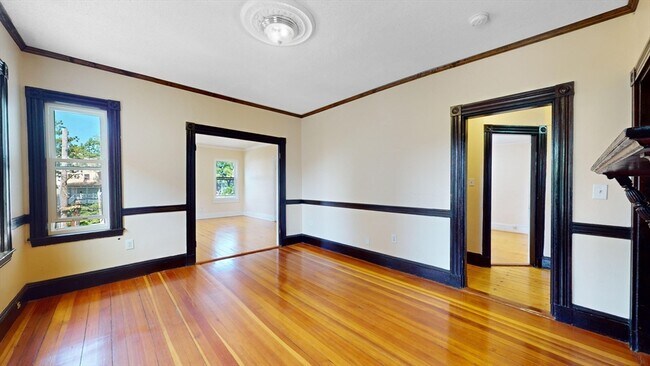
Whether you're relocating to a new city,working from home,or attending school,32 Thornton St is a perfect blend of charm and modern convenience. This spacious sun-drenched 2BR/1BA apartment offers a warm and comfortable living space with 9 foot ceilings,a living room,formal dining room,and eat-in kitchen. It is situated on the second floor of a three-family,owner-occupied home in the historic Fort Hill area of Roxbury,Boston. Just an 8-minute walk from the revitalized Nubian Square,the primary commercial center of Roxbury. This neighborhood is less than 1.5 miles from the heart of the South End and serves as the bus hub for the MBTA's bus rapid transit and Silver Line,providing easy access to neighboring cities,towns,hospitals,colleges,universities,cafes,grocery stores,local shops,and restaurants. Additionally,the Pierre Lallement Bicycle Path runs along the Southwest Corridor Park from Forest Hills to Back Bay. Vacant and easy to show.
32 Thornton St is an apartment community located in Suffolk County and the 02119 ZIP Code.
Location
Get Directions
Twenty minutes southwest of downtown Boston sits Highland Park, a primarily- residential neighborhood full of beautiful historic homes and apartments along tree-lined streets. The community features over a dozen parks and public green spaces, giving all residents easy access to trails, playgrounds, and historic sites wherever they may live.
The local dining scene is quite unique, with several African and Middle Eastern restaurants and cafes around the neighborhood. MBTA rail service on the west side of the neighborhood makes it easy for folks to get around the city for or leisure.
Learn more about living in Highland ParkBelow are rent ranges for similar nearby apartments
| Beds | Average Size | Lowest | Typical | Premium |
|---|---|---|---|---|
| Studio Studio Studio | 3937-3940 Sq Ft | $2,300 | $2,833 | $3,241 |
| 1 Bed 1 Bed 1 Bed | 3357-3362 Sq Ft | $1,700 | $2,912 | $3,834 |
| 2 Beds 2 Beds 2 Beds | 3651-3666 Sq Ft | $2,400 | $3,503 | $5,433 |
| 3 Beds 3 Beds 3 Beds | 5734 Sq Ft | $1,200 | $4,371 | $6,013 |
| 4 Beds 4 Beds 4 Beds | 6301 Sq Ft | $1,330 | $6,195 | $14,000 |
Education
| Colleges & Universities | Distance | ||
|---|---|---|---|
| Colleges & Universities | Distance | ||
| Drive: | 3 min | 1.3 mi | |
| Drive: | 3 min | 1.7 mi | |
| Drive: | 3 min | 1.9 mi | |
| Drive: | 5 min | 2.1 mi |
32 Thornton St Unit 2 is within 3 minutes or 1.3 miles from Wentworth Inst. of Technology. It is also near MCPHS University, Boston and MassArt.
Transportation options available in Boston include Roxbury Crossing Station, located 0.7 mile from 32 Thornton St Unit 2. 32 Thornton St Unit 2 is near General Edward Lawrence Logan International, located 6.3 miles or 13 minutes away.
| Transit / Subway | Distance | ||
|---|---|---|---|
| Transit / Subway | Distance | ||
|
|
Walk: | 12 min | 0.7 mi |
|
|
Walk: | 15 min | 0.8 mi |
|
|
Drive: | 3 min | 1.5 mi |
|
|
Drive: | 3 min | 1.5 mi |
|
|
Drive: | 4 min | 2.0 mi |
| Commuter Rail | Distance | ||
|---|---|---|---|
| Commuter Rail | Distance | ||
| Drive: | 4 min | 1.7 mi | |
|
|
Drive: | 3 min | 1.8 mi |
|
|
Drive: | 4 min | 1.9 mi |
| Drive: | 5 min | 2.2 mi | |
|
|
Drive: | 11 min | 5.5 mi |
| Airports | Distance | ||
|---|---|---|---|
| Airports | Distance | ||
|
General Edward Lawrence Logan International
|
Drive: | 13 min | 6.3 mi |
Time and distance from 32 Thornton St Unit 2.
| Shopping Centers | Distance | ||
|---|---|---|---|
| Shopping Centers | Distance | ||
| Walk: | 15 min | 0.8 mi | |
| Drive: | 3 min | 1.7 mi | |
| Drive: | 4 min | 1.9 mi |
32 Thornton St Unit 2 has 3 shopping centers within 1.9 miles, which is about a 4-minute walk. The miles and minutes will be for the farthest away property.
| Parks and Recreation | Distance | ||
|---|---|---|---|
| Parks and Recreation | Distance | ||
|
Roxbury Heritage State Park
|
Walk: | 9 min | 0.5 mi |
|
Lower Neponset River Trail
|
Drive: | 3 min | 1.8 mi |
|
Franklin Park Zoo
|
Drive: | 4 min | 2.1 mi |
|
Charles River Reservation
|
Drive: | 6 min | 3.0 mi |
|
Coit Observatory
|
Drive: | 7 min | 3.4 mi |
32 Thornton St Unit 2 has 5 parks within 3.4 miles, including Roxbury Heritage State Park, Lower Neponset River Trail, and Franklin Park Zoo.
| Hospitals | Distance | ||
|---|---|---|---|
| Hospitals | Distance | ||
| Drive: | 4 min | 1.3 mi | |
| Drive: | 3 min | 1.4 mi | |
| Drive: | 4 min | 1.6 mi |
32 Thornton St Unit 2 has 3 hospitals within 1.6 miles, the nearest is New England Baptist Hospital which is 1.3 miles away and a 4 minute drive.
| Military Bases | Distance | ||
|---|---|---|---|
| Military Bases | Distance | ||
| Drive: | 32 min | 16.5 mi |
32 Thornton St Unit 2 is 16.5 miles and a 32 minute drive from Hanscom Air Force Base.
You May Also Like
Similar Rentals Nearby


What Are Walk Score®, Transit Score®, and Bike Score® Ratings?
Walk Score® measures the walkability of any address. Transit Score® measures access to public transit. Bike Score® measures the bikeability of any address.
What is a Sound Score Rating?
A Sound Score Rating aggregates noise caused by vehicle traffic, airplane traffic and local sources

32 Thornton St
Boston, MA 02119