
$3,100
Total Monthly Price
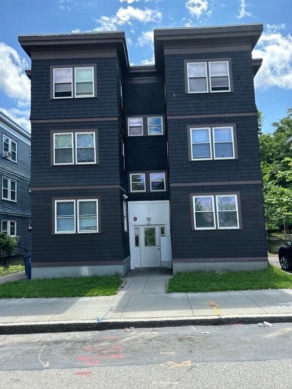
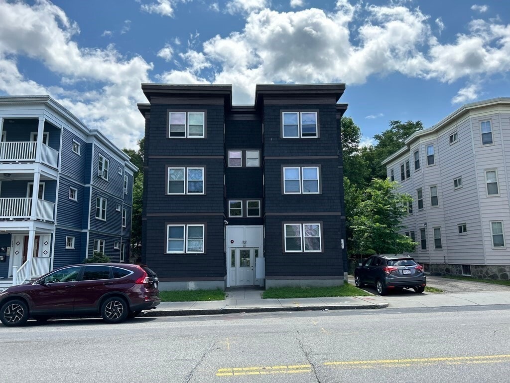
305 Cummins Hwy Unit 3L
Boston, MA 02131
Today
Favorites
781-760-0332
-
Bedrooms
3
-
Bathrooms
1
-
Square Feet
1,000 sq ft
-
Available
Available Now
Highlights
- Fenced Yard
- Enclosed Patio or Porch
- No Cooling
- Heating System Uses Natural Gas
305 Cummins Hwy Unit 3L

Favorites
About This Home
$3,100 deposit,
Available Now
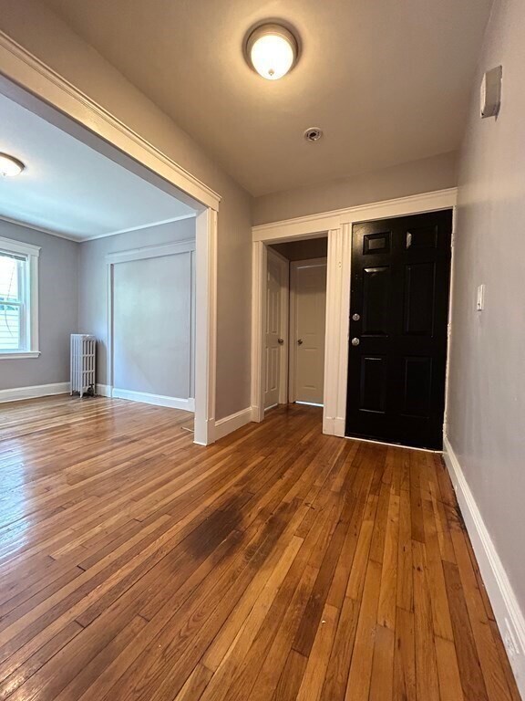
This well-maintained 3-bedroom,1-bath apartment is located on the third floor of a residential building on Cummins Highway in Roslindale. The unit offers convenient access to local schools,restaurants,religious centers,and fitness facilities. Public transportation is easily accessible,with three bus stops nearby on Hyde Park Avenue and one directly in front of the building. Residents will enjoy close proximity to neighborhood amenities,including Walgreens,Stop & Shop,America’s Food Market,and a variety of popular cafés and restaurants. Cats ($50 per month) and dogs ($100 per month) are welcome. The unit is move-in ready,and an application with approval is required. MLS# 73387460
305 Cummins Hwy is an apartment community located in Suffolk County and the 02131 ZIP Code.
* Price shown is total price based on community-supplied monthly required fees. Excludes user-selected optional fees and variable or usage-based fees and required charges due at or prior to move-in or at move-out. Price, availability, fees, and any applicable rent special are subject to change without notice.
* Square footage definitions vary. Displayed square footage is approximate.
Home Details
Bedrooms and Bathrooms
1 Full Bathroom
3 Bedrooms
Home Design
Apartment
Entry on the 3rd floor
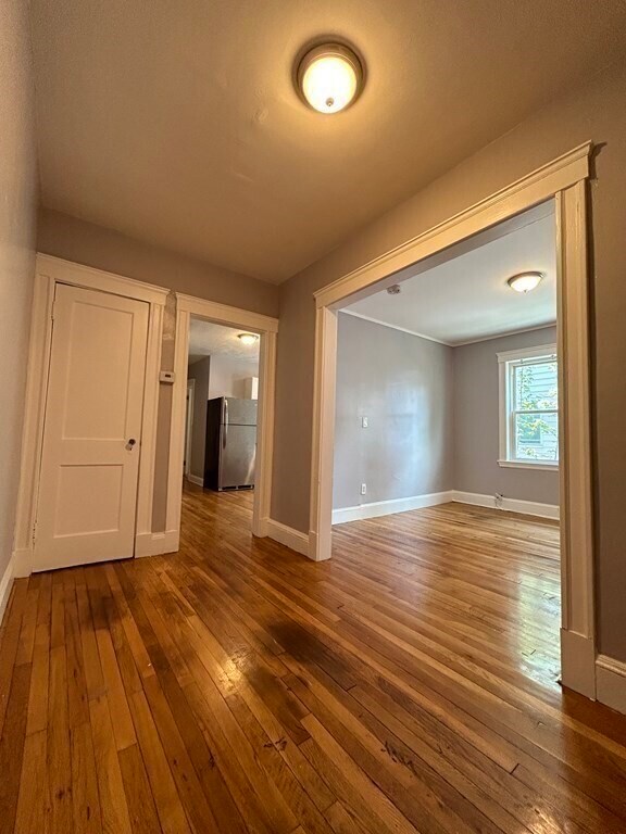
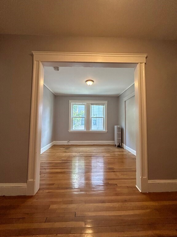
Interior Spaces
1,000 Sq Ft Home
Kitchen
ENERGY STAR Qualified Refrigerator
Listing and Financial Details
Security Deposit $3,100
12 Month Lease Term
Assessor Parcel Number 1386975
Rent includes hot water, water
Lot Details
999 Sq Ft Lot
Fenced Yard
Outdoor Features
Enclosed Patio or Porch
Utilities
No Cooling
Heating System Uses Natural Gas
Community Details
Overview
No Home Owners Association
Pet Policy
Pets Allowed
Fees and Policies
The fees below are based on community-supplied data and may exclude additional fees and utilities.
- Dogs Allowed
-
Fees not specified
- Cats Allowed
-
Fees not specified
Contact
- Listed by Jessica Dejesus Acevedo | Keller Williams Realty Boston Northwest
- Phone Number
-
Source
 MLS Property Information Network
The property listing data and information set forth herein were provided to MLS Property Information Network, Inc. from third party sources, including sellers, lessors and public records, and were compiled by MLS Property Information Network, Inc. The property listing data and information are for the personal, non-commercial use of consumers having a good faith interest in purchasing or leasing listed properties of the type displayed to them and may not be used for any purpose other than to identify prospective properties which such consumers may have a good faith interest in purchasing or leasing. MLS Property Information Network, Inc. and its subscribers disclaim any and all representations and warranties as to the accuracy of the property listing data and information set forth herein. All properties are subject to prior sale, change or withdrawal. Copyright © 2025 MLS Property Information Network, Inc. All rights reserved.
Location
Get Directions
Amenities
- Fenced Lot
- Porch
Lower Washington-Mount Hope is a walkable neighborhood about eight miles south of Boston via Interstate 93 or public transit. Despite this area’s dense population, Lower Washington-Mount Hope has many wooded areas, and large parks like Bussey Brook Meadow and Franklin Park surround the neighborhood. Along with residential neighborhoods, a few shops and eateries can be found in town along American Legion Highway. Many residents travel to the western corner of town to get to the shopping plaza off Corinth Street for all the necessities. The western part of the neighborhood is also where most of the rentals in this area are located. Apartments, condos, and townhomes ranging from moderately priced to luxury can be found here.
Learn more about living in Lower Washington-Mount Hope
Education
| Colleges & Universities | Distance | ||
|---|---|---|---|
| Colleges & Universities | Distance | ||
| Drive: | 8 min | 3.4 mi | |
| Drive: | 8 min | 4.5 mi | |
| Drive: | 9 min | 4.9 mi | |
| Drive: | 9 min | 5.0 mi |
305 Cummins Hwy Unit 3L is within 8 minutes or 3.4 miles from Curry College. It is also near Wentworth Inst. of Technology and MCPHS University, Boston.
Transportation options available in Boston include Forest Hills Station, located 1.6 miles from 305 Cummins Hwy Unit 3L. 305 Cummins Hwy Unit 3L is near General Edward Lawrence Logan International, located 9.8 miles or 19 minutes away.
| Transit / Subway | Distance | ||
|---|---|---|---|
| Transit / Subway | Distance | ||
|
|
Drive: | 3 min | 1.6 mi |
|
|
Drive: | 3 min | 1.8 mi |
|
|
Drive: | 5 min | 2.4 mi |
|
|
Drive: | 4 min | 2.5 mi |
|
|
Drive: | 5 min | 2.5 mi |
| Commuter Rail | Distance | ||
|---|---|---|---|
| Commuter Rail | Distance | ||
|
|
Drive: | 3 min | 1.1 mi |
| Drive: | 3 min | 1.5 mi | |
|
|
Drive: | 3 min | 1.6 mi |
|
|
Drive: | 5 min | 1.9 mi |
|
|
Drive: | 5 min | 2.4 mi |
| Airports | Distance | ||
|---|---|---|---|
| Airports | Distance | ||
|
General Edward Lawrence Logan International
|
Drive: | 19 min | 9.8 mi |
Time and distance from 305 Cummins Hwy Unit 3L.
| Shopping Centers | Distance | ||
|---|---|---|---|
| Shopping Centers | Distance | ||
| Walk: | 7 min | 0.4 mi | |
| Walk: | 10 min | 0.6 mi | |
| Walk: | 18 min | 1.0 mi |
305 Cummins Hwy Unit 3L has 3 shopping centers within 1.0 mile, which is about a 18-minute walk. The miles and minutes will be for the farthest away property.
| Parks and Recreation | Distance | ||
|---|---|---|---|
| Parks and Recreation | Distance | ||
|
Mass Audubon's Boston Nature Center and Wildlife Sanctuary
|
Drive: | 3 min | 1.3 mi |
|
Arnold Arboretum of Harvard University
|
Drive: | 5 min | 2.0 mi |
|
Stony Brook Reservation
|
Drive: | 6 min | 2.7 mi |
|
Franklin Park Zoo
|
Drive: | 7 min | 3.8 mi |
|
Lower Neponset River Trail
|
Drive: | 7 min | 3.9 mi |
305 Cummins Hwy Unit 3L has 5 parks within 3.9 miles, including Mass Audubon's Boston Nature Center and Wildlife Sanctuary, Arnold Arboretum of Harvard University, and Stony Brook Reservation.
| Hospitals | Distance | ||
|---|---|---|---|
| Hospitals | Distance | ||
| Drive: | 7 min | 2.7 mi | |
| Drive: | 6 min | 2.9 mi | |
| Drive: | 5 min | 3.1 mi |
305 Cummins Hwy Unit 3L has 3 hospitals within 3.1 miles, the nearest is Bournewood Hospital which is 2.7 miles away and a 7 minute drive.
| Military Bases | Distance | ||
|---|---|---|---|
| Military Bases | Distance | ||
| Drive: | 30 min | 15.7 mi |
305 Cummins Hwy Unit 3L is 15.7 miles and a 30 minute drive from US Military Reservation.
You May Also Like
-
605 Concord at Fresh Pond
605 Concord Ave
Cambridge, MA 02138
$5,600 - $5,700 Plus Fees
3 Br 7.7 mi
-
The Wyeth
120-124 Rindge Ave
Cambridge, MA 02140
Call for Rent
3-4 Br 12 Month Lease 7.8 mi
-
The 305, A Broadstone Community
305 Winter St
Waltham, MA 02451
$4,809 - $5,523 Total Monthly Price
3 Br 10.9 mi
Similar Rentals Nearby
-
-
-
-
Total Monthly Price New
$9,190 - $9,340
Total Monthly PriceBase Rent$9,190 - $9,340Utilities & EssentialsVariesTotal Monthly Price$9,190 - $9,34012 Month Lease3 Beds
1 Month FreePets Allowed Fitness Center Dishwasher Refrigerator Kitchen In Unit Washer & Dryer
-
-
-
Total Monthly Price New
$7,408 - $7,418
Total Monthly PriceBase Rent$7,398 - $7,408Required Monthly Fees$10Total Monthly Price$7,408 - $7,4183 Beds
SpecialsPets Allowed Fitness Center In Unit Washer & Dryer Balcony High-Speed Internet Stainless Steel Appliances
-
-
-
Total Monthly Price New
$9,310 - $9,325
Total Monthly PriceBase Rent$9,295 - $9,310Required Monthly Fees$15Total Monthly Price$9,310 - $9,3253 Beds
SpecialsPets Allowed Fitness Center Pool Kitchen In Unit Washer & Dryer Walk-In Closets


What Are Walk Score®, Transit Score®, and Bike Score® Ratings?
Walk Score® measures the walkability of any address. Transit Score® measures access to public transit. Bike Score® measures the bikeability of any address.
What is a Sound Score Rating?
A Sound Score Rating aggregates noise caused by vehicle traffic, airplane traffic and local sources
305 Cummins Hwy
Boston, MA 02131