
$3,000
/ Month
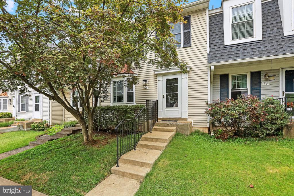
21 Wyatt Ct
Sterling, VA 20165
Today
Favorites
703-261-9190
-
Bedrooms
3
-
Bathrooms
3.5
-
Square Feet
--
-
Available
Available Aug 23
Highlights
- Fitness Center
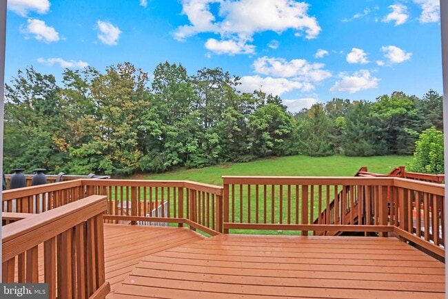
- View of Trees or Woods
- Open Floorplan
- Colonial Architecture
- Clubhouse
- Recreation Room
21 Wyatt Ct

Favorites
About This Home
Available Aug 23
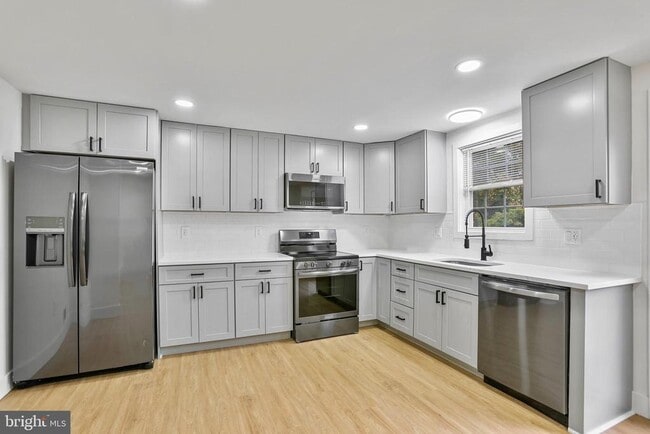
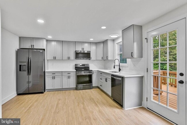
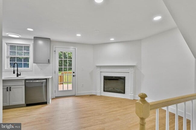
Top-to-bottom remodel in August of 2025 - everything is new. This is a light, bright, open and clean 3-level townhome with 3.5 bathrooms, 3 bedrooms, living room, dining room, country kitchen with fireplace, rear deck, and a fully finished basement. The lower level has a recreation room that walks out to the back yard, a full bathroom, and a spacious utility room with full sized washer and dryer. 2 parking spaces (8 & *8)! Non-smokers only. Pets on a case-by-case basis.
21 Wyatt Ct is a townhome located in Loudoun County and the 20165 ZIP Code. This area is served by the Loudoun County Public Schools attendance zone.
* Price shown is base rent and may not include non-optional fees and utilities. Price, availability, fees, and any applicable rent special are subject to change without notice.
* Square footage definitions vary. Displayed square footage is approximate.
Home Details
Home Type
Interior Unit Townhome
Year Built
Built in 1984 | Remodeled in 2025
Bedrooms and Bathrooms
Walk-In Closet
Bathtub with Shower
En-Suite Primary Bedroom
Walk-in Shower
3.5 Bathrooms
En-Suite Bathroom
3 Bedrooms
Eco-Friendly Details
Energy-Efficient Appliances
Finished Basement
Heated Basement
Walk-Out Basement
Basement Fills Entire Space Under The House
Basement Windows
Laundry in Basement
Connecting Stairway
Interior and Exterior Basement Entry
Flooring
Engineered Wood
Ceramic Tile
Carpet
Home Design
Colonial Architecture
Architectural Shingle Roof
Aluminum Siding
Permanent Foundation
Block Foundation
Poured Concrete
Home Security
Storm Doors
Interior Spaces
Open Floorplan
Recreation Room
Double Pane Windows
Recessed Lighting
Sliding Doors
Combination Dining and Living Room
Utility Room
Window Screens
Six Panel Doors
Electric Fireplace
1,508 Sq Ft Home
Property has 2 Levels
Double Hung Windows
Kitchen
Breakfast Room
Stainless Steel Appliances
Built-In Range
Eat-In Country Kitchen
Electric Oven or Range
Ice Maker
Built-In Microwave
Dishwasher
Disposal
Laundry
Laundry Room
Electric Dryer
Washer
Listing and Financial Details
Security Deposit $3,000
12-Month Min and 24-Month Max Lease Term
Available 8/4/25
$50 Application Fee
Assessor Parcel Number 028372373000
Tenant pays for cable TV, electricity, internet, minor interior maintenance, light bulbs/filters/fuses/alarm care, sewer, all utilities
The owner pays for association fees, common area maintenance, management, pest control, snow removal, real estate taxes, trash collection
Rent includes common area maintenance, community center, hoa/condo fee, insurance, parking, pool maintenance, recreation facility, sewer, taxes, trash removal
$250 Repair Deductible
No Smoking Allowed
Residential Lease
Lot Details
1,742 Sq Ft Lot
Backs to Trees or Woods
West Facing Home
Property is in excellent condition
Wood Fence
Back Yard Fenced
Panel Fence
Backs To Open Common Area
Parking
2 Assigned Parking Spaces
On-Street Parking
Assigned parking located at #8&8
Schools
Countryside Elementary School
River Bend Middle School
Potomac Falls High School
Utilities
Programmable Thermostat
Forced Air Heating and Cooling System
Heat Pump System
Electric Water Heater
Underground Utilities
200+ Amp Service
Views
Woods
Garden
Community Details
Amenities
Clubhouse
Community Center
Recreation Room
Common Area
Overview
Property has a Home Owners Association
Countryside Subdivision, Avon Floorplan
Countryside HOA
Association fees include common area maintenance, lawn care front, management, road maintenance, snow removal, taxes, trash
Pet Policy
Pets allowed on a case-by-case basis
Pet Deposit $500
Recreation
Fitness Center
Lap or Exercise Community Pool
Tennis Courts
Baseball Field
Soccer Field
Community Basketball Court
Jogging Path
Community Playground
Bike Trail
Dog Park
Contact
- Listed by Hans Schenk | Samson Properties
- Phone Number
- Contact
-
Source
 Bright MLS, Inc.
Copyright © 2025 Bright MLS, Inc.
Location
Get Directions
Amenities
- Fireplace
- Dishwasher
- Basement
While the name may inspire visions of rolling, green hills and cascading waterfalls, Countryside-Potomac Falls provides much more than a beautiful location for your Sterling apartment. It borders the Potomac River along the Virginia/Maryland line, then extends southward to Highway 7. The neighborhood is flanked by two popular parks: Bles Park and Algonkian Regional Park. Countryside-Potomac Falls is in northeastern Sterling, roughly 26 miles northwest of Washington, DC. With the nearby businesses of Sterling and the action of DC just minutes away, this fantastic area has grown rapidly since it was developed in the mid-1970s.
Taking full advantage of the area's natural beauty, Countryside-Potomac Falls offers several hiking trails, including the Countryside East River Trail, which connects to the Potomac Heritage Trail.
Learn more about living in Countryside-Potomac Falls
Education
| Colleges & Universities | Distance | ||
|---|---|---|---|
| Colleges & Universities | Distance | ||
| Drive: | 5 min | 2.7 mi | |
| Drive: | 6 min | 3.0 mi | |
| Drive: | 7 min | 3.5 mi | |
| Drive: | 47 min | 30.3 mi |
21 Wyatt Ct is within 5 minutes or 2.7 miles from NOVA, Loudoun Campus. It is also near George Mason University and GWU, Virginia Sci. and Tech..
Schools


Public Elementary School
Grades PK-5
636 Students
Attendance Zone
Public Middle School
Grades 6-8
1,160 Students
Attendance Zone
Public High School
Grades 9-12
1,606 Students
Attendance Zone
Private Elementary School
Grades K
30 Students
Nearby
Private Elementary & Middle School
Grades K-8
203 Students
Nearby
Private Elementary & Middle School
Grades PK-8
214 Students
Nearby
Private Elementary, Middle & High School
Grades PK-12
475 Students
Nearby
School data provided by
 The GreatSchools Rating helps parents compare schools within a state based on a variety of school quality indicators and provides a helpful picture of how effectively each school serves all of its students. Ratings are on a scale of 1 (below average) to 10 (above average) and can include test scores, college readiness, academic progress, advanced courses, equity, discipline and attendance data. We also advise parents to visit schools, consider other information on school performance and programs, and consider family needs as part of the school selection process.
View GreatSchools Rating Methodology
Data provided by GreatSchools.org © 2025. All rights reserved.
View GreatSchools Rating Methodology
Data provided by GreatSchools.org © 2025. All rights reserved.
Transportation options available in Sterling include Ashburn, Silver Line Center Platform, located 6.7 miles from 21 Wyatt Ct. 21 Wyatt Ct is near Washington Dulles International, located 8.9 miles or 17 minutes away, and Ronald Reagan Washington Ntl, located 29.9 miles or 47 minutes away.
| Transit / Subway | Distance | ||
|---|---|---|---|
| Transit / Subway | Distance | ||
| Drive: | 12 min | 6.7 mi | |
| Drive: | 12 min | 7.3 mi | |
| Drive: | 13 min | 7.9 mi | |
| Drive: | 18 min | 11.1 mi | |
| Drive: | 18 min | 11.5 mi |
| Commuter Rail | Distance | ||
|---|---|---|---|
| Commuter Rail | Distance | ||
|
Dickerson Marc Eb
|
Drive: | 48 min | 29.3 mi |
|
|
Drive: | 57 min | 33.2 mi |
|
|
Drive: | 57 min | 38.2 mi |
|
|
Drive: | 60 min | 39.3 mi |
| Drive: | 61 min | 39.3 mi |
| Airports | Distance | ||
|---|---|---|---|
| Airports | Distance | ||
|
Washington Dulles International
|
Drive: | 17 min | 8.9 mi |
|
Ronald Reagan Washington Ntl
|
Drive: | 47 min | 29.9 mi |
Time and distance from 21 Wyatt Ct.
| Shopping Centers | Distance | ||
|---|---|---|---|
| Shopping Centers | Distance | ||
| Drive: | 3 min | 1.3 mi | |
| Drive: | 4 min | 1.7 mi | |
| Drive: | 4 min | 2.1 mi |
21 Wyatt Ct has 3 shopping centers within 2.1 miles, which is about a 4-minute drive. The miles and minutes will be for the farthest away property.
| Parks and Recreation | Distance | ||
|---|---|---|---|
| Parks and Recreation | Distance | ||
|
Claude Moore Park
|
Drive: | 7 min | 3.1 mi |
|
Washington & Old Dominion Railroad Trail
|
Drive: | 7 min | 3.5 mi |
|
Algonkian Regional Park
|
Drive: | 12 min | 4.3 mi |
|
Red Rock Wilderness Regional Park
|
Drive: | 14 min | 8.2 mi |
|
Lake Newport
|
Drive: | 16 min | 8.7 mi |
21 Wyatt Ct has 5 parks within 8.7 miles, including Claude Moore Park, Washington & Old Dominion Railroad Trail, and Algonkian Regional Park.
| Hospitals | Distance | ||
|---|---|---|---|
| Hospitals | Distance | ||
| Drive: | 8 min | 4.7 mi | |
| Drive: | 15 min | 8.4 mi | |
| Drive: | 22 min | 14.5 mi |
21 Wyatt Ct has 3 hospitals within 14.5 miles, the nearest is Inova Loudoun Hospital which is 4.7 miles away and a 8 minute drive.
| Military Bases | Distance | ||
|---|---|---|---|
| Military Bases | Distance | ||
| Drive: | 44 min | 27.3 mi |
21 Wyatt Ct is 27.3 miles and a 44 minute drive from Naval Observatory.
You May Also Like
Similar Rentals Nearby


What Are Walk Score®, Transit Score®, and Bike Score® Ratings?
Walk Score® measures the walkability of any address. Transit Score® measures access to public transit. Bike Score® measures the bikeability of any address.
What is a Sound Score Rating?
A Sound Score Rating aggregates noise caused by vehicle traffic, airplane traffic and local sources

21 Wyatt Ct
Sterling, VA 20165