
$4,995 - $5,600
Plus Fees4 Beds
2 Months Free
Pets Allowed Balcony Range Patio Stainless Steel Appliances EV Charging


| Beds | Baths | Average SF |
|---|---|---|
| 5 Bedrooms 5 Bedrooms 5 Br | 2 Baths 2 Baths 2 Ba | 9,999 SF |
The fees below are based on community-supplied data and may exclude additional fees and utilities.
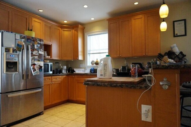
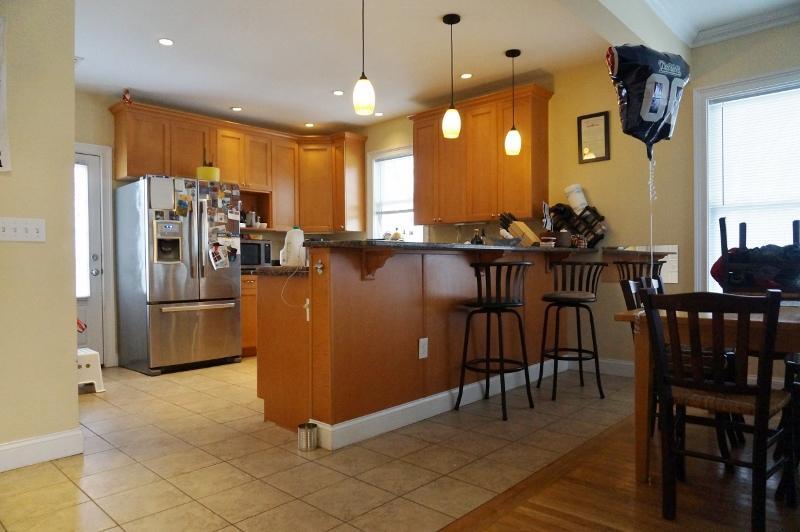
2 Floors 2 Baths Laundry in Unit 2 Parking Spots Included Updated Eat in Kitchen Hardwood Floors Very Sunny 9/1/21 Near the T Mike Swann Keller Williams Realty
2 High Rock Way is an apartment community located in Suffolk County and the 02134 ZIP Code.
Washer/Dryer
Hardwood Floors
Granite Countertops
Eat-in Kitchen
Saint Elizabeth’s is a Brighton neighborhood situated about 10 miles away from Boston. Thanks to Saint Elizabeth’s top border sitting on Highway 20, commuting in and out of Brighton is easy. Some residents travel by car, but buses and railways make commuting via public transportation a breeze.
The neighborhood’s best amenities are two world-renowned hospitals, Saint Elizabeth’s Medical Center and Franciscan Children’s, that sit on the edge of town. Other great amenities of Saint Elizabeth’s include many local parks like Ringer Playground and Chestnut Hill Reservoir, which has great trails and greenspace. This neighborhood is also equipped with cozy coffee shops, restaurants serving international and American classics, and shopping plazas with grocers and convenience stores.
Saint Elizabeth’s has several rental options ranging from apartments to single-family homes.
Learn more about living in St Elizabeth's| Beds | Average Size | Lowest | Typical | Premium |
|---|---|---|---|---|
| Studio Studio Studio | 5455 Sq Ft | $1,700 | $2,243 | $5,650 |
| 1 Bed 1 Bed 1 Bed | 4455-4456 Sq Ft | $1,000 | $2,544 | $10,000 |
| 2 Beds 2 Beds 2 Beds | 3617 Sq Ft | $1,680 | $3,233 | $7,194 |
| 3 Beds 3 Beds 3 Beds | 4278 Sq Ft | $1,280 | $3,892 | $6,889 |
| 4 Beds 4 Beds 4 Beds | 4291 Sq Ft | $900 | $5,492 | $17,000 |
| Colleges & Universities | Distance | ||
|---|---|---|---|
| Colleges & Universities | Distance | ||
| Drive: | 4 min | 1.7 mi | |
| Drive: | 6 min | 1.7 mi | |
| Drive: | 6 min | 2.1 mi | |
| Drive: | 5 min | 2.2 mi |
Transportation options available in Boston include Allston Street Station, located 0.3 mile from 2 High Rock Way Unit 2. 2 High Rock Way Unit 2 is near General Edward Lawrence Logan International, located 8.4 miles or 15 minutes away.
| Transit / Subway | Distance | ||
|---|---|---|---|
| Transit / Subway | Distance | ||
|
|
Walk: | 4 min | 0.3 mi |
|
|
Walk: | 5 min | 0.3 mi |
|
|
Walk: | 7 min | 0.4 mi |
|
|
Walk: | 8 min | 0.4 mi |
|
|
Walk: | 13 min | 0.7 mi |
| Commuter Rail | Distance | ||
|---|---|---|---|
| Commuter Rail | Distance | ||
|
|
Drive: | 5 min | 2.5 mi |
|
|
Drive: | 8 min | 3.4 mi |
|
|
Drive: | 7 min | 3.5 mi |
|
|
Drive: | 11 min | 4.3 mi |
| Drive: | 10 min | 4.7 mi |
| Airports | Distance | ||
|---|---|---|---|
| Airports | Distance | ||
|
General Edward Lawrence Logan International
|
Drive: | 15 min | 8.4 mi |
Time and distance from 2 High Rock Way Unit 2.
| Shopping Centers | Distance | ||
|---|---|---|---|
| Shopping Centers | Distance | ||
| Walk: | 9 min | 0.5 mi | |
| Walk: | 14 min | 0.8 mi | |
| Drive: | 3 min | 1.1 mi |
| Parks and Recreation | Distance | ||
|---|---|---|---|
| Parks and Recreation | Distance | ||
|
John Fitzgerald Kennedy National Historic Site
|
Drive: | 3 min | 1.3 mi |
|
Chestnut Hill Reservation
|
Drive: | 4 min | 1.6 mi |
|
Coit Observatory
|
Drive: | 5 min | 2.1 mi |
|
Frederick Law Olmsted National Historic Site
|
Drive: | 7 min | 2.5 mi |
|
Longfellow National Historic Site
|
Drive: | 7 min | 3.0 mi |
| Hospitals | Distance | ||
|---|---|---|---|
| Hospitals | Distance | ||
| Walk: | 8 min | 0.5 mi | |
| Walk: | 10 min | 0.6 mi | |
| Drive: | 2 min | 1.1 mi |
| Military Bases | Distance | ||
|---|---|---|---|
| Military Bases | Distance | ||
| Drive: | 26 min | 13.4 mi | |
| Drive: | 25 min | 14.2 mi |
$4,995 - $5,600
Plus Fees4 Beds
Pets Allowed Balcony Range Patio Stainless Steel Appliances EV Charging
What Are Walk Score®, Transit Score®, and Bike Score® Ratings?
Walk Score® measures the walkability of any address. Transit Score® measures access to public transit. Bike Score® measures the bikeability of any address.
What is a Sound Score Rating?
A Sound Score Rating aggregates noise caused by vehicle traffic, airplane traffic and local sources
2 High Rock Way
Boston, MA 02134


