16 High St
16 High St,
Somerville,
MA
02144
2 Weeks Ago
Favorites
16 High St

Favorites
Check Back Soon for Upcoming Availability
About 16 High St Somerville, MA 02144
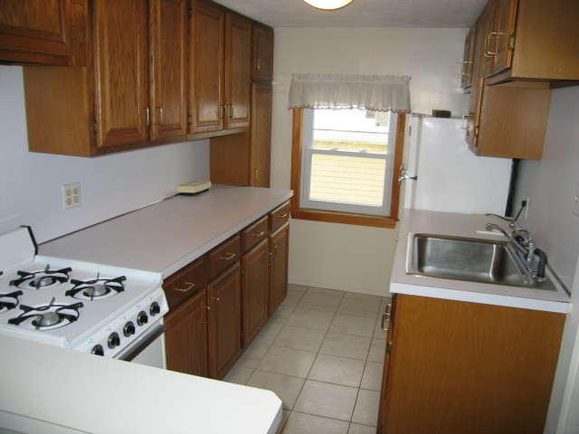
Excellent deal here. On the top floor of a three family home. WW carpet throughout and enclosed porch. Walk to Davis Square in about 20 minutes. (Reference #129010)
16 High St is an apartment community located in Middlesex County and the 02144 ZIP Code.
Apartment Features
- Carpet
Fees and Policies
Details
Lease Options
-
12 Months
Location
Get Directions
Attractive homes and tree-shaded sidewalks line the streets of West Somerville, a mainly-residential suburban community along Alewife Brook Parkway. The east side of the neighborhood borders the Tufts University campus, making it an excellent location for students, faculty, and staff to find apartments. Large chain grocery stores and corner markets in the community give residents numerous convenient options for grabbing their everyday necessities.
While the close proximity to the university does attract renters from the collegiate demographic, there is plenty for families to appreciate as well: multiple public schools can be found within and around the neighborhood, and the Dilboy sports facilities on the west side are perfect venues for all-ages fun.
Learn more about living in West SomervilleBelow are rent ranges for similar nearby apartments
Amenities
- Carpet
Education
| Colleges & Universities | Distance | ||
|---|---|---|---|
| Colleges & Universities | Distance | ||
| Drive: | 3 min | 1.2 mi | |
| Drive: | 5 min | 2.3 mi | |
| Drive: | 6 min | 2.7 mi | |
| Drive: | 7 min | 3.4 mi |
16 High St is within 3 minutes or 1.2 miles from Tufts Univ., Medford. It is also near Lesley University, Porter and Lesley University.
Transportation options available in Somerville include Medford/Tufts, located 1.4 miles from 16 High St. 16 High St is near General Edward Lawrence Logan International, located 8.8 miles or 17 minutes away.
| Transit / Subway | Distance | ||
|---|---|---|---|
| Transit / Subway | Distance | ||
| Drive: | 3 min | 1.4 mi | |
|
|
Drive: | 3 min | 1.6 mi |
| Drive: | 4 min | 1.7 mi | |
|
|
Drive: | 4 min | 1.8 mi |
|
|
Drive: | 5 min | 2.1 mi |
| Commuter Rail | Distance | ||
|---|---|---|---|
| Commuter Rail | Distance | ||
|
|
Drive: | 2 min | 1.1 mi |
|
|
Drive: | 6 min | 2.6 mi |
|
|
Drive: | 6 min | 3.2 mi |
|
|
Drive: | 7 min | 3.4 mi |
|
|
Drive: | 7 min | 3.6 mi |
| Airports | Distance | ||
|---|---|---|---|
| Airports | Distance | ||
|
General Edward Lawrence Logan International
|
Drive: | 17 min | 8.8 mi |
Time and distance from 16 High St.
| Shopping Centers | Distance | ||
|---|---|---|---|
| Shopping Centers | Distance | ||
| Drive: | 5 min | 2.1 mi | |
| Drive: | 6 min | 2.6 mi | |
| Drive: | 5 min | 2.7 mi |
16 High St has 3 shopping centers within 2.7 miles, which is about a 5-minute drive. The miles and minutes will be for the farthest away property.
| Parks and Recreation | Distance | ||
|---|---|---|---|
| Parks and Recreation | Distance | ||
|
Mystic River Reservation
|
Drive: | 5 min | 2.8 mi |
|
Mineralogical and Geological Museum
|
Drive: | 7 min | 3.0 mi |
|
Harvard Museum of Natural History
|
Drive: | 7 min | 3.0 mi |
|
Harvard-Smithsonian Center for Astrophysics
|
Drive: | 6 min | 3.1 mi |
|
Longfellow National Historic Site
|
Drive: | 7 min | 3.4 mi |
16 High St has 5 parks within 3.4 miles, including Harvard-Smithsonian Center for Astrophysics, Mystic River Reservation, and Harvard Museum of Natural History.
| Hospitals | Distance | ||
|---|---|---|---|
| Hospitals | Distance | ||
| Drive: | 6 min | 3.5 mi | |
| Drive: | 8 min | 3.8 mi | |
| Drive: | 9 min | 4.6 mi |
16 High St has 3 hospitals within 4.6 miles, the nearest is Mount Auburn Hospital which is 3.5 miles away and a 6 minute drive.
| Military Bases | Distance | ||
|---|---|---|---|
| Military Bases | Distance | ||
| Drive: | 19 min | 10.4 mi | |
| Drive: | 32 min | 17.8 mi |
16 High St is 10.4 miles from Hanscom Air Force Base, and is convenient to other military bases, including US Military Reservation.
You May Also Like
Similar Rentals Nearby


What Are Walk Score®, Transit Score®, and Bike Score® Ratings?
Walk Score® measures the walkability of any address. Transit Score® measures access to public transit. Bike Score® measures the bikeability of any address.
What is a Sound Score Rating?
A Sound Score Rating aggregates noise caused by vehicle traffic, airplane traffic and local sources