

$1,900
/ Month
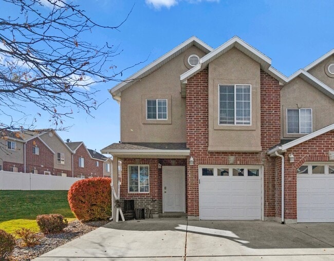
10542 Sage Flats Way
South Jordan, UT 84009
Today
|
Edit
Favorites
801-673-0959
-
Bedrooms
3
-
Bathrooms
2
-
Square Feet
1,400 sq ft
-
Available
Available Feb 1
10542 Sage Flats Way

Favorites
About This Home
Available Feb 1
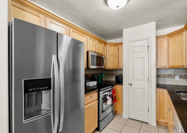
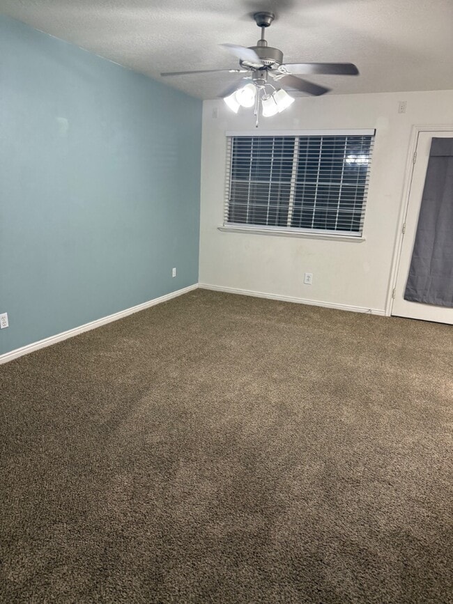
An end unit townhouse located in a great South Jordan neighborhood with easy access to Bangerter Highway. The interior features a large master suite with walk in closet, a spacious family room, and a recently remodeled kitchen. You'll also enjoy the convenience of an upstairs laundry room. The backyard patio is fully fenced in, allowing for privacy, but because this is an end unit you'll have easy access to a large side yard. 1 car garage + a rare 2 driveway/off-street parking spots. HOA offers a clubhouse, swimming pool, snow shoveling, and yard maintenance. Conveniently located near the District, Costco, and Daybreak with all it's shopping, parks and walking trails. Google Fiber available. Community swimming pool. Close to Bangerter.
10542 Sage Flats Way is a townhome located in Salt Lake County and the 84009 ZIP Code. This area is served by the Jordan District attendance zone.
* Price shown is base rent. Excludes user-selected optional fees and variable or usage-based fees and required charges due at or prior to move-in or at move-out. Price, availability, fees, and any applicable rent special are subject to change without notice.
* Square footage definitions vary. Displayed square footage is approximate.
Contact
- Listed by | Bryce Abplanalp | Pride Property Realty
- Phone Number
- Contact
Location
Get Directions
In the Salt Lake Valley, between the Wasatch and Oquirrh Mountains, sits South Jordan. A suburb located just 20 minutes south of Downtown Salt Lake City, South Jordan is committed to preserving natural beauty.
With 27 municipal parks and playgrounds, there is no shortage of open space to engage in all kinds of outdoor activities. Golfers have their choice of practicing their game at Glenmoor Golf Course or Mulligan’s Golf and Games. Hikers can try out 11 trails with stunning mountain views. History enthusiasts flock to the Gale Center of History and Culture to learn about the history of South Jordan and Americana.
South Jordan is accessible to I-15, the UTA bus system, two TRAX Red Line stations, and one commuter rail stop on the FrontRunner. Salt Lake City International Airport is less than 30 minutes away, making travel plans from South Jordan simple.
Learn more about living in South Jordan
Education
| Colleges & Universities | Distance | ||
|---|---|---|---|
| Colleges & Universities | Distance | ||
| Drive: | 10 min | 4.8 mi | |
| Drive: | 18 min | 10.6 mi | |
| Drive: | 18 min | 10.9 mi | |
| Drive: | 29 min | 19.4 mi |
10542 Sage Flats Way is within 10 minutes or 4.8 miles from Rosman UHS. It is also near Salt Lake Community College and University of Phoenix, Utah.
Schools


Public Elementary School
Grades PK-6
517 Students
Nearby
Public Elementary School
Grades K-6
790 Students
Attendance Zone
Public Middle School
Grades 7-9
1,118 Students
Attendance Zone
Public High School
Grades 10-12
2,482 Students
Attendance Zone
Private Elementary, Middle & High School
Grades PK-12
209 Students
Nearby
Private Elementary & Middle School
Grades PK-8
158 Students
Nearby
School data provided by
 The GreatSchools Rating helps parents compare schools within a state based on a variety of school quality indicators and provides a helpful picture of how effectively each school serves all of its students. Ratings are on a scale of 1 (below average) to 10 (above average) and can include test scores, college readiness, academic progress, advanced courses, equity, discipline and attendance data. We also advise parents to visit schools, consider other information on school performance and programs, and consider family needs as part of the school selection process.
View GreatSchools Rating Methodology
Data provided by GreatSchools.org © 2026. All rights reserved.
View GreatSchools Rating Methodology
Data provided by GreatSchools.org © 2026. All rights reserved.
Transportation options available in South Jordan include South Jordan Parkway Station, located 2.7 miles from 10542 Sage Flats Way. 10542 Sage Flats Way is near Salt Lake City International, located 16.1 miles or 25 minutes away, and Provo Municipal, located 35.8 miles or 49 minutes away.
| Transit / Subway | Distance | ||
|---|---|---|---|
| Transit / Subway | Distance | ||
|
|
Drive: | 6 min | 2.7 mi |
|
|
Drive: | 8 min | 3.0 mi |
|
|
Drive: | 7 min | 3.2 mi |
|
|
Drive: | 7 min | 3.6 mi |
|
|
Drive: | 10 min | 4.7 mi |
| Commuter Rail | Distance | ||
|---|---|---|---|
| Commuter Rail | Distance | ||
|
|
Drive: | 10 min | 4.8 mi |
|
|
Drive: | 15 min | 9.9 mi |
|
|
Drive: | 23 min | 15.1 mi |
|
|
Drive: | 29 min | 20.2 mi |
|
American Fork Station
|
Drive: | 32 min | 20.6 mi |
| Airports | Distance | ||
|---|---|---|---|
| Airports | Distance | ||
|
Salt Lake City International
|
Drive: | 25 min | 16.1 mi |
|
Provo Municipal
|
Drive: | 49 min | 35.8 mi |
Time and distance from 10542 Sage Flats Way.
| Shopping Centers | Distance | ||
|---|---|---|---|
| Shopping Centers | Distance | ||
| Walk: | 9 min | 0.5 mi | |
| Drive: | 4 min | 2.3 mi | |
| Drive: | 6 min | 2.8 mi |
10542 Sage Flats Way has 3 shopping centers within 2.8 miles, which is about a 6-minute drive. The miles and minutes will be for the farthest away property.
| Parks and Recreation | Distance | ||
|---|---|---|---|
| Parks and Recreation | Distance | ||
|
Conservation Garden Park
|
Drive: | 11 min | 5.7 mi |
|
Dimple Dell Regional Nature Park
|
Drive: | 18 min | 8.8 mi |
|
Wheeler Historic Farm
|
Drive: | 21 min | 11.2 mi |
|
Solitude Mountain Resort
|
Drive: | 24 min | 15.3 mi |
10542 Sage Flats Way has 4 parks within 15.3 miles, including Conservation Garden Park, Dimple Dell Regional Nature Park, and Wheeler Historic Farm.
| Hospitals | Distance | ||
|---|---|---|---|
| Hospitals | Distance | ||
| Drive: | 5 min | 2.7 mi | |
| Drive: | 5 min | 3.5 mi | |
| Drive: | 12 min | 6.5 mi |
10542 Sage Flats Way has 3 hospitals within 6.5 miles, the nearest is Jordan Valley Medical Center which is 2.7 miles away and a 5 minute drive.
| Military Bases | Distance | ||
|---|---|---|---|
| Military Bases | Distance | ||
| Drive: | 25 min | 18.1 mi |
10542 Sage Flats Way is 18.1 miles and a 25 minute drive from Salt Lake City Airport Air Guard Station.
You May Also Like
Similar Rentals Nearby


What Are Walk Score®, Transit Score®, and Bike Score® Ratings?
Walk Score® measures the walkability of any address. Transit Score® measures access to public transit. Bike Score® measures the bikeability of any address.
What is a Sound Score Rating?
A Sound Score Rating aggregates noise caused by vehicle traffic, airplane traffic and local sources

10542 Sage Flats Way
South Jordan, UT 84009