
Isle House
39 Bruton St,
San Francisco, CA 94130
$3,637 - $7,642 Total Monthly Price
Studio - 3 Beds
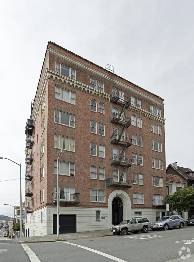

Explore your new home at Presidio Heights Apartments. These apartments are located in San Francisco at 3301 Clay St. in the 94118 area. Come for a visit to see the current floorplan options. Here at this community, the team of leasing professionals will assist you in finding your perfect new apartment. It's time to find your next place. Contact or stop by Presidio Heights Apartments to find out current pricing!
Presidio Heights Apartments is an apartment community located in San Francisco County and the 94118 ZIP Code. This area is served by the San Francisco Unified School District attendance zone.
High Speed Internet Access
Refrigerator
Smoke Free
Heating
An affluent neighborhood in northern San Francisco, Presidio Heights offers family-friendly living with luxury apartments and classic urban townhomes for rent. This upscale neighborhood borders Presidio, a 1,500-acre park that’s a major outdoor recreation hub for the city of San Francisco. Discover forests, miles of trails, a golf course, and gorgeous scenic overlooks of the San Francisco Bay.
At the park, visit the grassy Crissy Field with views of the Golden Gate Bridge, enjoy the sandy banks of Baker Beach, admire historic homes, explore the Walt Disney Family Museum, see a show at the Palace of Fine Arts Theatre, and visit the historic Fort Point.
Public and private schools are available in the area, and the neighborhood is located just north of the University of California San Francisco Laurel Heights campus. Residents have access to public transit through local bus stations and enjoy both walkable and bike-friendly streets.
Learn more about living in Presidio HeightsCompare neighborhood and city base rent averages by bedroom.
| Presidio Heights | San Francisco, CA | |
|---|---|---|
| Studio | $1,609 | $2,513 |
| 1 Bedroom | $2,805 | $3,313 |
| 2 Bedrooms | $3,568 | $4,536 |
| 3 Bedrooms | $2,737 | $5,700 |
| Colleges & Universities | Distance | ||
|---|---|---|---|
| Colleges & Universities | Distance | ||
| Walk: | 15 min | 0.8 mi | |
| Walk: | 19 min | 1.0 mi | |
| Drive: | 7 min | 2.5 mi | |
| Drive: | 8 min | 3.0 mi |


Transportation options available in San Francisco include Van Ness And California, located 1.5 miles from Presidio Heights Apartments. Presidio Heights Apartments is near San Francisco International, located 15.7 miles or 26 minutes away, and Metro Oakland International, located 21.6 miles or 36 minutes away.
| Transit / Subway | Distance | ||
|---|---|---|---|
| Transit / Subway | Distance | ||
|
|
Drive: | 4 min | 1.5 mi |
|
|
Drive: | 4 min | 1.7 mi |
|
|
Drive: | 4 min | 1.8 mi |
| Drive: | 5 min | 1.9 mi | |
| Drive: | 6 min | 2.1 mi |
| Commuter Rail | Distance | ||
|---|---|---|---|
| Commuter Rail | Distance | ||
| Drive: | 10 min | 4.8 mi | |
| Drive: | 15 min | 7.9 mi | |
| Drive: | 21 min | 11.2 mi | |
| Drive: | 21 min | 12.3 mi | |
|
|
Drive: | 25 min | 13.2 mi |
| Airports | Distance | ||
|---|---|---|---|
| Airports | Distance | ||
|
San Francisco International
|
Drive: | 26 min | 15.7 mi |
|
Metro Oakland International
|
Drive: | 36 min | 21.6 mi |
Scores provided by
Traffic
ActiveAirport
CalmBusinesses
ActiveScores provided by
HowLoud What is a Sound Score Rating? A Sound Score Rating aggregates noise caused by vehicle traffic, airplane traffic and local sources. How It WorksTime and distance from Presidio Heights Apartments.
| Shopping Centers | Distance | ||
|---|---|---|---|
| Shopping Centers | Distance | ||
| Walk: | 15 min | 0.8 mi | |
| Drive: | 3 min | 1.3 mi | |
| Drive: | 5 min | 1.9 mi |
| Parks and Recreation | Distance | ||
|---|---|---|---|
| Parks and Recreation | Distance | ||
|
Exploratorium
|
Drive: | 3 min | 1.4 mi |
|
Conservatory of Flowers
|
Drive: | 4 min | 1.7 mi |
|
Buena Vista Park
|
Drive: | 6 min | 1.9 mi |
|
California Academy of Sciences
|
Drive: | 7 min | 2.4 mi |
|
Presidio of San Francisco
|
Drive: | 8 min | 2.8 mi |
| Hospitals | Distance | ||
|---|---|---|---|
| Hospitals | Distance | ||
| Walk: | 12 min | 0.6 mi | |
| Drive: | 3 min | 1.5 mi | |
| Drive: | 5 min | 2.0 mi |
| Military Bases | Distance | ||
|---|---|---|---|
| Military Bases | Distance | ||
| Drive: | 10 min | 3.4 mi | |
| Drive: | 11 min | 3.8 mi | |
| Drive: | 18 min | 7.7 mi |
Pets Allowed Dishwasher Walk-In Closets Balcony Maintenance on site CableReady Elevator
Pets Allowed Fitness Center In Unit Washer & Dryer Stainless Steel Appliances Business Center Package Service Elevator
What Are Walk Score®, Transit Score®, and Bike Score® Ratings?
Walk Score® measures the walkability of any address. Transit Score® measures access to public transit. Bike Score® measures the bikeability of any address.
What is a Sound Score Rating?
A Sound Score Rating aggregates noise caused by vehicle traffic, airplane traffic and local sources.

3301 Clay St
San Francisco, CA 94118


