
Summerwood
21701 Foothill Blvd,
Hayward, CA 94541
$2,099 - $2,740
1-3 Beds

Apply before the end of July 31st., and receive 4 weeks off for the month of September!
Paseo Gardens is an apartment community located in Alameda County and the 94541 ZIP Code. This area is served by the San Lorenzo Unified attendance zone.
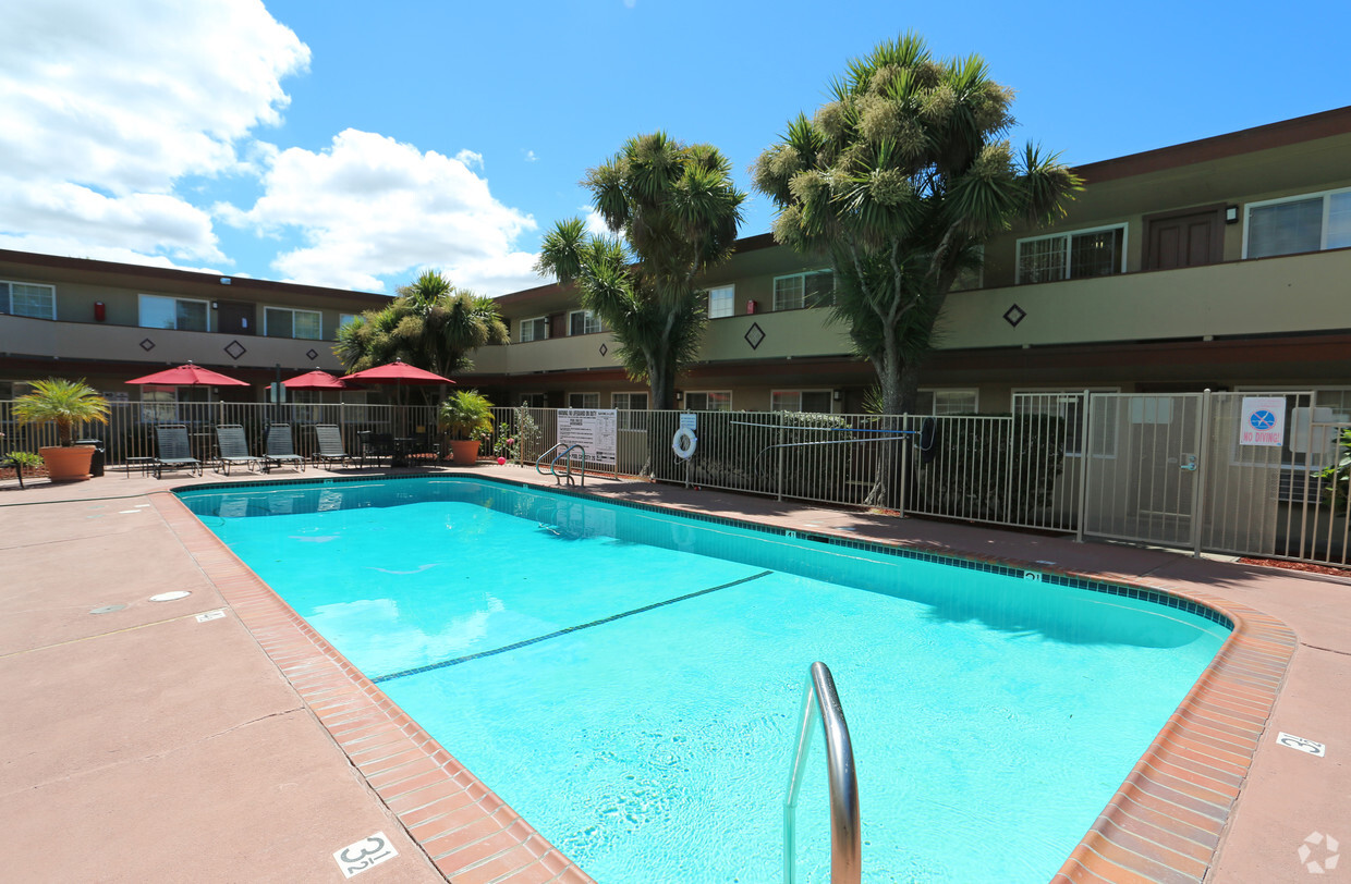
Pool
Laundry Facilities
Controlled Access
Grill
Air Conditioning
Dishwasher
High Speed Internet Access
Walk-In Closets
South of Oakland and north of Hayward lies the dreamily named Cherryland, an unincorporated community of quiet residential streets and lush parks. Clues to its namesake dot the neighborhood's streets, from Cherry Way to Blossom Way. The San Lorenzo Creek connects the area via water to the San Francisco Bay, cementing its place in the greater East Bay region.
Learn more about living in CherrylandCompare neighborhood and city base rent averages by bedroom.
| Cherryland | Hayward, CA | |
|---|---|---|
| Studio | - | $1,950 |
| 1 Bedroom | $1,786 | $2,098 |
| 2 Bedrooms | $2,256 | $2,354 |
| 3 Bedrooms | $2,698 | $2,766 |
| Colleges & Universities | Distance | ||
|---|---|---|---|
| Colleges & Universities | Distance | ||
| Drive: | 10 min | 4.5 mi | |
| Drive: | 11 min | 4.6 mi | |
| Drive: | 17 min | 9.8 mi | |
| Drive: | 38 min | 19.1 mi |


Transportation options available in Hayward include Bay Fair Station, located 1.9 miles from Paseo Gardens. Paseo Gardens is near Metro Oakland International, located 8.0 miles or 12 minutes away, and San Francisco International, located 25.3 miles or 33 minutes away.
| Transit / Subway | Distance | ||
|---|---|---|---|
| Transit / Subway | Distance | ||
|
|
Drive: | 5 min | 1.9 mi |
|
|
Drive: | 6 min | 2.5 mi |
|
|
Drive: | 8 min | 5.1 mi |
|
|
Drive: | 8 min | 5.2 mi |
|
|
Drive: | 13 min | 7.5 mi |
| Commuter Rail | Distance | ||
|---|---|---|---|
| Commuter Rail | Distance | ||
|
|
Drive: | 5 min | 1.8 mi |
| Drive: | 5 min | 1.8 mi | |
|
|
Drive: | 16 min | 12.0 mi |
| Drive: | 18 min | 12.3 mi | |
| Drive: | 19 min | 12.5 mi |
| Airports | Distance | ||
|---|---|---|---|
| Airports | Distance | ||
|
Metro Oakland International
|
Drive: | 12 min | 8.0 mi |
|
San Francisco International
|
Drive: | 33 min | 25.3 mi |
Time and distance from Paseo Gardens.
| Shopping Centers | Distance | ||
|---|---|---|---|
| Shopping Centers | Distance | ||
| Walk: | 14 min | 0.7 mi | |
| Walk: | 16 min | 0.9 mi | |
| Drive: | 3 min | 1.4 mi |
| Parks and Recreation | Distance | ||
|---|---|---|---|
| Parks and Recreation | Distance | ||
|
Don Castro Regional Recreation Area
|
Drive: | 5 min | 3.5 mi |
|
Hayward Regional Shoreline
|
Drive: | 11 min | 3.8 mi |
|
Sulphur Creek Nature Center
|
Drive: | 9 min | 3.9 mi |
|
Lake Chabot Regional Park
|
Drive: | 8 min | 3.9 mi |
|
Cull Canyon Regional Recreation Area
|
Drive: | 10 min | 5.1 mi |
| Hospitals | Distance | ||
|---|---|---|---|
| Hospitals | Distance | ||
| Drive: | 5 min | 2.2 mi | |
| Drive: | 7 min | 4.3 mi | |
| Drive: | 9 min | 5.8 mi |
| Military Bases | Distance | ||
|---|---|---|---|
| Military Bases | Distance | ||
| Drive: | 24 min | 15.4 mi |
Pets Allowed Fitness Center In Unit Washer & Dryer High-Speed Internet Controlled Access EV Charging Rooftop Deck
Pets Allowed Fitness Center In Unit Washer & Dryer High-Speed Internet Controlled Access Concierge Rooftop Deck
What Are Walk Score®, Transit Score®, and Bike Score® Ratings?
Walk Score® measures the walkability of any address. Transit Score® measures access to public transit. Bike Score® measures the bikeability of any address.
What is a Sound Score Rating?
A Sound Score Rating aggregates noise caused by vehicle traffic, airplane traffic and local sources
16929 Meekland Ave
Hayward, CA 94541


