
Avana Southview
4930 Ashley Ln,
Inver Grove Heights, MN 55077
$1,401 - $5,053 Total Monthly Price
Studio - 2 Beds
Bedrooms
2 - 5 bd
Bathrooms
2 - 3.5 ba
Square Feet
842 - 2,966 sq ft
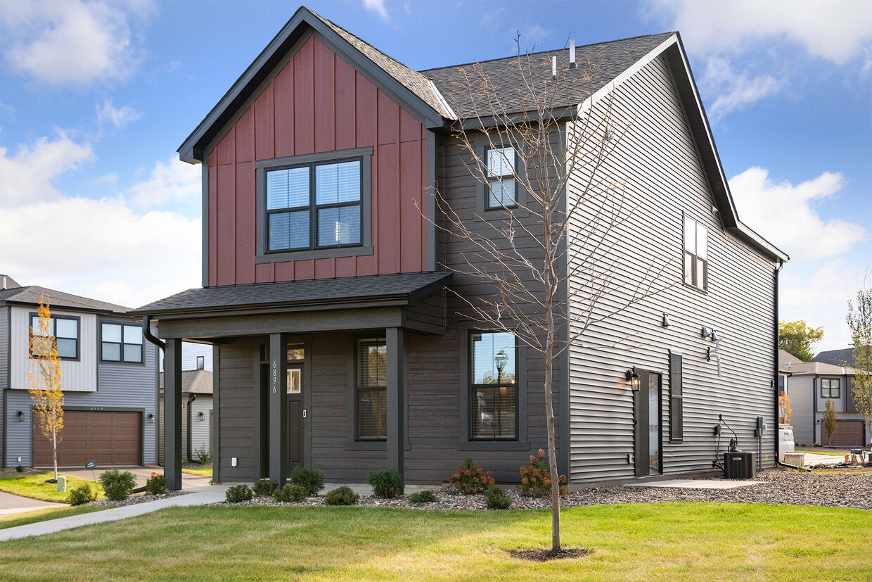
Our sought-after Canvas at Inver Grove Heights offers modern farmhouse-styled single-family homes for an ideal living experience in Inver Grove Heights, Minnesota. Enjoy maintenance-free living with an easy commute to everything the city offers from your front door, including shopping, dining, and local parks. Each welcoming and spacious pet-friendly two, three, four, and five-bedroom home boasts upscale features and finishes, including stone countertops, stainless steel appliances with a gas range, wood-style flooring, smart-home technology, an in-home full-size washer and dryer, an abundance of storage, and basements in select homes. Residents can relax with our community amenities, which include a clubhouse with a fitness center and free weights, an outdoor pool and fire pit, BBQ/Picnic area, and more. Contact Canvas at Inver Grove Heights today! Rent includes $125 monthly fee for pest control, utility administration, lawn care, snow removal, and smart home features.
Our sought-after Canvas at Inver Grove Heights offers modern farmhouse-styled single-family homes for an ideal living experience in Inver Grove Heights, Minnesota. Enjoy maintenance-free living with an easy commute to everything the city offers from your front door, including shopping, dining, and local parks. Each welcoming and spacious pet-friendly two, three, four, and five-bedroom home boasts upscale features and finishes, including stone countertops, stainless steel appliances with a gas range, wood-style flooring, smart-home technology, an in-home full-size washer and dryer, an abundance of storage, and basements in select homes. Residents can relax with our community amenities, which include a clubhouse with a fitness center and free weights, an outdoor pool and fire pit, BBQ/Picnic area, and more. Contact Canvas at Inver Grove Heights today! Rent includes $125 monthly fee for pest control, utility administration, lawn care, snow removal, and smart home features.
Canvas at Inver Grove Heights is a single family homes community located in Dakota County and the 55077 ZIP Code. This area is served by the Inver Grove Heights Schools attendance zone.
Unique Features
Pool
Fitness Center
Furnished Units Available
Clubhouse
Washer/Dryer
Air Conditioning
Dishwasher
High Speed Internet Access
Hardwood Floors
Walk-In Closets
Granite Countertops
Refrigerator
Just off the eastern bank of the Mississippi River, Inver Grove Heights, Minnesota has all the natural beauty expected from the state known for its grassy rolling plains. South of the Twin Cities, Inver Grove Heights is a suburb of Saint Paul. This residential city provides easy access to the surrounding areas thanks to the highway that runs through the city, Highway 52.
Residents of this quiet town enjoy several events and volunteer opportunities that keeps people of Inver Grove Heights connected. There are also many local parks and a community center that provides the community with a variety of recreation opportunities and programs. The new development within the area makes Inver Grove a city with a pleasant mix of both old and new.
Learn more about living in Inver Grove Heights| Colleges & Universities | Distance | ||
|---|---|---|---|
| Colleges & Universities | Distance | ||
| Drive: | 8 min | 2.9 mi | |
| Drive: | 10 min | 5.4 mi | |
| Drive: | 19 min | 9.8 mi | |
| Drive: | 17 min | 10.3 mi |


Transportation options available in Inver Grove Heights include Fort Snelling Station, located 7.9 miles from Canvas at Inver Grove Heights. Canvas at Inver Grove Heights is near Minneapolis-St Paul International/Wold-Chamberlain, located 9.7 miles or 17 minutes away.
| Transit / Subway | Distance | ||
|---|---|---|---|
| Transit / Subway | Distance | ||
|
|
Drive: | 13 min | 7.9 mi |
|
|
Drive: | 15 min | 8.7 mi |
| Drive: | 15 min | 9.1 mi | |
| Drive: | 14 min | 9.2 mi | |
| Drive: | 15 min | 9.4 mi |
| Commuter Rail | Distance | ||
|---|---|---|---|
| Commuter Rail | Distance | ||
|
|
Drive: | 15 min | 9.4 mi |
|
|
Drive: | 29 min | 15.1 mi |
|
|
Drive: | 36 min | 25.9 mi |
|
|
Drive: | 46 min | 34.0 mi |
|
|
Drive: | 47 min | 35.7 mi |
| Airports | Distance | ||
|---|---|---|---|
| Airports | Distance | ||
|
Minneapolis-St Paul International/Wold-Chamberlain
|
Drive: | 17 min | 9.7 mi |
Time and distance from Canvas at Inver Grove Heights.
| Shopping Centers | Distance | ||
|---|---|---|---|
| Shopping Centers | Distance | ||
| Drive: | 3 min | 1.4 mi | |
| Drive: | 4 min | 2.1 mi | |
| Drive: | 4 min | 2.1 mi |
| Parks and Recreation | Distance | ||
|---|---|---|---|
| Parks and Recreation | Distance | ||
|
Dodge Nature Center
|
Drive: | 8 min | 4.4 mi |
|
Cherokee Regional Park
|
Drive: | 15 min | 6.9 mi |
|
Highland Park and Golf Course
|
Drive: | 13 min | 8.0 mi |
|
Crosby Farm Regional Park
|
Drive: | 13 min | 8.1 mi |
|
Fort Snelling State Park
|
Drive: | 18 min | 10.0 mi |
| Hospitals | Distance | ||
|---|---|---|---|
| Hospitals | Distance | ||
| Drive: | 16 min | 8.1 mi | |
| Drive: | 16 min | 9.7 mi | |
| Drive: | 15 min | 10.0 mi |
| Military Bases | Distance | ||
|---|---|---|---|
| Military Bases | Distance | ||
| Drive: | 15 min | 8.5 mi |
Pets Allowed Fitness Center Dishwasher Refrigerator Kitchen In Unit Washer & Dryer
Pets Allowed Fitness Center Pool Clubhouse Business Center Elevator Playground
Pets Allowed Fitness Center Pool In Unit Washer & Dryer Walk-In Closets High-Speed Internet Controlled Access
Pets Allowed Fitness Center Pool Dishwasher Refrigerator Clubhouse Maintenance on site
Pets Allowed Fitness Center Pool Dishwasher Refrigerator Walk-In Closets
Pets Allowed Fitness Center Dishwasher Kitchen In Unit Washer & Dryer Clubhouse
What Are Walk Score®, Transit Score®, and Bike Score® Ratings?
Walk Score® measures the walkability of any address. Transit Score® measures access to public transit. Bike Score® measures the bikeability of any address.
What is a Sound Score Rating?
A Sound Score Rating aggregates noise caused by vehicle traffic, airplane traffic and local sources

6953 Allen Way
Inver Grove Heights, MN 55077


