
$3,400 / Month
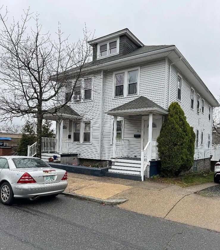
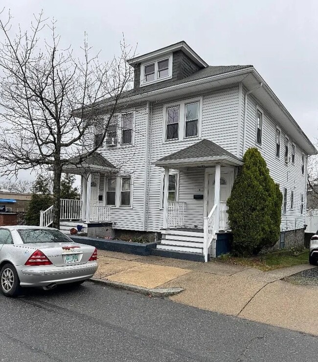
9 Meshaka St
Boston, MA 02132
1 Day Ago
Favorites
754-228-5994
-
Bedrooms
3
-
Bathrooms
1
-
Square Feet
1,500 sq ft
-
Available
Available Jul 1
Highlights
- Balcony
- Hardwood Floors
- Smoke Free
- Attic
9 Meshaka St

Favorites
About This Home
12 Month Lease,
$3,400 deposit,
Available Jul 1
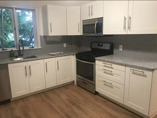
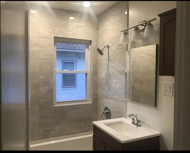
Recently renovated and spacious 3+ bedroom unit with modern kitchen and bathroom, high ceilings, and a private balcony. In-unit washer/dryer. Convenient access to major roads, highways, shops and the T. Close to Dedham Mall and Legacy Place. Water and sewer included. Average heating cost: $137/month. Average electricity cost: $123/month. Ample free parking. Lease term: 12+ months.
9 Meshaka St is an apartment community located in Suffolk County and the 02132 ZIP Code. This area is served by the Boston Public Schools attendance zone.
* Price shown is base rent and may not include non-optional fees and utilities.
Price, availability, fees, and any applicable rent special are subject to change without notice.
* Square footage definitions vary. Displayed square footage is approximate.
Apartment Features
Washer/Dryer
Dishwasher
Hardwood Floors
Microwave
- Washer/Dryer
- Heating
- Ceiling Fans
- Smoke Free
- Storage Space
- Dishwasher
- Disposal
- Stainless Steel Appliances
- Pantry
- Kitchen
- Microwave
- Oven
- Refrigerator
- Quartz Countertops
- Hardwood Floors
- Dining Room
- Family Room
- Office
- Attic
- Storage Space
- Balcony
Fees and Policies
The fees below are based on community-supplied data and may exclude additional fees and utilities.
- Cats Allowed
-
Fees not specified
-
Weight limit--
-
Pet Limit--
- Parking
-
Street--
Details
Utilities Included
-
Water
-
Trash Removal
-
Sewer
Property Information
-
2 units
Contact
- Phone Number
- Contact
Location
Get Directions
Upper Washington-Spring Street is a neighborhood southwest of Boston in West Roxbury. Residents will find that Upper Washington-Spring Street is home to many cozy residential areas and great amenities. The neighborhood’s northern border sits along the Charles River and surrounding parks like Millennium Park, giving residents easy access to outdoor recreation. The hospital that serves this area, West Roxbury VAMC, sits along the river as well. Within Upper Washington-Spring Street, residents will find that picturesque parks like Ohrenberger Woodland Park dot the area. To the east of town, residents can travel along VFW Parkway to get to eateries and retail stores.
This neighborhood is a great town for commuters as the MBTA has both bus stops and rail lines accessible to the area. Apartments and condos scattered throughout town make up the majority of Upper Washington-Spring Street’s diverse rental options.
Learn more about living in Upper Washington-Spring St
Education
| Colleges & Universities | Distance | ||
|---|---|---|---|
| Colleges & Universities | Distance | ||
| Drive: | 11 min | 4.0 mi | |
| Drive: | 17 min | 7.7 mi | |
| Drive: | 17 min | 7.9 mi | |
| Drive: | 16 min | 9.0 mi |
9 Meshaka St is within 11 minutes or 4.0 miles from Curry College. It is also near Boston College and Boston College, Brighton.
Schools


Public Elementary School
Grades PK-1
187 Students
Attendance Zone
Public Elementary & Middle School
Grades 3-8
451 Students
Attendance Zone
Public Elementary School
Grades PK-2
263 Students
Nearby
Public Middle School
Grades 6-8
133 Students
Attendance Zone
Public Middle & High School
Grades 6-12
871 Students
Attendance Zone
Public High School
Grades 12
39 Students
Attendance Zone
Public High School
Grades 12
408 Students
Attendance Zone
Private Elementary School
Grades PK-6
330 Students
Nearby
Private Middle & High School
Grades 7-12
304 Students
Nearby
School data provided by
 The GreatSchools Rating helps parents compare schools within a state based on a variety of school quality indicators and provides a helpful picture of how effectively each school serves all of its students. Ratings are on a scale of 1 (below average) to 10 (above average) and can include test scores, college readiness, academic progress, advanced courses, equity, discipline and attendance data. We also advise parents to visit schools, consider other information on school performance and programs, and consider family needs as part of the school selection process.
View GreatSchools Rating Methodology
Data provided by GreatSchools.org © 2025. All rights reserved.
View GreatSchools Rating Methodology
Data provided by GreatSchools.org © 2025. All rights reserved.
Transportation options available in Boston include Forest Hills, located 3.8 miles from 9 Meshaka St. 9 Meshaka St is near General Edward Lawrence Logan International, located 12.1 miles or 26 minutes away.
| Transit / Subway | Distance | ||
|---|---|---|---|
| Transit / Subway | Distance | ||
| Drive: | 9 min | 3.8 mi | |
| Drive: | 11 min | 4.7 mi | |
| Drive: | 11 min | 5.1 mi | |
| Drive: | 13 min | 5.7 mi | |
| Drive: | 13 min | 5.8 mi |
| Commuter Rail | Distance | ||
|---|---|---|---|
| Commuter Rail | Distance | ||
| Drive: | 6 min | 2.0 mi | |
| Drive: | 6 min | 2.3 mi | |
| Drive: | 6 min | 2.4 mi | |
| Drive: | 5 min | 2.5 mi | |
| Drive: | 8 min | 3.7 mi |
| Airports | Distance | ||
|---|---|---|---|
| Airports | Distance | ||
|
General Edward Lawrence Logan International
|
Drive: | 26 min | 12.1 mi |
Time and distance from 9 Meshaka St.
| Shopping Centers | Distance | ||
|---|---|---|---|
| Shopping Centers | Distance | ||
| Walk: | 3 min | 0.2 mi | |
| Walk: | 13 min | 0.7 mi | |
| Drive: | 4 min | 1.2 mi |
9 Meshaka St has 3 shopping centers within 1.2 miles, which is about a 4-minute walk. The miles and minutes will be for the farthest away property.
| Parks and Recreation | Distance | ||
|---|---|---|---|
| Parks and Recreation | Distance | ||
|
Brook Farm Historic Site
|
Drive: | 5 min | 2.1 mi |
|
Stony Brook Reservation
|
Drive: | 5 min | 2.2 mi |
|
Arnold Arboretum of Harvard University
|
Drive: | 8 min | 3.5 mi |
|
Mass Audubon's Boston Nature Center and Wildlife Sanctuary
|
Drive: | 12 min | 4.5 mi |
|
Mass Audubon's Blue Hills Trailside Museum
|
Drive: | 10 min | 4.5 mi |
9 Meshaka St has 5 parks within 4.5 miles, including Stony Brook Reservation, Brook Farm Historic Site, and Arnold Arboretum of Harvard University.
| Hospitals | Distance | ||
|---|---|---|---|
| Hospitals | Distance | ||
| Drive: | 8 min | 3.6 mi | |
| Drive: | 9 min | 3.8 mi | |
| Drive: | 10 min | 5.1 mi |
9 Meshaka St has 3 hospitals within 5.1 miles, the nearest is Bournewood Hospital which is 3.6 miles away and a 8 minute drive.
| Military Bases | Distance | ||
|---|---|---|---|
| Military Bases | Distance | ||
| Drive: | 23 min | 12.2 mi |
9 Meshaka St is 12.2 miles and a 23 minute drive from US Military Reservation.
Amenities
- Washer/Dryer
- Heating
- Ceiling Fans
- Smoke Free
- Storage Space
- Dishwasher
- Disposal
- Stainless Steel Appliances
- Pantry
- Kitchen
- Microwave
- Oven
- Refrigerator
- Quartz Countertops
- Hardwood Floors
- Dining Room
- Family Room
- Office
- Attic
- Storage Space
- Balcony
9 Meshaka St Photos
What Are Walk Score®, Transit Score®, and Bike Score® Ratings?
Walk Score® measures the walkability of any address. Transit Score® measures access to public transit. Bike Score® measures the bikeability of any address.
What is a Sound Score Rating?
A Sound Score Rating aggregates noise caused by vehicle traffic, airplane traffic and local sources

9 Meshaka St
Boston, MA 02132