

$2,200
/ Month
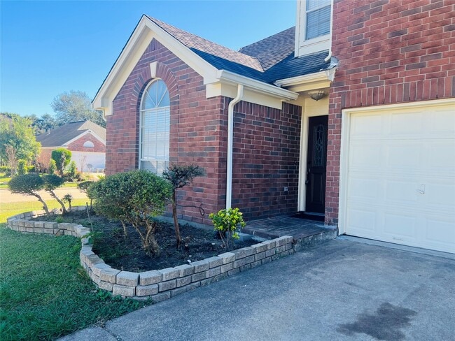
8903 N Deer Meadow Dr
Houston, TX 77071
Today
|
Edit
Favorites
281-933-6999
-
Bedrooms
4
-
Bathrooms
3
-
Square Feet
2,160 sq ft
-
Available
Available Now
Highlights
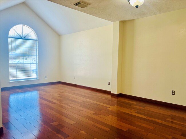
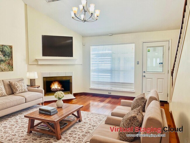
- Wood Flooring
- 1 Fireplace
- Corner Lot
- High Ceiling
- 2 Car Attached Garage
- Security System Owned
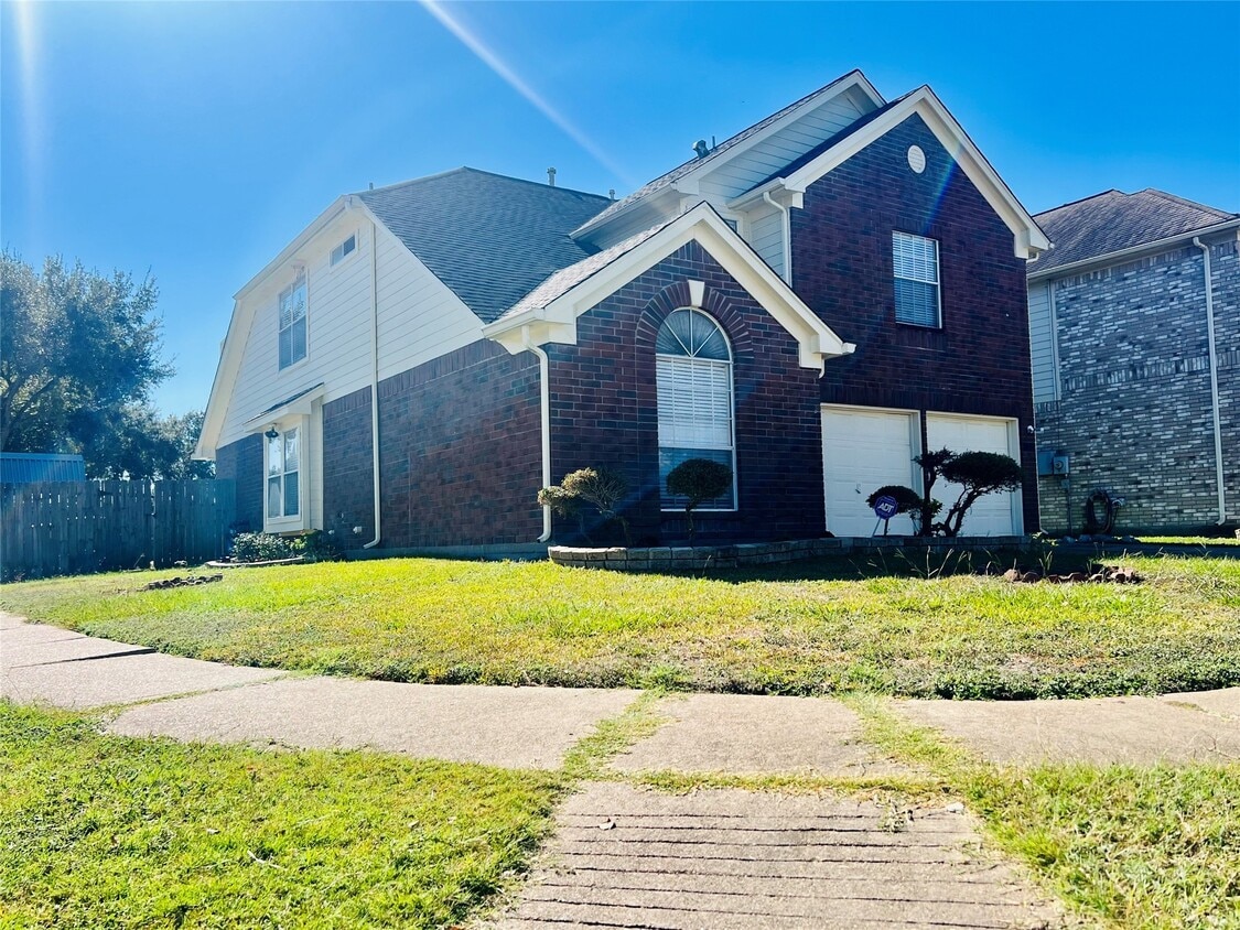
8903 N Deer Meadow Dr

Favorites
About This Home
Available Now
This beautiful 2-story home is in a CORNER lot next to the PARK. Open floor plan with high ceilings. Granite Countertop/Stainless steel appliance. Easy access to Bltwy 8 & 59. Some rooms are virtually staged MLS# 62202988
8903 N Deer Meadow Dr is a house located in Harris County and the 77071 ZIP Code. This area is served by the Houston Independent attendance zone.
* Price shown is base rent. Excludes user-selected optional fees and variable or usage-based fees and required charges due at or prior to move-in or at move-out. Price, availability, fees, and any applicable rent special are subject to change without notice.
* Square footage definitions vary. Displayed square footage is approximate.
Home Details
Home Type
Single Family Detached Home
Year Built
Built in 1995
Bedrooms and Bathrooms
2.5 Bathrooms
4 Bedrooms
Home Security
Security System Owned
Interior Spaces
Wood Flooring
1 Fireplace
High Ceiling
2,160 Sq Ft Home
2-Story Property
Kitchen
Gas Oven
Gas Range
Free-Standing Range
Laundry
Washer and Electric Dryer Hookup
Listing and Financial Details
Property Available on 11/12/25
Long Term Lease
Lot Details
4,590 Sq Ft Lot
Corner Lot
Parking
2 Car Attached Garage
Schools
Gross Elementary School
Welch Middle School
Westbury High School
Utilities
Central Heating and Cooling System
Heating System Uses Gas
Community Details
Overview
High Sierra Mgmt Association
West Fondren Place Sec 02 Subdivision
Pet Policy
Call for details about the types of pets allowed
Pet Deposit Required
Contact
- Listed by Jane NgaDung Nguyen | Alpha,REALTORS
- Phone Number
- Contact
-
Source
 Houston Association of REALTORS®
Copyright © 2025 Houston Association of Realtors. All rights reserved. All information provided by the listing agent/broker is deemed reliable but is not guaranteed and should be independently verified.
Location
Get Directions
Greater Fondren Southwest is part of the Brays Oaks District of Houston, Texas. This large neighborhood stretches from Brays Bayou Park to the north and US Route 90 to the south. The Sam Houston Tollway forms the western border of the neighborhood.
Named for oilman Walter Fondren, this historic neighborhood contains some hidden gems and is rapidly gaining in popularity due in part to its proximity to Downtown Houston, which is just 15 miles northeast. Houston Baptist University is just outside the neighborhood and is easily reached by heading north on Fondren Road. Greater Fondren Southwest is considered one of Houston's Super Neighborhoods. There’s an amazing mix of low-lying apartments and single-family homes for rent, meaning every renter will find their perfect fit.
Learn more about living in Greater Fondren Southwest
Education
| Colleges & Universities | Distance | ||
|---|---|---|---|
| Colleges & Universities | Distance | ||
| Drive: | 11 min | 4.6 mi | |
| Drive: | 11 min | 6.1 mi | |
| Drive: | 18 min | 11.3 mi | |
| Drive: | 16 min | 11.4 mi |
8903 N Deer Meadow Dr is within 11 minutes or 4.6 miles from Houston Baptist University. It is also near Houston Christian University and The Art Institute of Houston.
Schools


Public Elementary School
Grades PK-5
481 Students
Attendance Zone
Public Middle School
Grades 6-8
645 Students
Attendance Zone
Public High School
Grades 9-12
2,243 Students
Attendance Zone
Private Elementary School
Grades PK-3
Nearby
Private Elementary & Middle School
Grades PK-8
121 Students
Nearby
Private Elementary, Middle & High School
Grades K-12
Nearby
School data provided by
 The GreatSchools Rating helps parents compare schools within a state based on a variety of school quality indicators and provides a helpful picture of how effectively each school serves all of its students. Ratings are on a scale of 1 (below average) to 10 (above average) and can include test scores, college readiness, academic progress, advanced courses, equity, discipline and attendance data. We also advise parents to visit schools, consider other information on school performance and programs, and consider family needs as part of the school selection process.
View GreatSchools Rating Methodology
Data provided by GreatSchools.org © 2026. All rights reserved.
View GreatSchools Rating Methodology
Data provided by GreatSchools.org © 2026. All rights reserved.
Transportation options available in Houston include Fannin South, located 10.2 miles from 8903 N Deer Meadow Dr. 8903 N Deer Meadow Dr is near William P Hobby, located 20.3 miles or 32 minutes away, and George Bush Intcntl/Houston, located 37.7 miles or 45 minutes away.
| Transit / Subway | Distance | ||
|---|---|---|---|
| Transit / Subway | Distance | ||
|
|
Drive: | 16 min | 10.2 mi |
|
|
Drive: | 17 min | 10.8 mi |
|
|
Drive: | 16 min | 10.9 mi |
| Drive: | 18 min | 11.6 mi | |
|
|
Drive: | 19 min | 11.9 mi |
| Commuter Rail | Distance | ||
|---|---|---|---|
| Commuter Rail | Distance | ||
|
|
Drive: | 26 min | 17.3 mi |
| Airports | Distance | ||
|---|---|---|---|
| Airports | Distance | ||
|
William P Hobby
|
Drive: | 32 min | 20.3 mi |
|
George Bush Intcntl/Houston
|
Drive: | 45 min | 37.7 mi |
Time and distance from 8903 N Deer Meadow Dr.
| Shopping Centers | Distance | ||
|---|---|---|---|
| Shopping Centers | Distance | ||
| Walk: | 10 min | 0.5 mi | |
| Walk: | 10 min | 0.5 mi | |
| Drive: | 3 min | 1.1 mi |
8903 N Deer Meadow Dr has 3 shopping centers within 1.1 miles, which is about a 3-minute drive. The miles and minutes will be for the farthest away property.
| Parks and Recreation | Distance | ||
|---|---|---|---|
| Parks and Recreation | Distance | ||
|
Club Creek Park and Vietnam Veterans Memorial
|
Drive: | 8 min | 4.6 mi |
|
Arthur Storey Park
|
Drive: | 9 min | 5.6 mi |
|
Nature Discovery Center
|
Drive: | 15 min | 8.0 mi |
|
Buffalo Bayou Paddling Trail
|
Drive: | 16 min | 9.7 mi |
|
Houston Maritime Museum
|
Drive: | 18 min | 11.5 mi |
8903 N Deer Meadow Dr has 5 parks within 11.5 miles, including Club Creek Park and Vietnam Veterans Memorial, Arthur Storey Park, and Nature Discovery Center.
| Hospitals | Distance | ||
|---|---|---|---|
| Hospitals | Distance | ||
| Drive: | 15 min | 6.7 mi | |
| Drive: | 11 min | 7.2 mi | |
| Drive: | 12 min | 7.9 mi |
8903 N Deer Meadow Dr has 3 hospitals within 7.9 miles, the nearest is Behavioral Hospital of Bellaire which is 6.7 miles away and a 15 minute drive.
| Military Bases | Distance | ||
|---|---|---|---|
| Military Bases | Distance | ||
| Drive: | 44 min | 32.5 mi | |
| Drive: | 73 min | 58.0 mi |
8903 N Deer Meadow Dr is 32.5 miles from Lyndon B Johnson Space Center, and is convenient to other military bases, including Pelican Spit Military Reservation.
You May Also Like
Similar Rentals Nearby
-
-

-

-
-
-
-
-
1 / 36

-
1 / 48

-


What Are Walk Score®, Transit Score®, and Bike Score® Ratings?
Walk Score® measures the walkability of any address. Transit Score® measures access to public transit. Bike Score® measures the bikeability of any address.
What is a Sound Score Rating?
A Sound Score Rating aggregates noise caused by vehicle traffic, airplane traffic and local sources
8903 N Deer Meadow Dr
Houston, TX 77071