
-
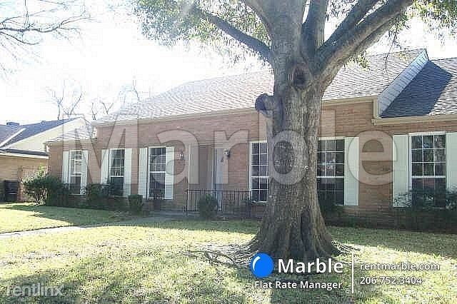
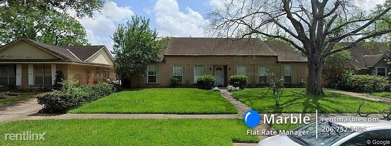
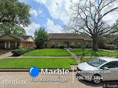
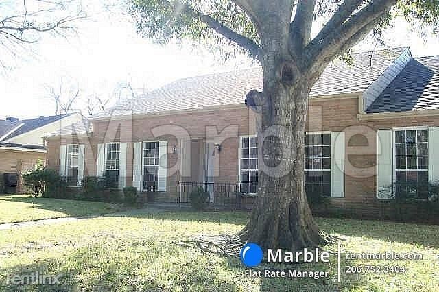
4 br, 2 bath House - 5411 Ariel St
-

-
-
$2,600
/ Month
5411 Ariel St
Houston, TX 77096
2 Weeks Ago
|
Edit
Favorites
5411 Ariel St

Favorites
Check Back Soon for Upcoming Availability
| Beds | Baths | Average SF |
|---|---|---|
| 4 Bedrooms 4 Bedrooms 4 Br | 2 Baths 2 Baths 2 Ba | — |
Fees and Policies
The fees below are based on community-supplied data and may exclude additional fees and utilities.
- Dogs Allowed
-
Fees not specified
- Cats Allowed
-
Fees not specified
About This Property
- 5411 Ariel St is located in the Kingston Terrace subdivision in Harris County. Good School District, close to major highways and downtown. (RLNE7971936) Other Amenities: Parking. Appliances: Air Conditioning, Refrigerator, Oven, Microwave, Washer & Dryer On-Site. Lease lengths: 12 Months. Utilities: Resident Pays Electricity, Resident Pays Gas, Resident Pays Water. Pet policies: Small Dogs Allowed, Cats Allowed, Large Dogs Allowed.
5411 Ariel St is a house located in Harris County and the 77096 ZIP Code. This area is served by the Houston Independent attendance zone.
Unique Features
- Oven
House Features
- Air Conditioning
- Laundry Facilities
Location
Get Directions
Founded in 1955, Meyerland Area is a 6,000-acre community southwest of Houston and encompassed by beautiful homes near the Interstate 610 Loop and Beltway 8. In addition to many houses of worship, Meyerland Area is also home to the Meyerland Plaza shopping center on Beechnut Street.
Residents of this community are served by the Houston Independent School District. After the school day, kids enjoy playtime on the jungle gyms at Meyerland Park and Herbert Godwin Park. Numerous restaurants surround the plaza, and the Brays Bayou Greenway provides locals a scenic jog along the bayou.
Learn more about living in Meyerland AreaBelow are rent ranges for similar nearby apartments
Amenities
- Air Conditioning
- Laundry Facilities
- Oven
Education
| Colleges & Universities | Distance | ||
|---|---|---|---|
| Colleges & Universities | Distance | ||
| Drive: | 8 min | 3.0 mi | |
| Drive: | 9 min | 3.2 mi | |
| Drive: | 11 min | 5.7 mi | |
| Drive: | 12 min | 6.1 mi |
5411 Ariel St is within 8 minutes or 3.0 miles from Houston Christian University. It is also near Houston Baptist University and The Art Institute of Houston.
Schools


Public Elementary School
Grades PK-5
769 Students
Attendance Zone
Public Middle School
Grades 6-8
840 Students
Attendance Zone
Public High School
Grades 9-12
3,170 Students
Attendance Zone
Private Elementary, Middle & High School
Grades K-12
565 Students
Nearby
Private Elementary & Middle School
Grades PK-8
155 Students
Nearby
School data provided by
 The GreatSchools Rating helps parents compare schools within a state based on a variety of school quality indicators and provides a helpful picture of how effectively each school serves all of its students. Ratings are on a scale of 1 (below average) to 10 (above average) and can include test scores, college readiness, academic progress, advanced courses, equity, discipline and attendance data. We also advise parents to visit schools, consider other information on school performance and programs, and consider family needs as part of the school selection process.
View GreatSchools Rating Methodology
Data provided by GreatSchools.org © 2025. All rights reserved.
View GreatSchools Rating Methodology
Data provided by GreatSchools.org © 2025. All rights reserved.
Transportation options available in Houston include Fannin South, located 5.5 miles from 5411 Ariel St. 5411 Ariel St is near William P Hobby, located 16.6 miles or 31 minutes away, and George Bush Intcntl/Houston, located 31.0 miles or 41 minutes away.
| Transit / Subway | Distance | ||
|---|---|---|---|
| Transit / Subway | Distance | ||
|
|
Drive: | 10 min | 5.5 mi |
|
|
Drive: | 10 min | 5.5 mi |
|
|
Drive: | 11 min | 5.6 mi |
| Drive: | 13 min | 6.3 mi | |
|
|
Drive: | 13 min | 6.6 mi |
| Commuter Rail | Distance | ||
|---|---|---|---|
| Commuter Rail | Distance | ||
|
|
Drive: | 20 min | 11.6 mi |
| Airports | Distance | ||
|---|---|---|---|
| Airports | Distance | ||
|
William P Hobby
|
Drive: | 31 min | 16.6 mi |
|
George Bush Intcntl/Houston
|
Drive: | 41 min | 31.0 mi |
Time and distance from 5411 Ariel St.
| Shopping Centers | Distance | ||
|---|---|---|---|
| Shopping Centers | Distance | ||
| Walk: | 7 min | 0.4 mi | |
| Walk: | 8 min | 0.4 mi | |
| Walk: | 13 min | 0.7 mi |
5411 Ariel St has 3 shopping centers within 0.7 mile, which is about a 13-minute walk. The miles and minutes will be for the farthest away property.
| Parks and Recreation | Distance | ||
|---|---|---|---|
| Parks and Recreation | Distance | ||
|
Nature Discovery Center
|
Drive: | 6 min | 3.0 mi |
|
Club Creek Park and Vietnam Veterans Memorial
|
Drive: | 12 min | 5.4 mi |
|
Houston Maritime Museum
|
Drive: | 12 min | 5.5 mi |
|
Buffalo Bayou Paddling Trail
|
Drive: | 13 min | 5.8 mi |
|
Lowrey Arboretum
|
Drive: | 16 min | 6.8 mi |
5411 Ariel St has 5 parks within 6.8 miles, including Nature Discovery Center, Club Creek Park and Vietnam Veterans Memorial, and Houston Maritime Museum.
| Hospitals | Distance | ||
|---|---|---|---|
| Hospitals | Distance | ||
| Drive: | 5 min | 2.1 mi | |
| Drive: | 7 min | 3.0 mi | |
| Drive: | 11 min | 5.5 mi |
5411 Ariel St has 3 hospitals within 5.5 miles, the nearest is Behavioral Hospital of Bellaire which is 2.1 miles away and a 5 minute drive.
| Military Bases | Distance | ||
|---|---|---|---|
| Military Bases | Distance | ||
| Drive: | 45 min | 31.0 mi | |
| Drive: | 73 min | 56.6 mi |
5411 Ariel St is 31.0 miles from Lyndon B Johnson Space Center, and is convenient to other military bases, including Pelican Spit Military Reservation.
You May Also Like
Similar Rentals Nearby
-
-

-

-

-
-
-
-
1 / 39

-
1 / 48

-


What Are Walk Score®, Transit Score®, and Bike Score® Ratings?
Walk Score® measures the walkability of any address. Transit Score® measures access to public transit. Bike Score® measures the bikeability of any address.
What is a Sound Score Rating?
A Sound Score Rating aggregates noise caused by vehicle traffic, airplane traffic and local sources
5411 Ariel St
Houston, TX 77096