$1,500
/ Month
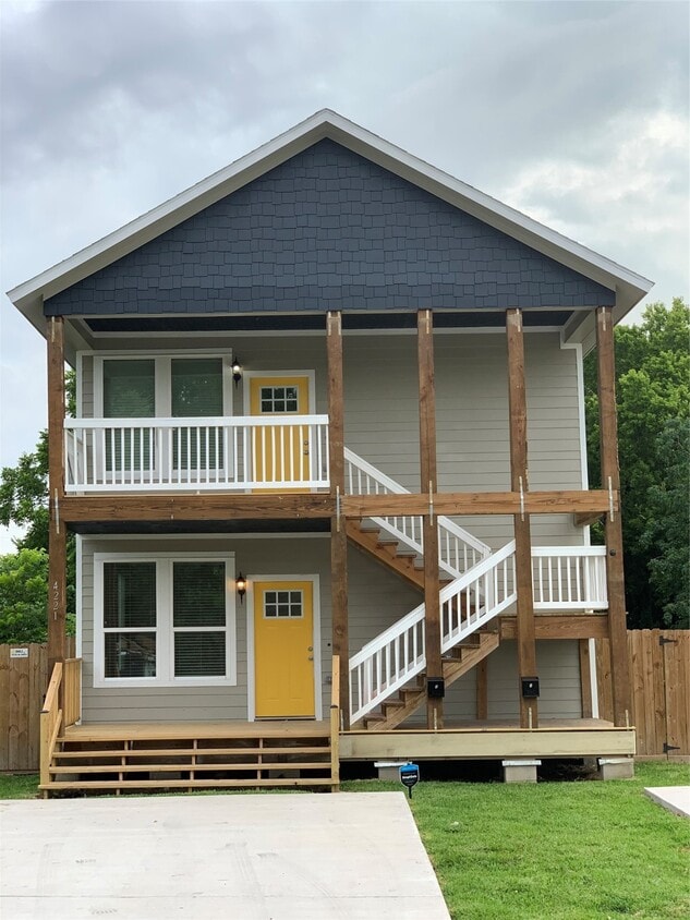
4221 Alvin St
Houston, TX 77051
Today
Favorites
713-409-5209
-
Bedrooms
3
-
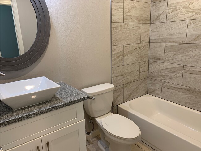
Bathrooms
2
-
Square Feet
1,325 sq ft
-
Available
Available Now
Highlights
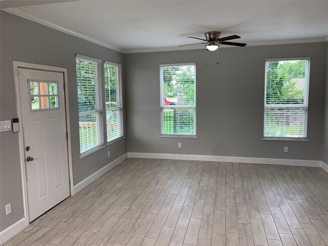
- Colonial Architecture
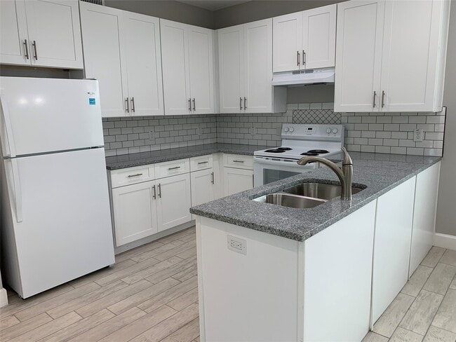
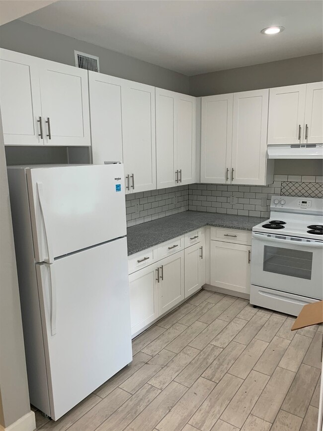
- Granite Countertops
- Home Office
- Crown Molding
- Tile Flooring
- Central Heating and Cooling System
4221 Alvin St

Favorites
About This Home
Available Now
Three Bedroom 2 Bath Beautiful Unit FOR LEASE! Tile Floors! Granite Counter Tops! Large Closets! Beautiful Kitchen! Washer & Dryer Included! Section 8 Considered. Will Not Last Long! Unit B is Downstairs Unit MLS# 11008372
4221 Alvin St is a townhome located in Harris County and the 77051 ZIP Code. This area is served by the Houston Independent attendance zone.
* Price shown is base rent. Excludes user-selected optional fees and variable or usage-based fees and required charges due at or prior to move-in or at move-out. Price, availability, fees, and any applicable rent special are subject to change without notice.
* Square footage definitions vary. Displayed square footage is approximate.
Home Details
Home Type
Duplex
Year Built
Built in 2019
Bedrooms and Bathrooms
2 Full Bathrooms
3 Bedrooms
Home Design
Colonial Architecture
Interior Spaces
Home Office
Crown Molding
Tile Flooring
Combination Kitchen and Dining Room
Utility Room
1,325 Sq Ft Home
1-Story Property
Kitchen
Granite Countertops
Electric Range
Electric Oven
Microwave
Dishwasher
Disposal
Laundry
Dryer
Washer
Listing and Financial Details
Property Available on 9/8/25
Long Term Lease
Lot Details
5,775 Sq Ft Lot
South Facing Home
Parking
Assigned Parking
Schools
Bastian Elementary School
Attucks Middle School
Worthing High School
Utilities
Central Heating and Cooling System
Cable TV Available
Community Details
Overview
2 Units
Sunnyside Courts Subdivision
Pet Policy
No Pets Allowed
Contact
- Listed by Eric Odom | Kevin Riles Commercial
- Phone Number
- Contact
-
Source
 Houston Association of REALTORS®
Copyright © 2025 Houston Association of Realtors. All rights reserved. All information provided by the listing agent/broker is deemed reliable but is not guaranteed and should be independently verified.
Location
Get Directions
Nestled just eight miles south of Downtown Houston, residents of Sunnyside find its close proximity to city attractions and low cost of living attractive. The community borders the 610 Loop and is inside the Beltway 8, making it simple for locals to commute to work.
There’s definitely a suburban vibe to the area. Students of Sunnyside are zoned to the Houston Independent School District. Residents look forward to the amenities at Sunnyside Park, including the playground, sports courts, walking/biking trails, and the gym that’s located in the community center.
Cullen Boulevard and Reed Road house many local restaurants and quick-bite establishments. It’s only a short ride to Houston attractions like the zoo, aquarium, and the Children’s Museum of Houston. Need to get to William P. Hobby Airport? You’re only a 15-minute drive away.
Learn more about living in Sunnyside
Education
| Colleges & Universities | Distance | ||
|---|---|---|---|
| Colleges & Universities | Distance | ||
| Drive: | 10 min | 4.8 mi | |
| Drive: | 10 min | 5.2 mi | |
| Drive: | 11 min | 5.2 mi | |
| Drive: | 11 min | 5.5 mi |
4221 Alvin St is within 10 minutes or 4.8 miles from Texas Southern University. It is also near UT Health Houston and University of Houston.
Schools


Public Elementary School
Grades PK-5
648 Students
Attendance Zone
Public Middle School
Grades 6-8
439 Students
Attendance Zone
Public High School
Grades 9-12
827 Students
Attendance Zone
Private Elementary, Middle & High School
Grades PK-11
Nearby
Private High School
Grades 9-12
211 Students
Nearby
School data provided by
 The GreatSchools Rating helps parents compare schools within a state based on a variety of school quality indicators and provides a helpful picture of how effectively each school serves all of its students. Ratings are on a scale of 1 (below average) to 10 (above average) and can include test scores, college readiness, academic progress, advanced courses, equity, discipline and attendance data. We also advise parents to visit schools, consider other information on school performance and programs, and consider family needs as part of the school selection process.
View GreatSchools Rating Methodology
Data provided by GreatSchools.org © 2025. All rights reserved.
View GreatSchools Rating Methodology
Data provided by GreatSchools.org © 2025. All rights reserved.
Transportation options available in Houston include Fannin South, located 2.9 miles from 4221 Alvin St. 4221 Alvin St is near William P Hobby, located 9.2 miles or 20 minutes away, and George Bush Intcntl/Houston, located 26.2 miles or 36 minutes away.
| Transit / Subway | Distance | ||
|---|---|---|---|
| Transit / Subway | Distance | ||
|
|
Drive: | 5 min | 2.9 mi |
|
|
Drive: | 7 min | 3.7 mi |
| Drive: | 7 min | 4.1 mi | |
|
|
Drive: | 8 min | 4.5 mi |
| Drive: | 9 min | 4.8 mi |
| Commuter Rail | Distance | ||
|---|---|---|---|
| Commuter Rail | Distance | ||
|
|
Drive: | 16 min | 9.0 mi |
| Airports | Distance | ||
|---|---|---|---|
| Airports | Distance | ||
|
William P Hobby
|
Drive: | 20 min | 9.2 mi |
|
George Bush Intcntl/Houston
|
Drive: | 36 min | 26.2 mi |
Time and distance from 4221 Alvin St.
| Shopping Centers | Distance | ||
|---|---|---|---|
| Shopping Centers | Distance | ||
| Walk: | 15 min | 0.8 mi | |
| Walk: | 16 min | 0.8 mi | |
| Walk: | 18 min | 0.9 mi |
4221 Alvin St has 3 shopping centers within 0.9 mile, which is about a 18-minute walk. The miles and minutes will be for the farthest away property.
| Parks and Recreation | Distance | ||
|---|---|---|---|
| Parks and Recreation | Distance | ||
|
Houston Zoo
|
Drive: | 10 min | 5.0 mi |
|
Children's Museum of Houston
|
Drive: | 9 min | 5.3 mi |
|
Hermann Park
|
Drive: | 11 min | 5.3 mi |
|
Houston Maritime Museum
|
Drive: | 10 min | 5.5 mi |
|
Cockrell Butterfly Center
|
Drive: | 11 min | 5.8 mi |
4221 Alvin St has 5 parks within 5.8 miles, including Houston Zoo, Hermann Park, and Houston Maritime Museum.
| Hospitals | Distance | ||
|---|---|---|---|
| Hospitals | Distance | ||
| Drive: | 6 min | 3.0 mi | |
| Drive: | 8 min | 4.2 mi | |
| Drive: | 8 min | 4.5 mi |
4221 Alvin St has 3 hospitals within 4.5 miles, the nearest is Harris Health System which is 3.0 miles away and a 6 minute drive.
| Military Bases | Distance | ||
|---|---|---|---|
| Military Bases | Distance | ||
| Drive: | 36 min | 25.1 mi | |
| Drive: | 65 min | 50.6 mi |
4221 Alvin St is 25.1 miles from Lyndon B Johnson Space Center, and is convenient to other military bases, including Pelican Spit Military Reservation.
You May Also Like
Similar Rentals Nearby


What Are Walk Score®, Transit Score®, and Bike Score® Ratings?
Walk Score® measures the walkability of any address. Transit Score® measures access to public transit. Bike Score® measures the bikeability of any address.
What is a Sound Score Rating?
A Sound Score Rating aggregates noise caused by vehicle traffic, airplane traffic and local sources

4221 Alvin St
Houston, TX 77051