-
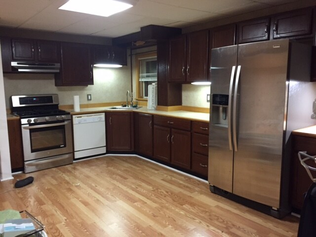
Large eat in kitchen
389 West St
389 West St,
Braintree,
MA
02184
2 Weeks Ago
Favorites
389 West St

Favorites
Check Back Soon for Upcoming Availability
Fees and Policies
The fees below are based on community-supplied data and may exclude additional fees and utilities.
- Parking
-
Surface Lot--
Details
Lease Options
-
12 Months
About 389 West St Braintree, MA 02184
2 Bedroom. 1 Bath large eat in kitchen. Owner occupied 2 family. Minutes to Plaza and rt.3, 95,and 93. 11miles 20minutes to Boston. Close to T and minutes from bus stop. Large yard . Parking. Elementary and Middle school bus stops at the end of drive. Young professional family neighborhood. All utilities heat, hot water, electric included.
389 West St is an apartment community located in Norfolk County and the 02184 ZIP Code.
Apartment Features
- Laundry Facilities
Location
Get Directions
Situated about 12 miles south of Boston, Braintree offers the perfect balance of historic charm, modern business complexes, and a small-town atmosphere. North Braintree stands out as the more metropolitan side of the city with ample amenities, public transportation options, and access to major highways.
Residents choose apartments in North Braintree to enjoy a green community teeming with local parks and tree-lined city streets alongside a vibrant shopping scene. Have a day of shopping at the South Shore Plaza, one of the Northeast's largest shopping centers, or enjoy easy access to other major attractions like the Blue Hills Reservation and Downtown Boston.
Learn more about living in North BraintreeBelow are rent ranges for similar nearby apartments
Amenities
- Laundry Facilities
Education
| Colleges & Universities | Distance | ||
|---|---|---|---|
| Colleges & Universities | Distance | ||
| Drive: | 12 min | 5.2 mi | |
| Drive: | 15 min | 9.0 mi | |
| Drive: | 17 min | 9.0 mi | |
| Drive: | 19 min | 11.6 mi |
389 West St is within 12 minutes or 5.2 miles from Massasoit C.C., Canton Campus. It is also near Curry College and UMass Boston.
Transportation options available in Braintree include Braintree Station, located 1.9 miles from 389 West St. 389 West St is near General Edward Lawrence Logan International, located 14.3 miles or 23 minutes away.
| Transit / Subway | Distance | ||
|---|---|---|---|
| Transit / Subway | Distance | ||
|
|
Drive: | 5 min | 1.9 mi |
|
|
Drive: | 6 min | 2.7 mi |
|
|
Drive: | 10 min | 5.3 mi |
|
|
Drive: | 11 min | 6.0 mi |
|
|
Drive: | 11 min | 6.1 mi |
| Commuter Rail | Distance | ||
|---|---|---|---|
| Commuter Rail | Distance | ||
|
|
Drive: | 3 min | 1.6 mi |
| Drive: | 7 min | 3.5 mi | |
|
|
Drive: | 9 min | 4.1 mi |
|
|
Drive: | 9 min | 4.5 mi |
|
|
Drive: | 12 min | 6.3 mi |
| Airports | Distance | ||
|---|---|---|---|
| Airports | Distance | ||
|
General Edward Lawrence Logan International
|
Drive: | 23 min | 14.3 mi |
Time and distance from 389 West St.
| Shopping Centers | Distance | ||
|---|---|---|---|
| Shopping Centers | Distance | ||
| Walk: | 11 min | 0.6 mi | |
| Walk: | 17 min | 0.9 mi | |
| Walk: | 18 min | 0.9 mi |
389 West St has 3 shopping centers within 0.9 mile, which is about a 18-minute walk. The miles and minutes will be for the farthest away property.
| Parks and Recreation | Distance | ||
|---|---|---|---|
| Parks and Recreation | Distance | ||
|
Adams National Historical Park
|
Drive: | 9 min | 4.5 mi |
|
Blue Hills Reservation
|
Drive: | 10 min | 6.1 mi |
|
Houghton's Pond Recreation Area
|
Drive: | 10 min | 6.1 mi |
|
Mass Audubon's Blue Hills Trailside Museum
|
Drive: | 11 min | 7.1 mi |
|
Webb Memorial State Park
|
Drive: | 16 min | 7.8 mi |
389 West St has 5 parks within 7.8 miles, including Adams National Historical Park, Blue Hills Reservation, and Houghton's Pond Recreation Area.
| Hospitals | Distance | ||
|---|---|---|---|
| Hospitals | Distance | ||
| Drive: | 9 min | 4.8 mi | |
| Drive: | 11 min | 6.5 mi | |
| Drive: | 11 min | 6.8 mi |
389 West St has 3 hospitals within 6.8 miles, the nearest is South Shore Hospital which is 4.8 miles away and a 9 minute drive.
You May Also Like
Similar Rentals Nearby


What Are Walk Score®, Transit Score®, and Bike Score® Ratings?
Walk Score® measures the walkability of any address. Transit Score® measures access to public transit. Bike Score® measures the bikeability of any address.
What is a Sound Score Rating?
A Sound Score Rating aggregates noise caused by vehicle traffic, airplane traffic and local sources