$3,500 / Month
38 W Cedar St Unit 3
Boston, MA 02108
4 Days Ago
Favorites
857-365-6702
-
Bedrooms
2
-
Bathrooms
2
-
Square Feet
900 sq ft
-
Available
Available Jul 1
Highlight
- Smoke Free
38 W Cedar St Unit 3

Favorites
About This Home
12 Month Lease,
$3,500 deposit,
Available Jul 1
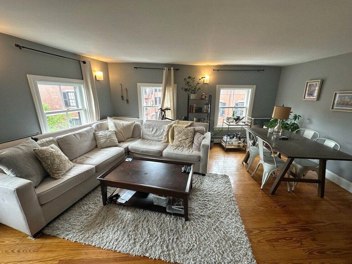
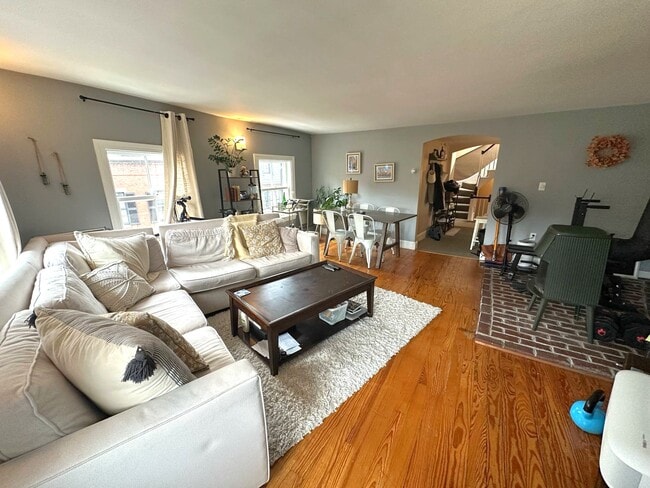
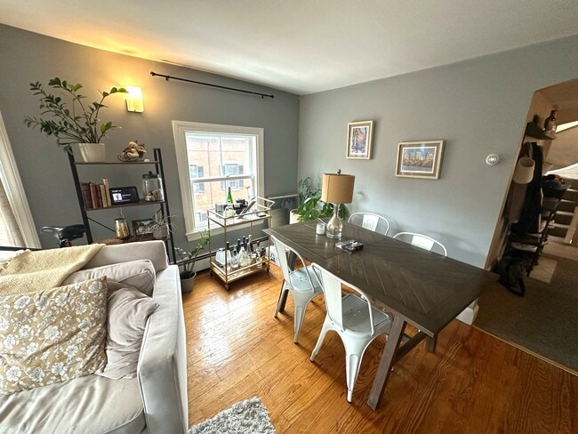
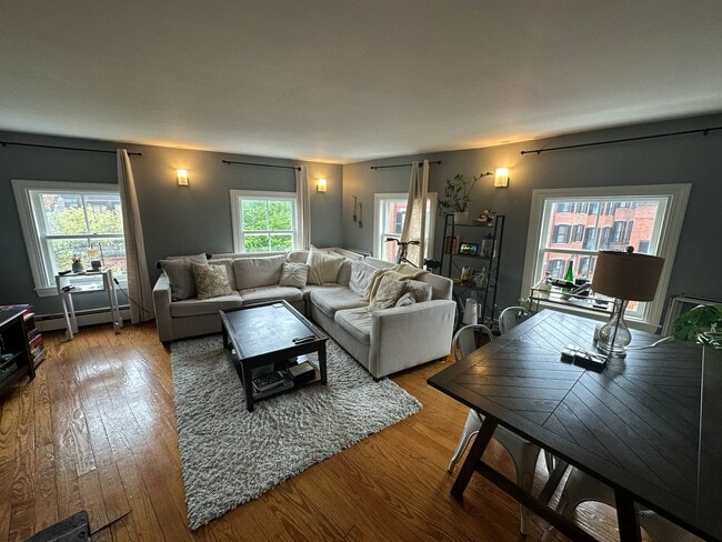
Available July 1st! Spacious two-floor unit overlooking the picturesque intersection of West Cedar and Pinckney. The first floor features the kitchen, full bath, one bedroom, and spacious living room with charming views. Top floor features additional bedroom and full bath, plus large walk in closet for storage. Professionally managed building with heat and hot water included. No undergrads, no pets.
38 W Cedar St is an apartment community located in Suffolk County and the 02108 ZIP Code.
* Price shown is base rent and may not include non-optional fees and utilities.
Price, availability, fees, and any applicable rent special are subject to change without notice.
* Square footage definitions vary. Displayed square footage is approximate.
Apartment Features
- Smoke Free
- Dishwasher
Fees and Policies
The fees below are based on community-supplied data and may exclude additional fees and utilities.
Details
Utilities Included
-
Water
-
Heat
Property Information
-
4 units
Contact
- Phone Number
- Contact
Location
Get Directions
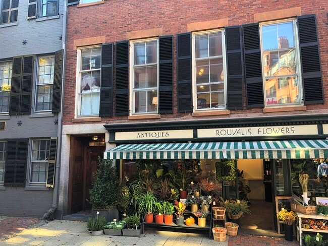
An upscale historic district in downtown Boston, Beacon Hill resides on the coast of the Charles River, just north of the 50-acre Boston Common.. This neighborhood is one of the oldest and most picturesque in the country with brick-lined streets, gas lanterns, and historic landmarks spotting the landscape. With its stately brick homes, cobblestone streets, and colonial roots, Beacon Hill is a charming historic region with plenty of amenities to offer prospective renters.
Historic architecture, antique shops, and fine dining spots define this Boston neighborhood. Visit historic homes like Nichols House Museum to tour a grand Beacon Hill residence from 1804, or venture over to the Museum of African American History on Joy Street. A prominent landmark and must-visit location is The Massachusetts State House in the center of town, built in 1795.
Beacon Hill’s location is ideal for office commuters and city lovers.
Learn more about living in Beacon Hill
Education
| Colleges & Universities | Distance | ||
|---|---|---|---|
| Colleges & Universities | Distance | ||
| Walk: | 11 min | 0.6 mi | |
| Walk: | 12 min | 0.6 mi | |
| Drive: | 4 min | 1.3 mi | |
| Drive: | 7 min | 3.0 mi |
38 W Cedar St Unit 3 is within 11 minutes or 0.6 mile from Emerson College. It is also near Suffolk University and Tufts University, Boston.
Transportation options available in Boston include Bowdoin Station, located 0.5 mile from 38 W Cedar St Unit 3. 38 W Cedar St Unit 3 is near General Edward Lawrence Logan International, located 4.0 miles or 10 minutes away.
| Transit / Subway | Distance | ||
|---|---|---|---|
| Transit / Subway | Distance | ||
|
|
Walk: | 10 min | 0.5 mi |
|
|
Walk: | 11 min | 0.6 mi |
|
|
Walk: | 11 min | 0.6 mi |
|
|
Walk: | 11 min | 0.6 mi |
|
|
Drive: | 5 min | 1.6 mi |
| Commuter Rail | Distance | ||
|---|---|---|---|
| Commuter Rail | Distance | ||
|
|
Drive: | 6 min | 1.2 mi |
|
|
Drive: | 4 min | 1.3 mi |
|
|
Drive: | 4 min | 1.3 mi |
|
|
Drive: | 7 min | 2.2 mi |
|
|
Drive: | 10 min | 5.1 mi |
| Airports | Distance | ||
|---|---|---|---|
| Airports | Distance | ||
|
General Edward Lawrence Logan International
|
Drive: | 10 min | 4.0 mi |
Time and distance from 38 W Cedar St Unit 3.
| Shopping Centers | Distance | ||
|---|---|---|---|
| Shopping Centers | Distance | ||
| Drive: | 4 min | 1.2 mi | |
| Drive: | 4 min | 1.2 mi | |
| Drive: | 4 min | 1.3 mi |
38 W Cedar St Unit 3 has 3 shopping centers within 1.3 miles, which is about a 4-minute drive. The miles and minutes will be for the farthest away property.
| Parks and Recreation | Distance | ||
|---|---|---|---|
| Parks and Recreation | Distance | ||
|
Boston Public Garden
|
Walk: | 7 min | 0.4 mi |
|
Boston African American National Historic Site
|
Walk: | 9 min | 0.5 mi |
|
Boston National Historical Park
|
Walk: | 15 min | 0.8 mi |
|
Museum of Science
|
Drive: | 5 min | 1.3 mi |
|
Boston Harbor Islands National Recreation Area
|
Drive: | 4 min | 1.3 mi |
38 W Cedar St Unit 3 has 5 parks within 1.3 miles, including Boston Public Garden, Boston African American National Historic Site, and Museum of Science.
| Hospitals | Distance | ||
|---|---|---|---|
| Hospitals | Distance | ||
| Walk: | 6 min | 0.3 mi | |
| Walk: | 6 min | 0.3 mi | |
| Walk: | 8 min | 0.5 mi |
38 W Cedar St Unit 3 has 3 hospitals within 0.5 mile, the nearest is Massachusetts General Hospital which is 0.3 mile away and a 6 minute walk.
| Military Bases | Distance | ||
|---|---|---|---|
| Military Bases | Distance | ||
| Drive: | 31 min | 16.1 mi |
38 W Cedar St Unit 3 is 16.1 miles and a 31 minute drive from Hanscom Air Force Base.
Amenities
- Smoke Free
- Dishwasher
38 W Cedar St Unit 3 Photos
What Are Walk Score®, Transit Score®, and Bike Score® Ratings?
Walk Score® measures the walkability of any address. Transit Score® measures access to public transit. Bike Score® measures the bikeability of any address.
What is a Sound Score Rating?
A Sound Score Rating aggregates noise caused by vehicle traffic, airplane traffic and local sources

38 W Cedar St
Boston, MA 02108