
$2,000 / Month
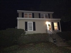
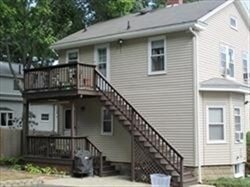
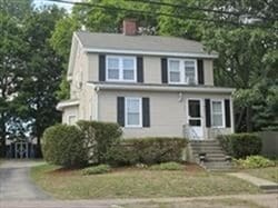
355 Hancock St Unit 1
Braintree, MA 02184
2 Weeks Ago
Favorites
355 Hancock St Unit 1

Favorites
Check Back Soon for Upcoming Availability
| Beds | Baths | Average SF |
|---|---|---|
| 1 Bedroom 1 Bedroom 1 Br | 1 Bath 1 Bath 1 Ba | 650 SF |
About This Property
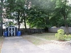
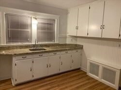
Convenient location for this 3 room 1 bedroom apt. in Braintree. Good sized living room and bedroom with hardwood floors. Private rear porch,nice yard and plenty of private parking. W/D hookup in the basement - extra storage too. Bus stop out font and close to Braintree "T" Station. Good credit and references a must!
355 Hancock St is an apartment community located in Norfolk County and the 02184 ZIP Code.
Location
Get Directions
Located nearly 14 miles south of Boston along Route 3, South Braintree sits serenely in the suburbs as a quiet, residential neighborhood filled mostly with Boston commuters. The neighborhood is a popular escape from the historic city to the north, with great schools and a welcoming atmosphere that make it extremely family friendly. South Braintree offers renters mostly upscale single-family homes with multiple bedrooms on calm, tree-lined streets.
Restaurants and shopping abound in and around the intersection of Ivory Street and Union Street. With all the charms of small-town life, South Braintree gives residents convenient proximity to nearby Boston while still providing the charm and comfort of a small town.
Learn more about living in South BraintreeBelow are rent ranges for similar nearby apartments
Education
| Colleges & Universities | Distance | ||
|---|---|---|---|
| Colleges & Universities | Distance | ||
| Drive: | 15 min | 7.0 mi | |
| Drive: | 18 min | 8.7 mi | |
| Drive: | 18 min | 10.6 mi | |
| Drive: | 20 min | 10.6 mi |
355 Hancock St Unit 1 is within 15 minutes or 7.0 miles from Massasoit C.C., Canton Campus. It is also near Massasoit C.C., Brockton and Curry College.
Transportation options available in Braintree include Braintree Station, located 1.7 miles from 355 Hancock St Unit 1. 355 Hancock St Unit 1 is near General Edward Lawrence Logan International, located 15.9 miles or 26 minutes away.
| Transit / Subway | Distance | ||
|---|---|---|---|
| Transit / Subway | Distance | ||
|
|
Drive: | 4 min | 1.7 mi |
|
|
Drive: | 7 min | 3.4 mi |
|
|
Drive: | 11 min | 5.6 mi |
|
|
Drive: | 14 min | 6.7 mi |
|
|
Drive: | 13 min | 7.7 mi |
| Commuter Rail | Distance | ||
|---|---|---|---|
| Commuter Rail | Distance | ||
|
|
Drive: | 3 min | 1.5 mi |
|
|
Drive: | 5 min | 3.1 mi |
| Drive: | 7 min | 3.5 mi | |
|
|
Drive: | 9 min | 4.6 mi |
|
|
Drive: | 9 min | 5.2 mi |
| Airports | Distance | ||
|---|---|---|---|
| Airports | Distance | ||
|
General Edward Lawrence Logan International
|
Drive: | 26 min | 15.9 mi |
Time and distance from 355 Hancock St Unit 1.
| Shopping Centers | Distance | ||
|---|---|---|---|
| Shopping Centers | Distance | ||
| Walk: | 21 min | 1.1 mi | |
| Drive: | 3 min | 1.5 mi | |
| Drive: | 5 min | 1.9 mi |
355 Hancock St Unit 1 has 3 shopping centers within 1.9 miles, which is about a 5-minute walk. The miles and minutes will be for the farthest away property.
| Parks and Recreation | Distance | ||
|---|---|---|---|
| Parks and Recreation | Distance | ||
|
Adams National Historical Park
|
Drive: | 10 min | 5.0 mi |
|
Ames Nowell State Park
|
Drive: | 10 min | 5.8 mi |
|
Houghton's Pond Recreation Area
|
Drive: | 13 min | 7.7 mi |
|
Blue Hills Reservation
|
Drive: | 13 min | 7.7 mi |
|
Mass Audubon's Blue Hills Trailside Museum
|
Drive: | 14 min | 8.7 mi |
355 Hancock St Unit 1 has 5 parks within 8.7 miles, including Adams National Historical Park, Ames Nowell State Park, and Houghton's Pond Recreation Area.
| Hospitals | Distance | ||
|---|---|---|---|
| Hospitals | Distance | ||
| Drive: | 6 min | 3.6 mi | |
| Drive: | 14 min | 8.2 mi | |
| Drive: | 14 min | 8.4 mi |
355 Hancock St Unit 1 has 3 hospitals within 8.4 miles, the nearest is South Shore Hospital which is 3.6 miles away and a 6 minute drive.
You May Also Like
Similar Rentals Nearby


What Are Walk Score®, Transit Score®, and Bike Score® Ratings?
Walk Score® measures the walkability of any address. Transit Score® measures access to public transit. Bike Score® measures the bikeability of any address.
What is a Sound Score Rating?
A Sound Score Rating aggregates noise caused by vehicle traffic, airplane traffic and local sources
355 Hancock St
Braintree, MA 02184