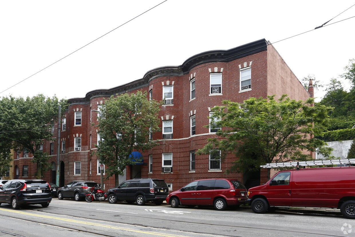
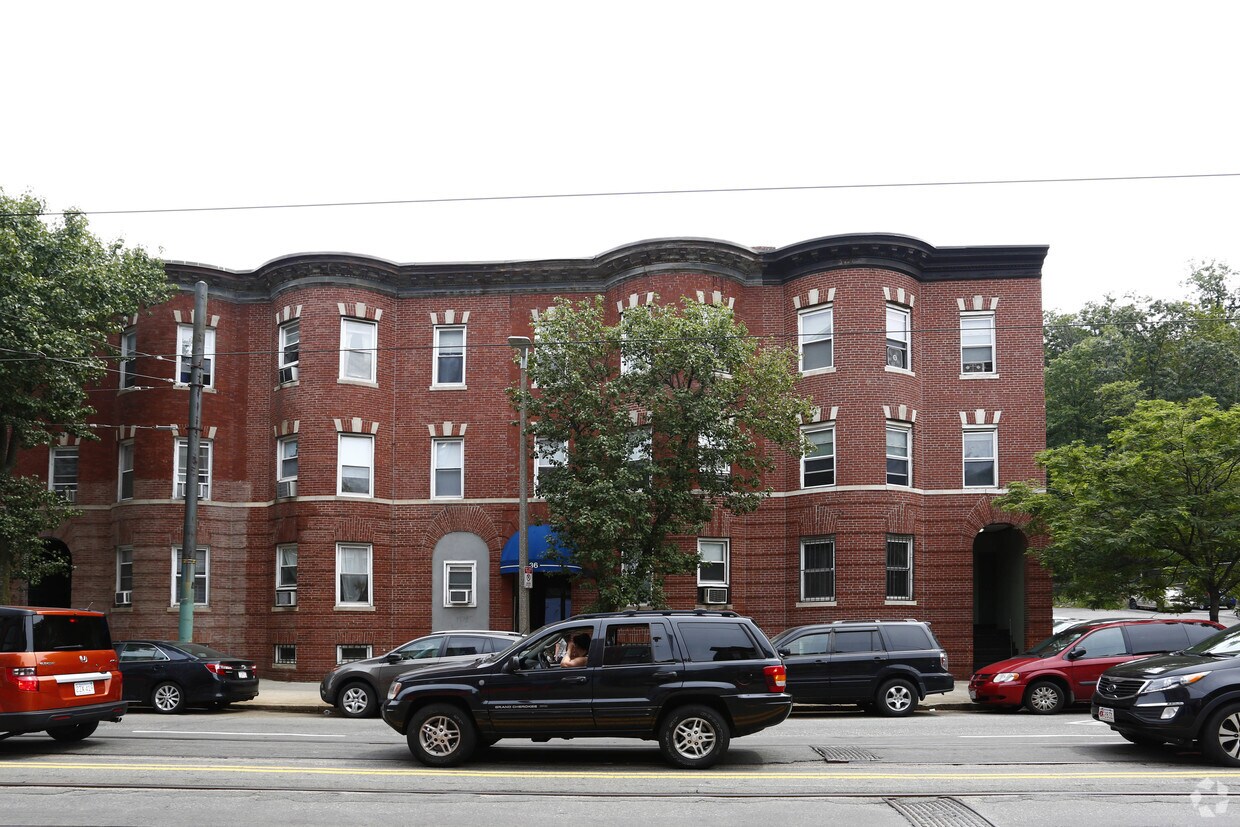
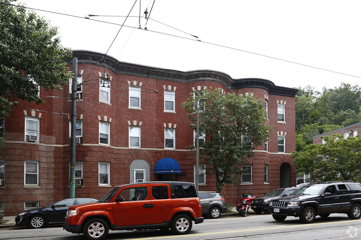
34-36 S Huntington Ave
34-36 S Huntington Ave,
Jamaica Plain,
MA
02130
2 Weeks Ago
Favorites
34-36 S Huntington Ave
Favorites
Check Back Soon for Upcoming Availability
Fees and Policies
Details
Property Information
-
Built in 1920
-
5 units/3 stories
About 34-36 S Huntington Ave Jamaica Plain, MA 02130
Discover your new home at 36 S Huntington Ave in Boston, MA. You'll find this community in the Mission Hill area of Boston. The professional leasing team is ready to help you find your new home. It's time to love where you live. Stop by for a visit today.
34-36 S Huntington Ave is an apartment community located in Suffolk County and the 02130 ZIP Code. This area is served by the Boston Public Schools attendance zone.
Location
Get Directions
Widely recognized as one of Boston’s greenest and most diverse neighborhoods, Jamaica Plain (or “JP,” as locals call it) is surrounded by the city’s “Emerald Necklace” of parks. For residents in search of a respite from the busy streets and high energy of city life, Jamaica Plain offers a green getaway. Popular parks that surround the area include Olmsted Park, Southwest Corridor Park, and Mozart Park. Harvard’s Arnold Arboretum is one of the main attractions, taking up a large portion of the neighborhood’s south end. Much of the dining and entertainment lies along Centre Street, in the middle and northern sections of the neighborhood. Rail service connects Jamaica Plain to the rest of the Boston area, with several stops along the eastern edge of the neighborhood.
Professionals who inhabit this neighborhood love that JP is just 5 minutes outside of Downtown Boston. Commuting via car can be tricky – with busy streets and limited city parking, it may be easier to use rail service.
Learn more about living in Jamaica Plain
Education
| Colleges & Universities | Distance | ||
|---|---|---|---|
| Colleges & Universities | Distance | ||
| Walk: | 15 min | 0.8 mi | |
| Drive: | 2 min | 1.2 mi | |
| Drive: | 3 min | 1.4 mi | |
| Drive: | 3 min | 1.4 mi |
34-36 S Huntington Ave is within 15 minutes or 0.8 mile from MCPHS University, Boston. It is also near MassArt and Simmons College.
Schools


Public Elementary School
Grades PK-1
111 Students
Attendance Zone
Public Elementary & Middle School
Grades K-8
509 Students
Attendance Zone
Charter Elementary, Middle & High School
Grades 5-12
1,295 Students
Nearby
Public High School
Grades 9-12
377 Students
Nearby
Private Elementary, Middle & High School
Grades 3-10
109 Students
Nearby
Private Elementary & Middle School
Grades PK-8
235 Students
Nearby
Private Elementary, Middle & High School
Grades 5-12
471 Students
Nearby
School data provided by
 The GreatSchools Rating helps parents compare schools within a state based on a variety of school quality indicators and provides a helpful picture of how effectively each school serves all of its students. Ratings are on a scale of 1 (below average) to 10 (above average) and can include test scores, college readiness, academic progress, advanced courses, equity, discipline and attendance data. We also advise parents to visit schools, consider other information on school performance and programs, and consider family needs as part of the school selection process.
View GreatSchools Rating Methodology
View GreatSchools Rating Methodology
Transportation options available in Jamaica Plain include Riverway Station, located 0.0 mile from 34-36 S Huntington Ave. 34-36 S Huntington Ave is near General Edward Lawrence Logan International, located 7.4 miles or 14 minutes away.
| Transit / Subway | Distance | ||
|---|---|---|---|
| Transit / Subway | Distance | ||
|
|
Walk: | 2 min | 0.0 mi |
|
|
Walk: | 1 min | 0.1 mi |
|
|
Walk: | 4 min | 0.2 mi |
|
|
Walk: | 5 min | 0.3 mi |
|
|
Walk: | 7 min | 0.4 mi |
| Commuter Rail | Distance | ||
|---|---|---|---|
| Commuter Rail | Distance | ||
|
|
Drive: | 3 min | 1.5 mi |
|
|
Drive: | 6 min | 2.2 mi |
|
|
Drive: | 8 min | 2.6 mi |
|
|
Drive: | 9 min | 4.3 mi |
| Drive: | 15 min | 6.4 mi |
| Airports | Distance | ||
|---|---|---|---|
| Airports | Distance | ||
|
General Edward Lawrence Logan International
|
Drive: | 14 min | 7.4 mi |
Time and distance from 34-36 S Huntington Ave.
| Shopping Centers | Distance | ||
|---|---|---|---|
| Shopping Centers | Distance | ||
| Walk: | 13 min | 0.7 mi | |
| Drive: | 4 min | 1.4 mi | |
| Drive: | 4 min | 1.8 mi |
34-36 S Huntington Ave has 3 shopping centers within 1.8 miles, which is about a 4-minute walk. The miles and minutes will be for the farthest away property.
| Parks and Recreation | Distance | ||
|---|---|---|---|
| Parks and Recreation | Distance | ||
|
Frederick Law Olmsted National Historic Site
|
Drive: | 3 min | 1.3 mi |
|
Roxbury Heritage State Park
|
Drive: | 3 min | 1.5 mi |
|
John Fitzgerald Kennedy National Historic Site
|
Drive: | 4 min | 1.5 mi |
|
Coit Observatory
|
Drive: | 4 min | 2.2 mi |
|
Charles River Reservation
|
Drive: | 5 min | 2.6 mi |
34-36 S Huntington Ave has 5 parks within 2.6 miles, including Frederick Law Olmsted National Historic Site, Roxbury Heritage State Park, and John Fitzgerald Kennedy National Historic Site.
| Hospitals | Distance | ||
|---|---|---|---|
| Hospitals | Distance | ||
| Walk: | 10 min | 0.6 mi | |
| Walk: | 11 min | 0.6 mi | |
| Walk: | 15 min | 0.8 mi |
34-36 S Huntington Ave has 3 hospitals within 0.8 mile, the nearest is Brigham and Women's Hospital which is 0.6 mile away and a 10 minute walk.
| Military Bases | Distance | ||
|---|---|---|---|
| Military Bases | Distance | ||
| Drive: | 26 min | 14.3 mi | |
| Drive: | 30 min | 15.5 mi |
34-36 S Huntington Ave is 14.3 miles from US Military Reservation, and is convenient to other military bases, including Hanscom Air Force Base.
You May Also Like
Similar Rentals Nearby


What Are Walk Score®, Transit Score®, and Bike Score® Ratings?
Walk Score® measures the walkability of any address. Transit Score® measures access to public transit. Bike Score® measures the bikeability of any address.
What is a Sound Score Rating?
A Sound Score Rating aggregates noise caused by vehicle traffic, airplane traffic and local sources
Responded To This Review