


$3,045 / Month
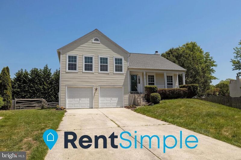
26 Brinks Ct
Sterling, VA 20165
2 Weeks Ago
Favorites
26 Brinks Ct

Favorites
Check Back Soon for Upcoming Availability
| Beds | Baths | Average SF |
|---|---|---|
| 4 Bedrooms 4 Bedrooms 4 Br | 3 Baths 3 Baths 3 Ba | 1,980 SF |
About This Property
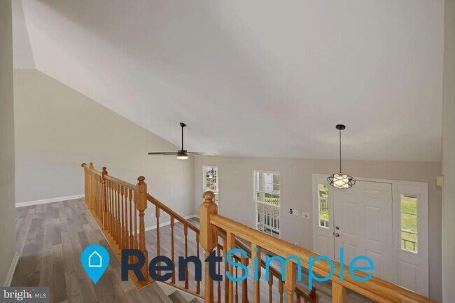
Professionally Leased and Managed by RentSimple – Apply and Reserve this Property Today – OCCUPIED HOME – SHOWINGS ONLY FOR APPROVED APPLICANTS. AVAILABLE FOR MOVE-IN: 4/1/2023. Fantastic 4 BD/3 BA Single-Family Home with Wooden Floors, Main Floor is Living Room, Kitchen and Bedroom are on Upper Floor, Breakfast Bar in Kitchen, Stainless Steel Appliances, Quartz Countertops, Mosaic Tile Backsplash, Modern Lighting, Lots of Natural Lighting, Kitchen Leads to Deck Overlooking Backyard and Trees, Master Bathroom with His and Her Sinks, Master Bedroom with Walk In Closet, Lower Level Features Large Recreational Space with Fireplace, Space Leads into Sunroom, Washer and Dryer on Lower Level, Spacious Fenced in Backyard, Easy Access to Rt. 28, Rt. 7, Nearby Natural Trails, Parks, Potomac River, Shopping, and Dining. This home has a 3D Tour for Virtual Viewings - Contact RentSimple for more info! All Applicants must Apply Online - Application available on RentSimple's website - Pets OK w/ weight limit restrictions. (Limit 3 – Add’l Pet Fee/Rent Applies)
26 Brinks Ct is a house located in Loudoun County and the 20165 ZIP Code. This area is served by the Loudoun County Public Schools attendance zone.
Location
Get Directions
While the name may inspire visions of rolling, green hills and cascading waterfalls, Countryside-Potomac Falls provides much more than a beautiful location for your Sterling apartment. It borders the Potomac River along the Virginia/Maryland line, then extends southward to Highway 7. The neighborhood is flanked by two popular parks: Bles Park and Algonkian Regional Park. Countryside-Potomac Falls is in northeastern Sterling, roughly 26 miles northwest of Washington, DC. With the nearby businesses of Sterling and the action of DC just minutes away, this fantastic area has grown rapidly since it was developed in the mid-1970s.
Taking full advantage of the area's natural beauty, Countryside-Potomac Falls offers several hiking trails, including the Countryside East River Trail, which connects to the Potomac Heritage Trail.
Learn more about living in Countryside-Potomac FallsBelow are rent ranges for similar nearby apartments
Education
| Colleges & Universities | Distance | ||
|---|---|---|---|
| Colleges & Universities | Distance | ||
| Drive: | 7 min | 3.4 mi | |
| Drive: | 8 min | 3.7 mi | |
| Drive: | 9 min | 4.1 mi | |
| Drive: | 48 min | 30.9 mi |
26 Brinks Ct is within 7 minutes or 3.4 miles from NOVA, Loudoun Campus. It is also near George Mason University and GWU, Virginia Sci. and Tech..
Schools


Public Elementary School
Grades PK-5
636 Students
Attendance Zone
Public Middle School
Grades 6-8
1,160 Students
Attendance Zone
Public High School
Grades 9-12
1,606 Students
Attendance Zone
Private Elementary, Middle & High School
Grades PK-12
475 Students
Nearby
Private Elementary & Middle School
Grades K-8
203 Students
Nearby
School data provided by
 The GreatSchools Rating helps parents compare schools within a state based on a variety of school quality indicators and provides a helpful picture of how effectively each school serves all of its students. Ratings are on a scale of 1 (below average) to 10 (above average) and can include test scores, college readiness, academic progress, advanced courses, equity, discipline and attendance data. We also advise parents to visit schools, consider other information on school performance and programs, and consider family needs as part of the school selection process.
View GreatSchools Rating Methodology
Data provided by GreatSchools.org © 2025. All rights reserved.
View GreatSchools Rating Methodology
Data provided by GreatSchools.org © 2025. All rights reserved.
Transportation options available in Sterling include Ashburn, Silver Line Center Platform, located 7.4 miles from 26 Brinks Ct. 26 Brinks Ct is near Washington Dulles International, located 9.5 miles or 19 minutes away, and Ronald Reagan Washington Ntl, located 30.6 miles or 48 minutes away.
| Transit / Subway | Distance | ||
|---|---|---|---|
| Transit / Subway | Distance | ||
| Drive: | 13 min | 7.4 mi | |
| Drive: | 14 min | 7.9 mi | |
| Drive: | 15 min | 8.6 mi | |
| Drive: | 20 min | 11.8 mi | |
| Drive: | 20 min | 12.2 mi |
| Commuter Rail | Distance | ||
|---|---|---|---|
| Commuter Rail | Distance | ||
|
Dickerson Marc Eb
|
Drive: | 49 min | 29.9 mi |
|
Dickerson Marc Eb
|
Drive: | 50 min | 30.0 mi |
|
|
Drive: | 59 min | 33.8 mi |
|
|
Drive: | 62 min | 39.9 mi |
| Drive: | 62 min | 40.0 mi |
| Airports | Distance | ||
|---|---|---|---|
| Airports | Distance | ||
|
Washington Dulles International
|
Drive: | 19 min | 9.5 mi |
|
Ronald Reagan Washington Ntl
|
Drive: | 48 min | 30.6 mi |
Time and distance from 26 Brinks Ct.
| Shopping Centers | Distance | ||
|---|---|---|---|
| Shopping Centers | Distance | ||
| Drive: | 5 min | 1.7 mi | |
| Drive: | 6 min | 2.8 mi | |
| Drive: | 7 min | 3.2 mi |
26 Brinks Ct has 3 shopping centers within 3.2 miles, which is about a 7-minute drive. The miles and minutes will be for the farthest away property.
| Parks and Recreation | Distance | ||
|---|---|---|---|
| Parks and Recreation | Distance | ||
|
Claude Moore Park
|
Drive: | 8 min | 3.7 mi |
|
Washington & Old Dominion Railroad Trail
|
Drive: | 8 min | 4.2 mi |
|
Algonkian Regional Park
|
Drive: | 13 min | 4.4 mi |
|
Red Rock Wilderness Regional Park
|
Drive: | 15 min | 8.9 mi |
|
Lake Newport
|
Drive: | 17 min | 9.4 mi |
26 Brinks Ct has 5 parks within 9.4 miles, including Claude Moore Park, Washington & Old Dominion Railroad Trail, and Algonkian Regional Park.
| Hospitals | Distance | ||
|---|---|---|---|
| Hospitals | Distance | ||
| Drive: | 10 min | 5.3 mi | |
| Drive: | 17 min | 9.1 mi |
26 Brinks Ct is 5.3 miles from Inova Loudoun Hospital, and is convenient to other hospitals, including Reston Hospital Center.
| Military Bases | Distance | ||
|---|---|---|---|
| Military Bases | Distance | ||
| Drive: | 46 min | 28.0 mi |
26 Brinks Ct is 28.0 miles and a 46 minute drive from Naval Observatory.
You May Also Like
Similar Rentals Nearby


What Are Walk Score®, Transit Score®, and Bike Score® Ratings?
Walk Score® measures the walkability of any address. Transit Score® measures access to public transit. Bike Score® measures the bikeability of any address.
What is a Sound Score Rating?
A Sound Score Rating aggregates noise caused by vehicle traffic, airplane traffic and local sources

26 Brinks Ct
Sterling, VA 20165