$3,150
Total Monthly Price
2015 Laurel Ave
Saint Paul, MN 55104
Favorites
952-886-7440
-
Bedrooms
6
-
Bathrooms
1.5
-
Square Feet
2,948 sq ft
-
Available
Available Jul 10
2015 Laurel Ave

Favorites
About This Home
$3,150 deposit,
Available Jul 10
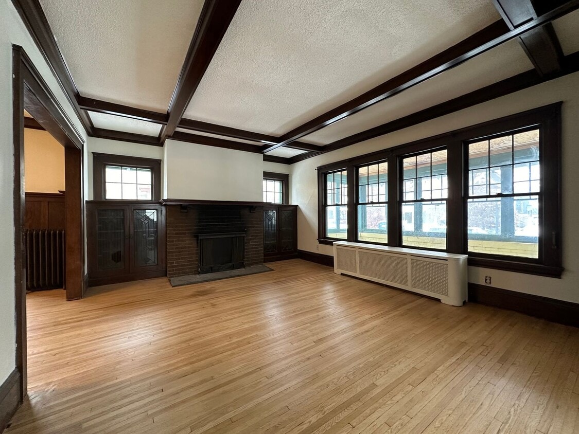
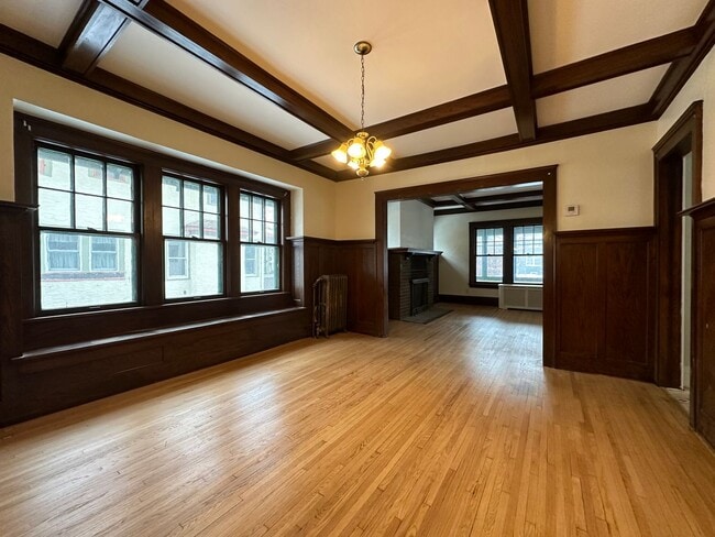
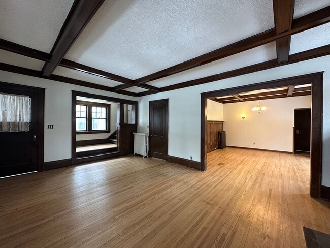
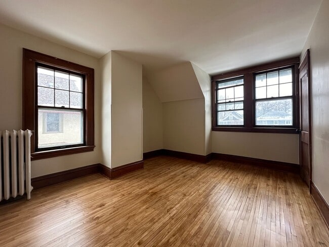
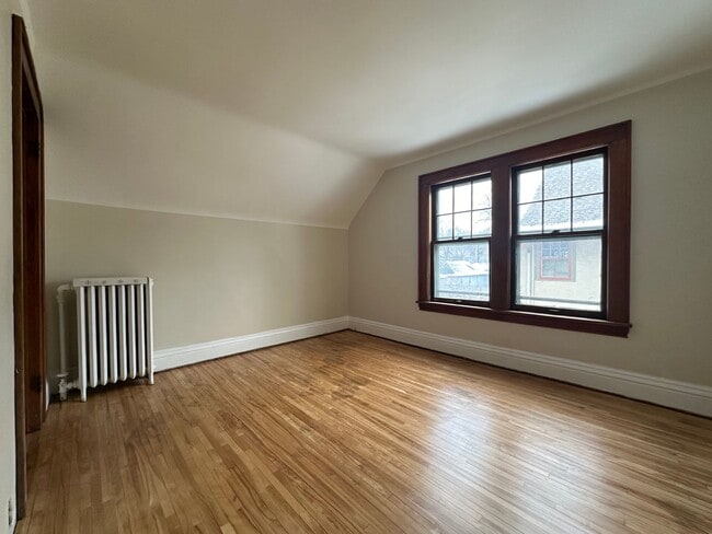
Welcome to this stunning single-family home located near University of St. Thomas in St. Paul, MN. Offering a spacious and inviting layout, this home features six bedrooms and three bathrooms, providing plenty of room for comfortable living, studying, or entertaining. Rich hardwood floors throughout add warmth and character, while the charming front porch creates the perfect space to relax and enjoy the neighborhood atmosphere. With generous living areas and timeless appeal, this home blends comfort and style in a highly convenient location near shopping, dining, and campus amenities. Don’t miss the chance to make this beautiful St. Paul home your next place to live. Elite Property Management Group Fees upon approval: -Application fee: $65 per adult -Deposit: One month's rent -One time non-refundable lease fee: $475 -Non-refundable pet fee: $475 per pet -Monthly Pet Rent: $45 per pet
Unique Features
- fireplace
- front porch
- hardwood floors
- None
- spacious
2015 Laurel Ave is a house located in Ramsey County and the 55104 ZIP Code. This area is served by the St. Paul Public School District attendance zone.
* Price shown is total price based on community-supplied monthly required fees. Excludes user-selected optional fees and variable or usage-based fees and required charges due at or prior to move-in or at move-out. Price, availability, fees, and any applicable rent special are subject to change without notice.
* Square footage definitions vary. Displayed square footage is approximate.
Fees and Policies
The fees listed below are community-provided and may exclude utilities or add-ons. All payments are made directly to the property and are non-refundable unless otherwise specified. Use the Cost Calculator to determine costs based on your needs.
-
One-Time Basics
-
Due at Move-In
-
Security Deposit - RefundableCharged per unit.$3,200
-
-
Due at Move-In
-
Dogs
-
Allowed
-
-
Cats
-
Allowed
-
Property Fee Disclaimer: Based on community-supplied data and independent market research. Subject to change without notice. May exclude fees for mandatory or optional services and usage-based utilities.
House Features
- Range
- Refrigerator
Contact
- Listed by Elite Property Management Group | Elite Property Management Group
- Phone Number
- Contact
Location
Get Directions
Along the shore of the Mississippi River, Merriam Park West offers riverfront parks, a large golf course, and quaint local restaurants just minutes from downtown Saint Paul, Minnesota. Stop on in at Izzy’s Ice Cream Café, or grab a treat at Black Coffee and Waffle Bar. Local businesses thrive alongside riverfront community spaces like Shadow Falls Park, a picturesque nature preserve.
The University of Saint Thomas resides on the south end of town, and the neighborhood offers a blend of private and public schools, churches, and every day conveniences. Situated just five miles southeast of Minneapolis and seven miles northeast of the Minneapolis-Saint Paul International Airport, this neighborhood is in a premier location for commuting, shopping, dining, and entertainment.
Learn more about living in Merriam Park West
Amenities
- Range
- Refrigerator
- fireplace
- front porch
- hardwood floors
- None
- spacious
Education
| Colleges & Universities | Distance | ||
|---|---|---|---|
| Colleges & Universities | Distance | ||
| Walk: | 10 min | 0.6 mi | |
| Drive: | 3 min | 1.7 mi | |
| Drive: | 3 min | 1.9 mi | |
| Drive: | 6 min | 1.9 mi |
2015 Laurel Ave is within 10 minutes or 0.6 mile from Univ. of St Thomas, St. Paul. It is also near Macalester College and Concordia Univ.-Saint Paul.
Schools


Public Elementary School
Grades PK-5
372 Students
Attendance Zone
Public Elementary School
Grades PK-5
266 Students
Nearby
Public Middle School
Grades 6-8
559 Students
Attendance Zone
Public High School
Grades 9-12
1,691 Students
Attendance Zone
Private Elementary & Middle School
Grades PK-8
186 Students
Nearby
Private Middle & High School
Grades 6-12
Nearby
School data provided by
 The GreatSchools Rating helps parents compare schools within a state based on a variety of school quality indicators and provides a helpful picture of how effectively each school serves all of its students. Ratings are on a scale of 1 (below average) to 10 (above average) and can include test scores, college readiness, academic progress, advanced courses, equity, discipline and attendance data. We also advise parents to visit schools, consider other information on school performance and programs, and consider family needs as part of the school selection process.
View GreatSchools Rating Methodology
Data provided by GreatSchools.org © 2026. All rights reserved.
View GreatSchools Rating Methodology
Data provided by GreatSchools.org © 2026. All rights reserved.
Transportation options available in Saint Paul include Fairview Ave Station, located 1.2 miles from 2015 Laurel Ave. 2015 Laurel Ave is near Minneapolis-St Paul International/Wold-Chamberlain, located 6.7 miles or 15 minutes away.
| Transit / Subway | Distance | ||
|---|---|---|---|
| Transit / Subway | Distance | ||
| Drive: | 2 min | 1.2 mi | |
| Drive: | 4 min | 1.7 mi | |
| Drive: | 5 min | 1.8 mi | |
| Drive: | 4 min | 2.1 mi | |
| Drive: | 5 min | 2.3 mi |
| Commuter Rail | Distance | ||
|---|---|---|---|
| Commuter Rail | Distance | ||
|
|
Drive: | 10 min | 5.7 mi |
|
|
Drive: | 14 min | 6.4 mi |
|
|
Drive: | 22 min | 14.9 mi |
|
|
Drive: | 32 min | 23.7 mi |
|
|
Drive: | 33 min | 25.4 mi |
| Airports | Distance | ||
|---|---|---|---|
| Airports | Distance | ||
|
Minneapolis-St Paul International/Wold-Chamberlain
|
Drive: | 15 min | 6.7 mi |
Getting Around
 What do Walkability, Transit, Drivability, and Bikeability mean?
Walkability measures the walking distance to day-to-day needs.
Transit measures access to public transportation.
Drivability measures congestion, parking availability, and access to major roads.
Bikeability measures the suitability for cycling.
How It Works
What do Walkability, Transit, Drivability, and Bikeability mean?
Walkability measures the walking distance to day-to-day needs.
Transit measures access to public transportation.
Drivability measures congestion, parking availability, and access to major roads.
Bikeability measures the suitability for cycling.
How It Works
Moderately Walkable
Walkability
60
/ 100
Some Public Transit
Transit
50
/ 100
Moderately Drivable
Drivability
70
/ 100
Moderately Bikeable
Bikeability
70
/ 100
Scores provided by
Active
Soundscore™
76
/ 100
Traffic
ActiveAirport
ActiveBusinesses
CalmScores provided by
HowLoud What is a Sound Score Rating? A Sound Score Rating aggregates noise caused by vehicle traffic, airplane traffic and local sources. How It WorksTime and distance from 2015 Laurel Ave.
| Shopping Centers | Distance | ||
|---|---|---|---|
| Shopping Centers | Distance | ||
| Drive: | 4 min | 1.8 mi | |
| Drive: | 5 min | 1.9 mi |
2015 Laurel Ave has 2 shopping centers within 1.9 miles, which is about a 5-minute drive. The miles and minutes will be for the farthest away property.
| Parks and Recreation | Distance | ||
|---|---|---|---|
| Parks and Recreation | Distance | ||
|
Macalester College Observatory
|
Drive: | 3 min | 1.9 mi |
|
Brackett Park
|
Drive: | 6 min | 2.1 mi |
|
Newell Park
|
Drive: | 4 min | 2.1 mi |
|
Longfellow Park
|
Drive: | 6 min | 2.5 mi |
|
Hiawatha School Park
|
Drive: | 9 min | 3.1 mi |
2015 Laurel Ave has 5 parks within 3.1 miles, including Macalester College Observatory, Brackett Park, and Newell Park.
| Hospitals | Distance | ||
|---|---|---|---|
| Hospitals | Distance | ||
| Drive: | 8 min | 3.5 mi | |
| Drive: | 7 min | 3.7 mi | |
| Drive: | 7 min | 3.8 mi |
2015 Laurel Ave has 3 hospitals within 3.8 miles, the nearest is M Health Fairview University of Minnesota Medical Center - East Bank which is 3.5 miles away and a 8 minute drive.
| Military Bases | Distance | ||
|---|---|---|---|
| Military Bases | Distance | ||
| Drive: | 14 min | 5.4 mi |
2015 Laurel Ave is 5.4 miles and a 14 minute drive from Fort Snelling Military Reservation.
You May Also Like
Similar Rentals Nearby
-
-
4 Beds$9,950Total Monthly PriceTotal Monthly Price NewPrices include base rent and required monthly fees. Variable costs based on usage may apply.
-
4 Beds$3,675Total Monthly PriceTotal Monthly Price NewPrices include base rent and required monthly fees. Variable costs based on usage may apply.
-
-
 4 Beds$2,786Total Monthly PriceTotal Monthly Price NewPrices include required monthly fees of $56.Base Rent:4 Beds$2,729House for Rent
 -

-
 5 Beds$3,230Total Monthly PriceTotal Monthly Price NewPrices include required monthly fees of $134.Base Rent:5 Beds$3,095House for Rent
 -

-
 4 Beds$2,984Total Monthly PriceTotal Monthly Price NewPrices include required monthly fees of $134.Base Rent:4 Beds$2,849House for Rent
 -
 5 Beds$3,730Total Monthly PriceTotal Monthly Price NewPrices include required monthly fees of $134.Base Rent:5 Beds$3,595House for Rent


What Are Walk Score®, Transit Score®, and Bike Score® Ratings?
Walk Score® measures the walkability of any address. Transit Score® measures access to public transit. Bike Score® measures the bikeability of any address.
What is a Sound Score Rating?
A Sound Score Rating aggregates noise caused by vehicle traffic, airplane traffic and local sources.

2015 Laurel Ave
Saint Paul, MN 55104