
100 Van Ness
100 Van Ness Ave,
San Francisco, CA 94102
Studio - 2 Beds $3,252 - $6,754

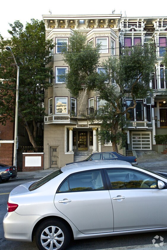
2011 Sacramento St is ready for you to move in. The 94109 location in San Francisco has much to offer its residents. This community has a wide variety of amenities including: high-speed internet access, convenient on-site parking options, and smoke free options. The team of leasing professionals is ready to help you find your perfect new home. Find your new home at 2011 Sacramento St. Stop by the leasing office to find out current pricing.
2011 Sacramento St is an apartment community located in San Francisco County and the 94109 ZIP Code. This area is served by the San Francisco Unified attendance zone.
Situated in northern San Francisco, Pacific Heights is a picturesque neighborhood known for its tranquil sophistication, Victorian architecture, and stunning views of the Golden Gate Bridge and the San Francisco Bay. Pacific Heights is a predominantly residential neighborhood, touting a host of apartments in colorful historic buildings as well as numerous extravagant homes along tree-lined streets.
Fillmore Street is the neighborhood’s major thoroughfare, regarded for its high-end boutique shopping and exceptional eateries. Pacific Heights exudes a peaceful atmosphere overall. Residents and visitors take to Alta Plaza Park and Lafayette Park to connect with nature in addition to the famous Presidio, which is adjacent to Pacific Heights. A walkable design along with access to public transit makes getting around from Pacific Heights a breeze.
Learn more about living in Pacific Heights| Colleges & Universities | Distance | ||
|---|---|---|---|
| Colleges & Universities | Distance | ||
| Walk: | 20 min | 1.0 mi | |
| Drive: | 4 min | 1.3 mi | |
| Drive: | 6 min | 2.0 mi | |
| Drive: | 6 min | 2.1 mi |


Transportation options available in San Francisco include Van Ness And California, located 0.3 mile from 2011 Sacramento St. 2011 Sacramento St is near San Francisco International, located 14.6 miles or 25 minutes away, and Metro Oakland International, located 20.4 miles or 33 minutes away.
| Transit / Subway | Distance | ||
|---|---|---|---|
| Transit / Subway | Distance | ||
|
|
Walk: | 5 min | 0.3 mi |
|
|
Walk: | 9 min | 0.5 mi |
|
|
Walk: | 10 min | 0.5 mi |
|
|
Walk: | 11 min | 0.6 mi |
|
|
Walk: | 13 min | 0.7 mi |
| Commuter Rail | Distance | ||
|---|---|---|---|
| Commuter Rail | Distance | ||
| Drive: | 7 min | 2.5 mi | |
| Drive: | 7 min | 2.5 mi | |
| Drive: | 9 min | 4.0 mi | |
| Drive: | 9 min | 4.0 mi | |
| Drive: | 13 min | 6.8 mi |
| Airports | Distance | ||
|---|---|---|---|
| Airports | Distance | ||
|
San Francisco International
|
Drive: | 25 min | 14.6 mi |
|
Metro Oakland International
|
Drive: | 33 min | 20.4 mi |
Time and distance from 2011 Sacramento St.
| Shopping Centers | Distance | ||
|---|---|---|---|
| Shopping Centers | Distance | ||
| Walk: | 8 min | 0.4 mi | |
| Walk: | 12 min | 0.6 mi | |
| Drive: | 4 min | 1.3 mi |
| Parks and Recreation | Distance | ||
|---|---|---|---|
| Parks and Recreation | Distance | ||
|
San Francisco Maritime National Historical Park
|
Drive: | 5 min | 1.6 mi |
|
Children's Creativity Museum
|
Drive: | 5 min | 1.8 mi |
|
Aquarium of The Bay
|
Drive: | 6 min | 2.2 mi |
|
Exploratorium
|
Drive: | 6 min | 2.4 mi |
|
Buena Vista Park
|
Drive: | 7 min | 2.4 mi |
| Hospitals | Distance | ||
|---|---|---|---|
| Hospitals | Distance | ||
| Walk: | 11 min | 0.6 mi | |
| Walk: | 12 min | 0.6 mi | |
| Drive: | 3 min | 1.4 mi |
| Military Bases | Distance | ||
|---|---|---|---|
| Military Bases | Distance | ||
| Drive: | 13 min | 4.4 mi | |
| Drive: | 14 min | 4.8 mi | |
| Drive: | 15 min | 6.5 mi |
What Are Walk Score®, Transit Score®, and Bike Score® Ratings?
Walk Score® measures the walkability of any address. Transit Score® measures access to public transit. Bike Score® measures the bikeability of any address.
What is a Sound Score Rating?
A Sound Score Rating aggregates noise caused by vehicle traffic, airplane traffic and local sources
2011 Sacramento St
San Francisco, CA 94109


