

$1,800
/ Month
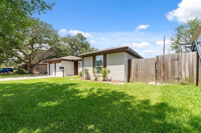
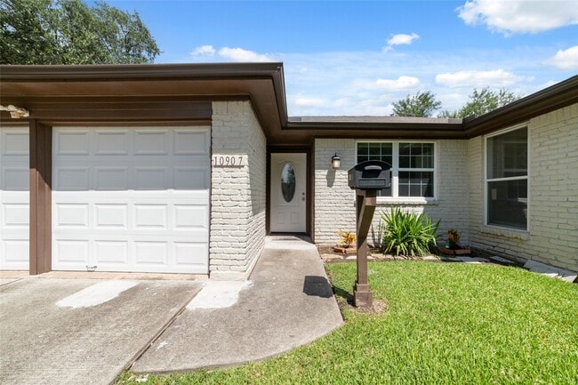
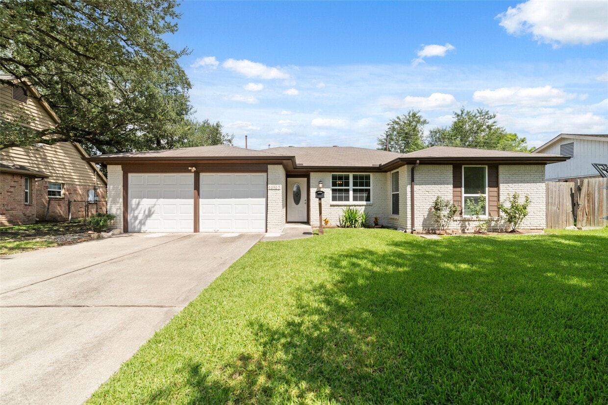
10907 Sageleaf Ln
Houston, TX 77089
Today
Favorites
281-701-8435
-
Bedrooms
3
-
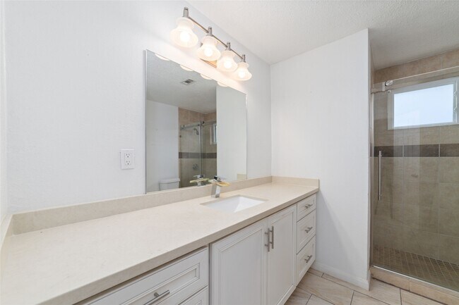
Bathrooms
2
-
Square Feet
1,685 sq ft
-
Available
Available Now
Highlights
- Traditional Architecture
- Granite Countertops
- Family Room Off Kitchen
- 2 Car Attached Garage
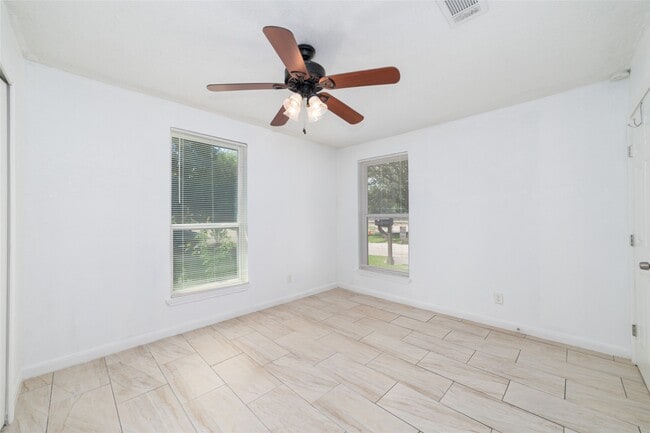
- Tile Flooring
- Kitchen Island
10907 Sageleaf Ln

Favorites
About This Home
Available Now
Gorgeous Single Story Home with 3 bedrooms and 2 baths that offers an open concept from kitchen to living area. Updated Features include: Recent roof,Fresh Paint,Cabinets with Granite Counter-tops,Covered Pergola/ Patio. Foundation Repair with warranty. Located conveniently to US 45,Beltway 8,610,Houston Downtown,Kemah,Galveston Beach MLS# 61355166
10907 Sageleaf Ln is a house located in Harris County and the 77089 ZIP Code. This area is served by the Pasadena Independent attendance zone.
* Price shown is base rent. Excludes user-selected optional fees and variable or usage-based fees and required charges due at or prior to move-in or at move-out. Price, availability, fees, and any applicable rent special are subject to change without notice.
* Square footage definitions vary. Displayed square footage is approximate.
Home Details
Home Type
Single Family Detached Home
Year Built
Built in 1966
Bedrooms and Bathrooms
2 Full Bathrooms
3 Bedrooms
Home Design
Traditional Architecture
Interior Spaces
Family Room Off Kitchen
Tile Flooring
1,685 Sq Ft Home
1-Story Property
Kitchen
Granite Countertops
Kitchen Island
Gas Range
Dishwasher
Listing and Financial Details
Property Available on 10/22/25
Long Term Lease
Lot Details
7,150 Sq Ft Lot
Parking
2 Car Attached Garage
Schools
Stuchbery Elementary School
Melillo Middle School
Dobie High School
Utilities
Central Heating and Cooling System
Heating System Uses Gas
Community Details
Overview
Sagemont Maintenance Association
Sagemont Sec 06 Subdivision
Pet Policy
No Pets Allowed
Contact
- Listed by Hung Pham | The Realty
- Phone Number
- Contact
-
Source
 Houston Association of REALTORS®
Copyright © 2025 Houston Association of Realtors. All rights reserved. All information provided by the listing agent/broker is deemed reliable but is not guaranteed and should be independently verified.
Location
Get Directions
Southbelt Ellington is a large neighborhood located about 20 miles southeast of Downtown Houston. Southbelt Ellington is known as one of the best neighborhoods to live in the city. Residents in this suburban, family-friendly area have access to good schools, parks, and plenty of amenities. Locals flock to Gulf Freeway for restaurants, wholesale clubs, and shopping centers like Almeda Mall. Great for any renter, Southbelt Ellington has various affordable and upscale rental options available.
The neighborhood is also known for being home to the Ellington Field Joint Reserve Base, which dominates the western side of Southbelt Ellington. Interstate 45 and Highway 8 intersect, making traveling into Downtown Houston and other neighborhoods easy. Whether residents commute to work or stay home, Southbelt-Ellington provides a home base with a well-rounded community feel.
Learn more about living in Southbelt-Ellington
Education
| Colleges & Universities | Distance | ||
|---|---|---|---|
| Colleges & Universities | Distance | ||
| Drive: | 6 min | 2.5 mi | |
| Drive: | 15 min | 9.6 mi | |
| Drive: | 19 min | 11.2 mi | |
| Drive: | 21 min | 14.8 mi |
10907 Sageleaf Ln is within 6 minutes or 2.5 miles from San Jacinto College, South. It is also near San Jacinto College, Central and Univ. of Houston Clear Lake.
Schools


Public Elementary School
Grades PK-4
596 Students
Attendance Zone
Public Elementary School
Grades 5-6
583 Students
Attendance Zone
Public Middle School
Grades 7-8
881 Students
Attendance Zone
Public High School
Grades 9-12
3,870 Students
Attendance Zone
Private Elementary School
Grades PK-5
75 Students
Nearby
Private Elementary & Middle School
Grades PK-8
35 Students
Nearby
Private Elementary, Middle & High School
Grades 2-11
Nearby
Private Elementary, Middle & High School
Grades PK-12
745 Students
Nearby
School data provided by
 The GreatSchools Rating helps parents compare schools within a state based on a variety of school quality indicators and provides a helpful picture of how effectively each school serves all of its students. Ratings are on a scale of 1 (below average) to 10 (above average) and can include test scores, college readiness, academic progress, advanced courses, equity, discipline and attendance data. We also advise parents to visit schools, consider other information on school performance and programs, and consider family needs as part of the school selection process.
View GreatSchools Rating Methodology
Data provided by GreatSchools.org © 2025. All rights reserved.
View GreatSchools Rating Methodology
Data provided by GreatSchools.org © 2025. All rights reserved.
Transportation options available in Houston include Palm Center Transit Ctr Sb, located 13.2 miles from 10907 Sageleaf Ln. 10907 Sageleaf Ln is near William P Hobby, located 6.2 miles or 15 minutes away, and George Bush Intcntl/Houston, located 37.6 miles or 46 minutes away.
| Transit / Subway | Distance | ||
|---|---|---|---|
| Transit / Subway | Distance | ||
| Drive: | 18 min | 13.2 mi |
| Commuter Rail | Distance | ||
|---|---|---|---|
| Commuter Rail | Distance | ||
|
|
Drive: | 23 min | 17.8 mi |
| Airports | Distance | ||
|---|---|---|---|
| Airports | Distance | ||
|
William P Hobby
|
Drive: | 15 min | 6.2 mi |
|
George Bush Intcntl/Houston
|
Drive: | 46 min | 37.6 mi |
Time and distance from 10907 Sageleaf Ln.
| Shopping Centers | Distance | ||
|---|---|---|---|
| Shopping Centers | Distance | ||
| Walk: | 5 min | 0.3 mi | |
| Walk: | 6 min | 0.4 mi | |
| Drive: | 3 min | 1.4 mi |
10907 Sageleaf Ln has 3 shopping centers within 1.4 miles, which is about a 3-minute walk. The miles and minutes will be for the farthest away property.
| Parks and Recreation | Distance | ||
|---|---|---|---|
| Parks and Recreation | Distance | ||
|
Sims Bayou Urban Nature Center
|
Drive: | 13 min | 9.0 mi |
|
Space Center Houston
|
Drive: | 18 min | 11.8 mi |
|
NASA-Johnson Space Center
|
Drive: | 21 min | 12.6 mi |
|
Armand Bayou Nature Center
|
Drive: | 19 min | 13.2 mi |
10907 Sageleaf Ln has 4 parks within 13.2 miles, including Sims Bayou Urban Nature Center, Space Center Houston, and NASA-Johnson Space Center.
| Hospitals | Distance | ||
|---|---|---|---|
| Hospitals | Distance | ||
| Drive: | 8 min | 5.7 mi | |
| Drive: | 12 min | 7.1 mi | |
| Drive: | 12 min | 9.0 mi |
10907 Sageleaf Ln has 3 hospitals within 9.0 miles, the nearest is CHI St Luke's Patients Medical Center which is 5.7 miles away and a 8 minute drive.
| Military Bases | Distance | ||
|---|---|---|---|
| Military Bases | Distance | ||
| Drive: | 20 min | 12.6 mi | |
| Drive: | 49 min | 38.1 mi |
10907 Sageleaf Ln is 12.6 miles from Lyndon B Johnson Space Center, and is convenient to other military bases, including Pelican Spit Military Reservation.
You May Also Like
Similar Rentals Nearby
-
-

-

-

-
-
-
1 / 50

-
-
-


What Are Walk Score®, Transit Score®, and Bike Score® Ratings?
Walk Score® measures the walkability of any address. Transit Score® measures access to public transit. Bike Score® measures the bikeability of any address.
What is a Sound Score Rating?
A Sound Score Rating aggregates noise caused by vehicle traffic, airplane traffic and local sources
10907 Sageleaf Ln
Houston, TX 77089