
IMT Cherry Creek
755 S Dexter St,
Denver, CO 80246
$1,765 - $2,375
1-2 Beds
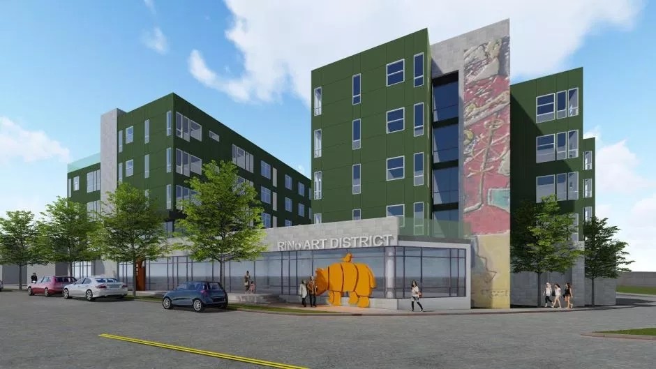
Experience Denver living at Walnut Flats. You'll find this community at 3773 Walnut St. in the RiNo area of Denver. Featuring 1 to 3 bedroom apartments. From amenities to availability, the leasing team is available to help you find your dream apartment. Stop by the leasing office to check the current floor plan availability.
Walnut Flats is an apartment community located in Denver County and the 80205 ZIP Code. This area is served by the Denver County 1 attendance zone.
Energetic, hip, vibrant, artistic -- there are plenty of words to describe RiNo (the River North Arts District), but the only way to truly get a feel for Denver's favorite neighborhood is to start experiencing it. RiNo contains some of Denver's top restaurants, the trendiest breweries and bars, the most talked-about art galleries, and the hottest shops and boutiques. With colorful murals and graffiti blending with just enough grit to keep things interesting, RiNo has become Denver's bohemian hub.
Art studios are everywhere in RiNo -- Elipse Gallery, Blue Silo Studios, ATC Den, Plinth Gallery, Helikon Gallery & Studios, Fice, Dateline, Studios on Blake, Studio Seven, and the Dry Ice Factory. It is also home to the Blue Moon Brewing Company, Great Divide Barrel Bar, Epic Brewing Company, First Draft Taproom and Kitchen, and Black Shirt Brewing. There are so many places to visit, you'll stay busy after moving to RiNo.
Learn more about living in RiNo| Colleges & Universities | Distance | ||
|---|---|---|---|
| Colleges & Universities | Distance | ||
| Drive: | 8 min | 3.0 mi | |
| Drive: | 8 min | 3.1 mi | |
| Drive: | 8 min | 3.1 mi | |
| Drive: | 10 min | 4.2 mi |


Transportation options available in Denver include 30Th-Downing, located 0.8 mile from Walnut Flats. Walnut Flats is near Denver International, located 22.1 miles or 30 minutes away.
| Transit / Subway | Distance | ||
|---|---|---|---|
| Transit / Subway | Distance | ||
|
|
Walk: | 15 min | 0.8 mi |
|
|
Drive: | 4 min | 1.4 mi |
|
|
Drive: | 4 min | 1.5 mi |
|
|
Drive: | 5 min | 1.9 mi |
|
|
Drive: | 6 min | 2.1 mi |
| Commuter Rail | Distance | ||
|---|---|---|---|
| Commuter Rail | Distance | ||
| Walk: | 3 min | 0.2 mi | |
| Drive: | 5 min | 1.6 mi | |
| Drive: | 10 min | 2.1 mi | |
| Drive: | 6 min | 2.1 mi | |
| Drive: | 6 min | 2.2 mi |
| Airports | Distance | ||
|---|---|---|---|
| Airports | Distance | ||
|
Denver International
|
Drive: | 30 min | 22.1 mi |
Time and distance from Walnut Flats.
| Shopping Centers | Distance | ||
|---|---|---|---|
| Shopping Centers | Distance | ||
| Walk: | 17 min | 0.9 mi | |
| Drive: | 4 min | 1.3 mi | |
| Drive: | 4 min | 1.5 mi |
| Parks and Recreation | Distance | ||
|---|---|---|---|
| Parks and Recreation | Distance | ||
|
Lower Downtown Historic District (LoDo)
|
Drive: | 5 min | 2.0 mi |
|
City of Axum Park
|
Drive: | 6 min | 2.4 mi |
|
Civic Center Park
|
Drive: | 8 min | 2.7 mi |
|
Denver Zoo
|
Drive: | 9 min | 2.9 mi |
|
City Park of Denver
|
Drive: | 10 min | 3.0 mi |
| Hospitals | Distance | ||
|---|---|---|---|
| Hospitals | Distance | ||
| Drive: | 5 min | 1.8 mi | |
| Drive: | 6 min | 2.0 mi | |
| Drive: | 9 min | 3.7 mi |
| Military Bases | Distance | ||
|---|---|---|---|
| Military Bases | Distance | ||
| Drive: | 44 min | 19.5 mi | |
| Drive: | 86 min | 68.0 mi | |
| Drive: | 95 min | 77.6 mi |
What Are Walk Score®, Transit Score®, and Bike Score® Ratings?
Walk Score® measures the walkability of any address. Transit Score® measures access to public transit. Bike Score® measures the bikeability of any address.
What is a Sound Score Rating?
A Sound Score Rating aggregates noise caused by vehicle traffic, airplane traffic and local sources

3773 Walnut St
Denver, CO 80205


