
sageLA - Brand New
200 N Vermont Ave,
Los Angeles, CA 90004
Studio - 2 Beds $2,345 - $4,836
Property Information Ideally located on the border of Monterey Hills and South Pasadena, this property offers beautiful mountain views and the best of urban living. This spacious building features modern amenities, including an in-unit washer and gas dryer hookup, a gas stove, a dishwasher, and a built-in microwave. You'll also enjoy easy access to all the area's conveniences, just 5 minutes from Old Town South Pasadena and 10 minutes to Downtown Los Angeles, with quick connections to the 110 freeway and the Gold Line. Enjoy the convenience of nearby shops, restaurants, and entertainment options. Situated next door to Arroyo Seco Park, you'll have access to 12 public tennis courts, a dog park, and scenic walking trails—ideal for you and your furry friends in our pet-friendly building Building Features: — Assigned Parking — Onsite Manager — Gated Community — Elevator Access — Central Air Conditioning — Laundry Hook-Ups — Laminate Flooring — Open Kitchen Concept With Quartz Countertops — Appliances Included: Gas Stove, Dishwasher, Built-In Microwave — Pet-Friendly Building Take advantage of this fantastic opportunity to live in comfort and style in one of LA's most desirable areas! Contact us today for a viewing.
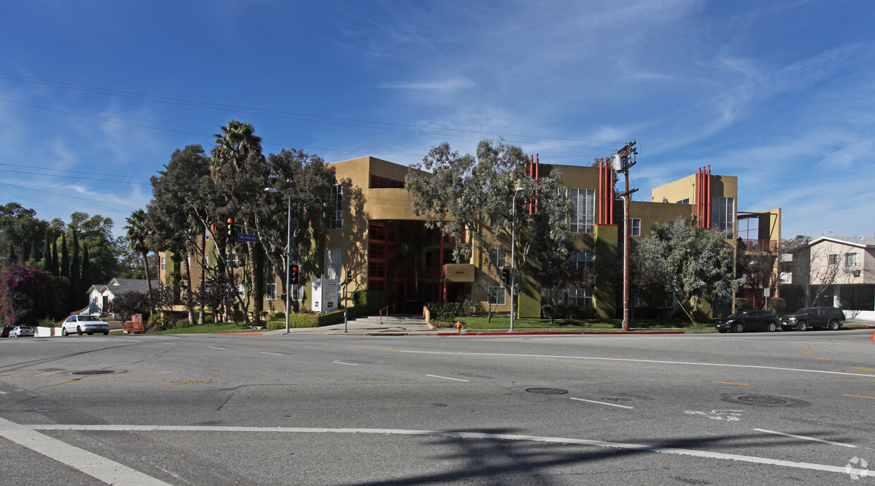
Monterey Via Marisol is an apartment community located in Los Angeles County and the 90042 ZIP Code. This area is served by the Los Angeles Unified attendance zone.
Elevator
Recycling
Gated
Property Manager on Site
Washer/Dryer
Air Conditioning
Dishwasher
Washer/Dryer Hookup
Loft Layout
Microwave
Refrigerator
Disposal
A quiet suburb outside of Los Angeles, Monterey Hills is known for its rolling hills, winding residential streets, and elevated city views. Check out Elephant Hill, a popular place to bike or hike that offers beautiful views of the neighborhood. Herman Park is nestled along Highway 110 in the north end of the neighborhood, offering tennis courts, playgrounds, and a dog park. And for more outdoor recreation, visit the biking paths and hiking trails at Ernest E. Debs Regional Park, bordering Monterey Hills.
Monterey Hills is a more secluded part of Northeast Los Angeles with larger lots, single-family homes, and tree-lined streets. However, if you cross over Highway 110, you’ll find theatres, restaurants, services, and more. Monterey Hills is located just seven miles northeast of Downtown Los Angeles and eight miles east of major attractions such as Griffith Park, the Los Angeles Zoo, the Greek Theatre, and Glendale Galleria.
Learn more about living in Monterey Hills| Colleges & Universities | Distance | ||
|---|---|---|---|
| Colleges & Universities | Distance | ||
| Drive: | 8 min | 3.1 mi | |
| Drive: | 6 min | 3.5 mi | |
| Drive: | 9 min | 4.0 mi | |
| Drive: | 11 min | 5.0 mi |


Transportation options available in Los Angeles include Highland Park Station, located 0.8 mile from Monterey Via Marisol. Monterey Via Marisol is near Bob Hope, located 17.3 miles or 24 minutes away, and Los Angeles International, located 20.4 miles or 32 minutes away.
| Transit / Subway | Distance | ||
|---|---|---|---|
| Transit / Subway | Distance | ||
|
|
Walk: | 16 min | 0.8 mi |
|
|
Drive: | 4 min | 2.1 mi |
|
|
Drive: | 5 min | 2.4 mi |
|
|
Drive: | 4 min | 2.5 mi |
|
|
Drive: | 5 min | 3.1 mi |
| Commuter Rail | Distance | ||
|---|---|---|---|
| Commuter Rail | Distance | ||
|
|
Drive: | 9 min | 5.3 mi |
|
|
Drive: | 11 min | 5.4 mi |
|
|
Drive: | 11 min | 6.6 mi |
| Drive: | 13 min | 9.4 mi | |
|
|
Drive: | 21 min | 13.6 mi |
| Airports | Distance | ||
|---|---|---|---|
| Airports | Distance | ||
|
Bob Hope
|
Drive: | 24 min | 17.3 mi |
|
Los Angeles International
|
Drive: | 32 min | 20.4 mi |
Time and distance from Monterey Via Marisol.
| Shopping Centers | Distance | ||
|---|---|---|---|
| Shopping Centers | Distance | ||
| Walk: | 12 min | 0.7 mi | |
| Drive: | 3 min | 1.2 mi | |
| Drive: | 3 min | 1.3 mi |
| Parks and Recreation | Distance | ||
|---|---|---|---|
| Parks and Recreation | Distance | ||
|
Audubon Center at Debs Park
|
Drive: | 3 min | 1.3 mi |
|
Kidspace Children's Museum
|
Drive: | 10 min | 5.0 mi |
|
Elysian Park
|
Drive: | 11 min | 5.1 mi |
|
Elyria Canyon Park
|
Drive: | 10 min | 5.3 mi |
|
Marsh Park
|
Drive: | 11 min | 5.6 mi |
| Hospitals | Distance | ||
|---|---|---|---|
| Hospitals | Distance | ||
| Drive: | 8 min | 3.7 mi | |
| Drive: | 9 min | 3.9 mi | |
| Drive: | 6 min | 3.9 mi |
| Military Bases | Distance | ||
|---|---|---|---|
| Military Bases | Distance | ||
| Drive: | 29 min | 21.9 mi | |
| Drive: | 42 min | 29.4 mi |
What Are Walk Score®, Transit Score®, and Bike Score® Ratings?
Walk Score® measures the walkability of any address. Transit Score® measures access to public transit. Bike Score® measures the bikeability of any address.
What is a Sound Score Rating?
A Sound Score Rating aggregates noise caused by vehicle traffic, airplane traffic and local sources

5907 Monterey Rd
Los Angeles, CA 90042


 - AVA Burbank")


