-
JEFFERSON AVENUE

-
-
$1,250
/ Month
339 Jefferson Ave Unit B
Brooklyn, NY 11216
2 Weeks Ago
|
Edit
Favorites
JEFFERSON AVENUE

Favorites
Check Back Soon for Upcoming Availability
| Beds | Baths | Average SF |
|---|---|---|
| Studio Studio 0 Br | 1 Bath 1 Bath 1 Ba | — |
About This Property
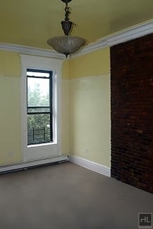
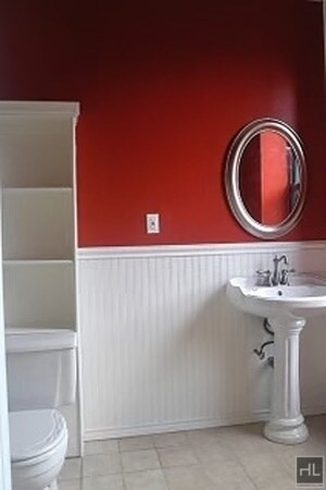
Small studioHardwood floors===Ref:858575===
JEFFERSON AVENUE is an apartment community located in Kings County and the 11216 ZIP Code.
339 Jefferson Ave,
Brooklyn,
NY
11216
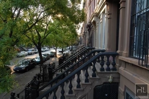
Bedford-Stuyvesant, often shortened to Bed-Stuy, sits in north central Brooklyn, touting plenty of classic brownstones along tree-lined streets. Bed-Stuy is revered for its historic architecture, containing one of the highest concentrations of Victorian properties in all of New York City.
Residents enjoy a strong sense of community in Bed-Stuy along with an array of diverse eateries, cafes, and bodegas. Herbert Von King Park lies at the center of the neighborhood, exuding a lively town-square atmosphere with an outdoor amphitheater, Cultural Arts Center, and athletic facilities. Convenience to public transportation and I-278 makes commuting and traveling from Bed-Stuy a breeze.
Learn more about living in Bedford-StuyvesantBelow are rent ranges for similar nearby apartments
| Beds | Average Size | Lowest | Typical | Premium |
|---|---|---|---|---|
| Studio Studio Studio | 1019 Sq Ft | $1,250 | $2,327 | $3,995 |
| 1 Bed 1 Bed 1 Bed | 809-813 Sq Ft | $1,200 | $3,175 | $5,110 |
| 2 Beds 2 Beds 2 Beds | 1201 Sq Ft | $1,450 | $3,243 | $6,057 |
| 3 Beds 3 Beds 3 Beds | 564 Sq Ft | $1,400 | $2,554 | $5,995 |
| 4 Beds 4 Beds 4 Beds | 251 Sq Ft | $1,060 | $1,657 | $10,750 |
Education
| Colleges & Universities | Distance | ||
|---|---|---|---|
| Colleges & Universities | Distance | ||
| Drive: | 6 min | 1.9 mi | |
| Drive: | 5 min | 1.9 mi | |
| Drive: | 5 min | 2.1 mi | |
| Drive: | 6 min | 2.7 mi |
JEFFERSON AVENUE is within 5 minutes or 1.9 miles from Pratt Institute. It is also near Saint Joseph's Coll, Brooklyn and Medgar Evers College, CUNY.
Transportation options available in Brooklyn include Kingston-Throop Avenues, located 0.4 mile from JEFFERSON AVENUE. JEFFERSON AVENUE is near LaGuardia, located 10.9 miles or 21 minutes away, and John F Kennedy International, located 11.1 miles or 23 minutes away.
| Transit / Subway | Distance | ||
|---|---|---|---|
| Transit / Subway | Distance | ||
|
|
Walk: | 8 min | 0.4 mi |
|
|
Walk: | 10 min | 0.5 mi |
|
|
Walk: | 14 min | 0.7 mi |
|
|
Walk: | 16 min | 0.9 mi |
|
|
Drive: | 4 min | 1.2 mi |
| Commuter Rail | Distance | ||
|---|---|---|---|
| Commuter Rail | Distance | ||
|
|
Walk: | 12 min | 0.6 mi |
|
|
Drive: | 6 min | 2.2 mi |
|
|
Drive: | 7 min | 2.7 mi |
|
|
Drive: | 15 min | 6.6 mi |
|
|
Drive: | 16 min | 6.8 mi |
| Airports | Distance | ||
|---|---|---|---|
| Airports | Distance | ||
|
LaGuardia
|
Drive: | 21 min | 10.9 mi |
|
John F Kennedy International
|
Drive: | 23 min | 11.1 mi |
Walkability Near JEFFERSON AVENUE
Getting Around
 What do Walkability, Transit, Drivability, and Bikeability mean?
Walkability measures the walking distance to day-to-day needs.
Transit measures access to public transportation.
Drivability measures congestion, parking availability, and access to major roads.
Bikeability measures the suitability for cycling.
How It Works
What do Walkability, Transit, Drivability, and Bikeability mean?
Walkability measures the walking distance to day-to-day needs.
Transit measures access to public transportation.
Drivability measures congestion, parking availability, and access to major roads.
Bikeability measures the suitability for cycling.
How It Works
Exceptionally Walkable
Walkability
100
/ 100
Exceptional Public Transit
Transit
100
/ 100
Fairly Drivable
Drivability
40
/ 100
Moderately Bikeable
Bikeability
70
/ 100
Scores provided by
-
Soundscore™
-
/ 100
Traffic
-Airport
-Businesses
-Scores provided by
HowLoud What is a Sound Score Rating? A Sound Score Rating aggregates noise caused by vehicle traffic, airplane traffic and local sources. How It WorksTime and distance from JEFFERSON AVENUE.
| Shopping Centers | Distance | ||
|---|---|---|---|
| Shopping Centers | Distance | ||
| Drive: | 7 min | 2.2 mi | |
| Drive: | 6 min | 2.2 mi |
JEFFERSON AVENUE has 2 shopping centers within 2.2 miles, which is about a 6-minute drive. The miles and minutes will be for the farthest away property.
| Parks and Recreation | Distance | ||
|---|---|---|---|
| Parks and Recreation | Distance | ||
|
Brooklyn Children's Museum
|
Walk: | 13 min | 0.7 mi |
|
Crispus Attucks Playground
|
Drive: | 2 min | 1.1 mi |
|
St. John's Park
|
Drive: | 4 min | 1.2 mi |
|
Hattie Carthan Garden
|
Drive: | 4 min | 1.3 mi |
|
Brooklyn Botanic Garden
|
Drive: | 6 min | 2.5 mi |
JEFFERSON AVENUE has 5 parks within 2.5 miles, including Hattie Carthan Garden, Brooklyn Children's Museum, and Crispus Attucks Playground.
| Hospitals | Distance | ||
|---|---|---|---|
| Hospitals | Distance | ||
| Walk: | 14 min | 0.7 mi | |
| Drive: | 5 min | 1.4 mi | |
| Drive: | 6 min | 2.5 mi |
JEFFERSON AVENUE has 3 hospitals within 2.5 miles, the nearest is Interfaith Medical Center which is 0.7 mile away and a 14 minute walk.
| Military Bases | Distance | ||
|---|---|---|---|
| Military Bases | Distance | ||
| Drive: | 18 min | 7.4 mi | |
| Drive: | 22 min | 9.2 mi |
JEFFERSON AVENUE is 7.4 miles from Governors Island Support Center, and is convenient to other military bases, including Fort Hamilton.
You May Also Like
Similar Rentals Nearby


What Are Walk Score®, Transit Score®, and Bike Score® Ratings?
Walk Score® measures the walkability of any address. Transit Score® measures access to public transit. Bike Score® measures the bikeability of any address.
What is a Sound Score Rating?
A Sound Score Rating aggregates noise caused by vehicle traffic, airplane traffic and local sources.
339 Jefferson Ave
Brooklyn, NY 11216