
The Vitagraph
1277 E 14th St,
Brooklyn, NY 11230
$2,770 - $4,308
1-3 Beds
Bedrooms
Studio - 1 bd
Bathrooms
1 ba
Square Feet
450 sq ft
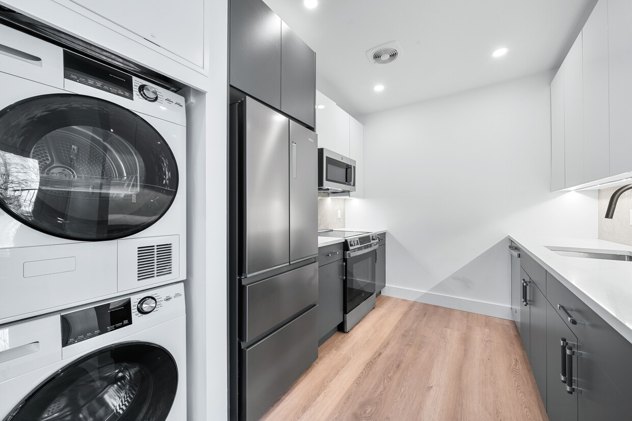
Brand-New Residences with In-Unit Laundry next to Clinton Hill and 30 seconds walk to A and C subway line’s Building Highlights • Brand-new construction • Modern design and finishes • Spacious, well-laid-out residences • Elevator • Bike Room Apartment Features • Large layouts • In-unit washer & dryer • Brand-new, modern appliances Neighborhood • Located at Fulton Street & Spencer Place • Between Clinton Hill and Bedford-Stuyvesant • Next to John Hancock Playground and 15 min walk to Prospect Park and Brooklyn Museum • Surrounded by popular restaurants, cafés, and shops including Speedy Romeo Furman’s Coffee and Peaches HotHouse •Gym across the street Transportation • 1 min walk to A and C line subway station and 12 min walk to G line
28 Spencer Place is an apartment community located in Kings County and the 11216 ZIP Code. This area is served by the New York City Geographic District #13 attendance zone.
Elevator
Playground
Controlled Access
24 Hour Access
Washer/Dryer
Air Conditioning
Dishwasher
Hardwood Floors
Walk-In Closets
Microwave
Refrigerator
Tub/Shower
Bedford-Stuyvesant, often shortened to Bed-Stuy, sits in north central Brooklyn, touting plenty of classic brownstones along tree-lined streets. Bed-Stuy is revered for its historic architecture, containing one of the highest concentrations of Victorian properties in all of New York City.
Residents enjoy a strong sense of community in Bed-Stuy along with an array of diverse eateries, cafes, and bodegas. Herbert Von King Park lies at the center of the neighborhood, exuding a lively town-square atmosphere with an outdoor amphitheater, Cultural Arts Center, and athletic facilities. Convenience to public transportation and I-278 makes commuting and traveling from Bed-Stuy a breeze.
Learn more about living in Bedford StuyvesantCompare neighborhood and city base rent averages by bedroom.
| Bedford-Stuyvesant | Brooklyn, NY | |
|---|---|---|
| Studio | $2,268 | $2,693 |
| 1 Bedroom | $2,705 | $3,044 |
| 2 Bedrooms | $3,203 | $3,972 |
| 3 Bedrooms | $3,925 | $4,922 |
| Colleges & Universities | Distance | ||
|---|---|---|---|
| Colleges & Universities | Distance | ||
| Walk: | 22 min | 1.2 mi | |
| Drive: | 2 min | 1.2 mi | |
| Drive: | 4 min | 1.3 mi | |
| Drive: | 4 min | 1.8 mi |


Transportation options available in Brooklyn include Franklin Avenue (A,C,S Line), located 0.1 mile from 28 Spencer Place. 28 Spencer Place is near LaGuardia, located 10.0 miles or 19 minutes away, and John F Kennedy International, located 11.3 miles or 23 minutes away.
| Transit / Subway | Distance | ||
|---|---|---|---|
| Transit / Subway | Distance | ||
|
|
Walk: | 1 min | 0.1 mi |
|
|
Walk: | 5 min | 0.3 mi |
|
|
Walk: | 11 min | 0.6 mi |
|
|
Walk: | 11 min | 0.6 mi |
|
|
Walk: | 14 min | 0.7 mi |
| Commuter Rail | Distance | ||
|---|---|---|---|
| Commuter Rail | Distance | ||
|
|
Walk: | 8 min | 0.5 mi |
|
|
Drive: | 3 min | 1.3 mi |
|
|
Drive: | 8 min | 2.9 mi |
|
|
Drive: | 13 min | 5.7 mi |
|
|
Drive: | 14 min | 5.9 mi |
| Airports | Distance | ||
|---|---|---|---|
| Airports | Distance | ||
|
LaGuardia
|
Drive: | 19 min | 10.0 mi |
|
John F Kennedy International
|
Drive: | 23 min | 11.3 mi |
Scores provided by
Traffic
BusyAirport
CalmBusinesses
BusyScores provided by
HowLoud What is a Sound Score Rating? A Sound Score Rating aggregates noise caused by vehicle traffic, airplane traffic and local sources. How It WorksTime and distance from 28 Spencer Place.
| Shopping Centers | Distance | ||
|---|---|---|---|
| Shopping Centers | Distance | ||
| Drive: | 4 min | 1.3 mi |
| Parks and Recreation | Distance | ||
|---|---|---|---|
| Parks and Recreation | Distance | ||
|
Crispus Attucks Playground
|
Walk: | 4 min | 0.3 mi |
|
Brooklyn Children's Museum
|
Walk: | 17 min | 0.9 mi |
|
Hattie Carthan Garden
|
Walk: | 19 min | 1.0 mi |
|
St. John's Park
|
Drive: | 4 min | 1.5 mi |
|
Brooklyn Botanic Garden
|
Drive: | 4 min | 1.6 mi |
| Hospitals | Distance | ||
|---|---|---|---|
| Hospitals | Distance | ||
| Drive: | 3 min | 1.1 mi | |
| Drive: | 3 min | 1.6 mi | |
| Drive: | 7 min | 2.2 mi |
| Military Bases | Distance | ||
|---|---|---|---|
| Military Bases | Distance | ||
| Drive: | 16 min | 6.5 mi | |
| Drive: | 19 min | 8.3 mi | |
| Drive: | 26 min | 13.7 mi |
What Are Walk Score®, Transit Score®, and Bike Score® Ratings?
Walk Score® measures the walkability of any address. Transit Score® measures access to public transit. Bike Score® measures the bikeability of any address.
What is a Sound Score Rating?
A Sound Score Rating aggregates noise caused by vehicle traffic, airplane traffic and local sources.

28 Spencer Place
Brooklyn, NY 11216


