
Bowling Brook Apartments
9000 Stebbing Way,
Laurel, MD 20723
$2,192 - $2,807
1-2 Beds

Modern designs, inviting interiors, and upscale amenities are the staples of The Crossings at Russett Apartments, a marquee destination for high-end living near Washington, D.C. Our apartments in Laurel benefit from an excellent address halfway between D.C. and Baltimore, so you can reach city conveniences with ease while enjoying peace and quiet whenever you return home.
Crossings at Russett is an apartment community located in Anne Arundel County and the 20724 ZIP Code. This area is served by the Anne Arundel County Public Schools attendance zone.
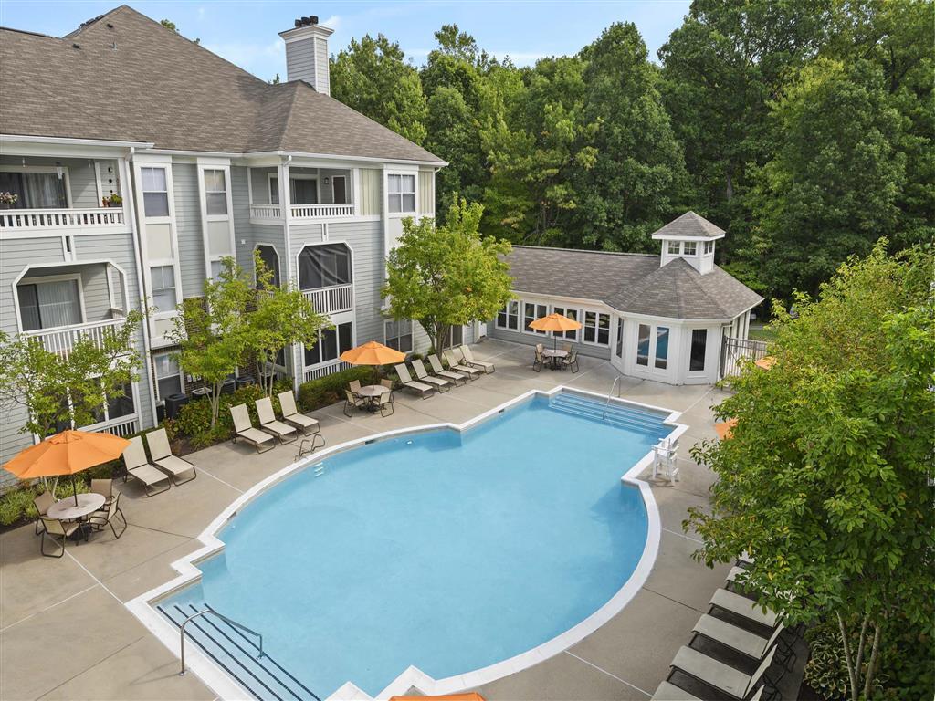
Unique Features
Pool
Fitness Center
Clubhouse
Lounge
Washer/Dryer
Air Conditioning
Dishwasher
Microwave
Located between Washington, D.C., and Baltimore, Laurel combines suburban living with easy access to major cities. The historic downtown area features a welcoming Main Street lined with independent businesses, while the Patuxent River winds through numerous parks and green spaces. The Laurel Lakes area offers outdoor recreation opportunities, and the Laurel Museum, housed in an 1840s mill workers' home, preserves the area's rich history. Housing options range from contemporary apartments near Towne Centre at Laurel to historic properties in the Old Town district. Current rental rates average $1,697 for one-bedroom units and $2,035 for two bedrooms, with year-over-year increases of 2.2% and 3.2% respectively.
Originally established as a mill town in the early 19th century, Laurel maintains strong connections to government and technology sectors, with NSA and Fort Meade located nearby.
Learn more about living in Laurel| Colleges & Universities | Distance | ||
|---|---|---|---|
| Colleges & Universities | Distance | ||
| Drive: | 18 min | 10.3 mi | |
| Drive: | 22 min | 12.9 mi | |
| Drive: | 24 min | 13.9 mi | |
| Drive: | 25 min | 16.0 mi |


Transportation options available in Laurel include Dorsey, located 9.6 miles from Crossings at Russett. Crossings at Russett is near Baltimore/Washington International Thurgood Marshall, located 12.6 miles or 21 minutes away, and Ronald Reagan Washington Ntl, located 25.7 miles or 40 minutes away.
| Transit / Subway | Distance | ||
|---|---|---|---|
| Transit / Subway | Distance | ||
|
|
Drive: | 16 min | 9.6 mi |
| Drive: | 21 min | 12.3 mi | |
|
|
Drive: | 21 min | 12.7 mi |
|
|
Drive: | 22 min | 12.9 mi |
| Commuter Rail | Distance | ||
|---|---|---|---|
| Commuter Rail | Distance | ||
| Drive: | 7 min | 2.7 mi | |
| Drive: | 8 min | 3.5 mi | |
|
|
Drive: | 9 min | 4.0 mi |
|
|
Drive: | 13 min | 7.0 mi |
|
|
Drive: | 13 min | 7.3 mi |
| Airports | Distance | ||
|---|---|---|---|
| Airports | Distance | ||
|
Baltimore/Washington International Thurgood Marshall
|
Drive: | 21 min | 12.6 mi |
|
Ronald Reagan Washington Ntl
|
Drive: | 40 min | 25.7 mi |
Time and distance from Crossings at Russett.
| Shopping Centers | Distance | ||
|---|---|---|---|
| Shopping Centers | Distance | ||
| Walk: | 14 min | 0.8 mi | |
| Walk: | 22 min | 1.1 mi | |
| Drive: | 4 min | 1.9 mi |
| Parks and Recreation | Distance | ||
|---|---|---|---|
| Parks and Recreation | Distance | ||
|
Patuxent Research Refuge - North Tract
|
Drive: | 8 min | 3.5 mi |
|
Fairland Regional Park
|
Drive: | 16 min | 7.9 mi |
|
Patuxent Research Refuge - South Tract
|
Drive: | 16 min | 8.1 mi |
|
NASA Goddard Space Flight Center
|
Drive: | 17 min | 9.3 mi |
|
Howard Owens Science Center
|
Drive: | 18 min | 10.4 mi |
| Hospitals | Distance | ||
|---|---|---|---|
| Hospitals | Distance | ||
| Drive: | 12 min | 5.5 mi | |
| Drive: | 20 min | 11.9 mi | |
| Drive: | 22 min | 14.1 mi |
| Military Bases | Distance | ||
|---|---|---|---|
| Military Bases | Distance | ||
| Drive: | 10 min | 5.0 mi |

Pets Allowed Fitness Center Pool Dishwasher In Unit Washer & Dryer

Pets Allowed Fitness Center In Unit Washer & Dryer Balcony Courtyard Concierge EV Charging
What Are Walk Score®, Transit Score®, and Bike Score® Ratings?
Walk Score® measures the walkability of any address. Transit Score® measures access to public transit. Bike Score® measures the bikeability of any address.
What is a Sound Score Rating?
A Sound Score Rating aggregates noise caused by vehicle traffic, airplane traffic and local sources
8500 Summit View Rd
Laurel, MD 20724


