
Montoya Garden
5005 Montoya Ave,
Richmond, CA 94805
$1,760 - $2,175
Studio - 2 Beds
Bedrooms
1 - 2 bd
Bathrooms
1 ba
Square Feet
725 - 800 sq ft

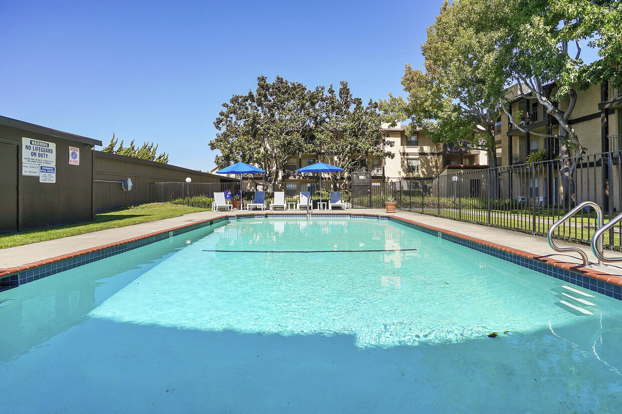
A great gas-saving location! We are just 6.5 miles from Berkeley, 8.5 miles from Emeryville, 10 miles from the Bay Bridge up highway 80. Located just off the El Portal Road exit from highway 80. Beautifully maintained apartments in San Pablo, with a lovely pool. Our large garden courtyard has a swimming pool with brand new brick, tile, and plaster. Lush landscaping with towering liquid amber trees, and mounds of fragrant star-jasmine. We have modern, bright and spacious one bedroom one bath, and two bedroom one bath, floor plans. State of the art laundry Internet connected machines. No more quarters, use your credit card at the machine! Availability can be checked online and notification when your laundry is done can be sent via text message or email. Take the guesswork out of your laundry and stop wasting time!
Casa Ensenada Apartments is an apartment community located in Contra Costa County and the 94806 ZIP Code. This area is served by the West Contra Costa Unified School District attendance zone.
Dishwasher
Microwave
Refrigerator
Tub/Shower
San Pablo sits at the geographic center of the East Bay, fully encircled by Richmond and positioned between San Francisco Bay to the west and Wildcat Canyon Regional Park to the east. The city carries a history that stretches from Ohlone settlement through Spanish rancho land grants, wartime industrial growth, and into its current identity as a dense, close-knit community in Contra Costa County. Contra Costa College anchors the city's commitment to accessible education and serves as a genuine community hub. San Pablo Lytton Casino adds an entertainment draw that few comparably sized cities can match.
With just three square miles to its name, San Pablo packs in a range of housing options, from ground-floor garden-style apartment communities to modest single-family rentals and smaller multi-unit buildings. The compact footprint means most daily errands are reachable without much effort.
Learn more about living in San Pablo| Colleges & Universities | Distance | ||
|---|---|---|---|
| Colleges & Universities | Distance | ||
| Walk: | 16 min | 0.8 mi | |
| Drive: | 17 min | 9.7 mi | |
| Drive: | 21 min | 10.8 mi | |
| Drive: | 24 min | 14.4 mi |


Transportation options available in San Pablo include Richmond Station, located 2.3 miles from Casa Ensenada Apartments. Casa Ensenada Apartments is near Metro Oakland International, located 22.8 miles or 32 minutes away, and San Francisco International, located 30.4 miles or 44 minutes away.
| Transit / Subway | Distance | ||
|---|---|---|---|
| Transit / Subway | Distance | ||
|
|
Drive: | 5 min | 2.3 mi |
|
|
Drive: | 7 min | 3.4 mi |
|
|
Drive: | 10 min | 5.5 mi |
|
|
Drive: | 15 min | 9.1 mi |
|
|
Drive: | 17 min | 9.8 mi |
| Commuter Rail | Distance | ||
|---|---|---|---|
| Commuter Rail | Distance | ||
| Drive: | 5 min | 2.5 mi | |
|
|
Drive: | 11 min | 7.9 mi |
| Drive: | 15 min | 10.2 mi | |
| Drive: | 21 min | 12.6 mi | |
| Drive: | 21 min | 13.5 mi |
| Airports | Distance | ||
|---|---|---|---|
| Airports | Distance | ||
|
Metro Oakland International
|
Drive: | 32 min | 22.8 mi |
|
San Francisco International
|
Drive: | 44 min | 30.4 mi |
Scores provided by
Traffic
ActiveAirport
CalmBusinesses
BusyScores provided by
HowLoud What is a Sound Score Rating? A Sound Score Rating aggregates noise caused by vehicle traffic, airplane traffic and local sources. How It WorksTime and distance from Casa Ensenada Apartments.
| Shopping Centers | Distance | ||
|---|---|---|---|
| Shopping Centers | Distance | ||
| Walk: | 3 min | 0.2 mi | |
| Walk: | 7 min | 0.4 mi | |
| Walk: | 11 min | 0.6 mi |
| Parks and Recreation | Distance | ||
|---|---|---|---|
| Parks and Recreation | Distance | ||
|
Point Pinole Regional Shoreline
|
Drive: | 7 min | 3.6 mi |
|
Marina Park & Green
|
Drive: | 8 min | 3.8 mi |
|
Rosie the Riveter WWII Home Front National Historical Park
|
Drive: | 9 min | 4.2 mi |
|
Shimada Friendship Park
|
Drive: | 9 min | 4.3 mi |
|
Wildcat Canyon Regional Park
|
Drive: | 13 min | 6.1 mi |
| Hospitals | Distance | ||
|---|---|---|---|
| Hospitals | Distance | ||
| Drive: | 20 min | 11.3 mi | |
| Drive: | 18 min | 12.3 mi |
| Military Bases | Distance | ||
|---|---|---|---|
| Military Bases | Distance | ||
| Walk: | 12 min | 0.6 mi | |
| Drive: | 13 min | 6.1 mi | |
| Drive: | 26 min | 16.8 mi |
Pets Allowed Fitness Center In Unit Washer & Dryer Stainless Steel Appliances Business Center Package Service Elevator
Pets Allowed Fitness Center In Unit Washer & Dryer Walk-In Closets Stainless Steel Appliances Hardwood Floors EV Charging
What Are Walk Score®, Transit Score®, and Bike Score® Ratings?
Walk Score® measures the walkability of any address. Transit Score® measures access to public transit. Bike Score® measures the bikeability of any address.
What is a Sound Score Rating?
A Sound Score Rating aggregates noise caused by vehicle traffic, airplane traffic and local sources.

2422-2444 Road 20
San Pablo, CA 94806


