
Parkway Lofts
5 Lawrence St,
Bloomfield, NJ 07003
$2,025 - $3,855
Studio - 2 Beds

Bedrooms
1 - 2 bd
Bathrooms
1 - 2 ba
Square Feet
750 - 1,331 sq ft
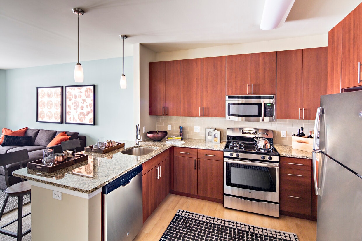
Avalon Bloomfield Station in Bloomfield, NJ features studio, 1, 2, and 3 bedroom apartment homes across the street from the Bloomfield NJ Transit Train Station. These brand new, pet friendly apartment homes include stainless steel appliances, granite countertops, in unit washer and dryer, and spacious walk-in closets. Community amenities include a state of the art fitness center with yoga studio, a rooftop patio lounge with BBQ gas grills, and a resident lounge with complimentary WiFi access. Property is convenient to hiking and jogging trails, ground floor retail that includes supermarket, dining, and specialty shops and located directly off exit 148 of the Garden State Parkway; close to I-280, I-80, Route 3, and Route 46.
Avalon Bloomfield Station is an apartment community located in Essex County and the 07003 ZIP Code. This area is served by the Bloomfield Board Of Education School District attendance zone.
Fitness Center
Grill
Lounge
Walking/Biking Trails
High Speed Internet Access
Walk-In Closets
Granite Countertops
Wi-Fi
Located 12 miles from Manhattan, Bloomfield combines small-town atmosphere with metropolitan accessibility. This Essex County township features established neighborhoods with housing options from classic single-family homes to contemporary apartment communities. The historic Bloomfield Green, anchored by the Presbyterian Church dating to 1794, serves as the town center. With two NJ Transit stations connecting to New York City and Newark, Bloomfield offers convenient transportation options for commuters. Current rental data shows one-bedroom apartments averaging $2,012, while three-bedroom units average $2,828.
Brookdale Park, spanning 77 acres, provides recreational opportunities with walking paths and athletic facilities. The downtown area near Bloomfield College features local shops and dining establishments. The Garden State Parkway and other major routes make commuting convenient from Bloomfield.
Learn more about living in Bloomfield| Colleges & Universities | Distance | ||
|---|---|---|---|
| Colleges & Universities | Distance | ||
| Walk: | 7 min | 0.4 mi | |
| Drive: | 7 min | 4.0 mi | |
| Drive: | 8 min | 4.2 mi | |
| Drive: | 8 min | 4.5 mi |

Transportation options available in Bloomfield include Grove Street, located 1.3 miles from Avalon Bloomfield Station. Avalon Bloomfield Station is near Newark Liberty International, located 9.8 miles or 16 minutes away, and LaGuardia, located 25.8 miles or 44 minutes away.
| Transit / Subway | Distance | ||
|---|---|---|---|
| Transit / Subway | Distance | ||
|
|
Drive: | 2 min | 1.3 mi |
|
|
Drive: | 4 min | 1.9 mi |
|
|
Drive: | 4 min | 1.9 mi |
|
|
Drive: | 4 min | 2.0 mi |
|
|
Drive: | 4 min | 2.2 mi |
| Commuter Rail | Distance | ||
|---|---|---|---|
| Commuter Rail | Distance | ||
|
|
Walk: | 4 min | 0.2 mi |
|
|
Walk: | 14 min | 0.7 mi |
|
|
Drive: | 2 min | 1.2 mi |
|
|
Drive: | 3 min | 1.6 mi |
|
|
Drive: | 5 min | 2.2 mi |
| Airports | Distance | ||
|---|---|---|---|
| Airports | Distance | ||
|
Newark Liberty International
|
Drive: | 16 min | 9.8 mi |
|
LaGuardia
|
Drive: | 44 min | 25.8 mi |
Time and distance from Avalon Bloomfield Station.
| Shopping Centers | Distance | ||
|---|---|---|---|
| Shopping Centers | Distance | ||
| Drive: | 3 min | 1.3 mi | |
| Drive: | 2 min | 1.3 mi | |
| Drive: | 3 min | 1.6 mi |
| Parks and Recreation | Distance | ||
|---|---|---|---|
| Parks and Recreation | Distance | ||
|
Branch Brook Park
|
Drive: | 6 min | 2.9 mi |
|
Van Vleck House & Gardens
|
Drive: | 5 min | 3.1 mi |
|
Edison National Historic Site
|
Drive: | 8 min | 3.2 mi |
|
Newark Museum and Dreyfuss Planetarium
|
Drive: | 7 min | 4.1 mi |
|
Presby Memorial Iris Gardens
|
Drive: | 9 min | 5.1 mi |
| Hospitals | Distance | ||
|---|---|---|---|
| Hospitals | Distance | ||
| Drive: | 5 min | 3.2 mi | |
| Drive: | 7 min | 4.0 mi | |
| Drive: | 8 min | 4.4 mi |
| Military Bases | Distance | ||
|---|---|---|---|
| Military Bases | Distance | ||
| Drive: | 22 min | 13.7 mi | |
| Drive: | 32 min | 15.7 mi | |
| Drive: | 37 min | 21.7 mi |
What Are Walk Score®, Transit Score®, and Bike Score® Ratings?
Walk Score® measures the walkability of any address. Transit Score® measures access to public transit. Bike Score® measures the bikeability of any address.
What is a Sound Score Rating?
A Sound Score Rating aggregates noise caused by vehicle traffic, airplane traffic and local sources.
300 Glenwood Ave
Bloomfield, NJ 07003


