
$2,700
/ Month
96 W 21st St
Bayonne, NJ 07002
Today
|
Edit
Favorites
773-317-0947
-
Bedrooms
3
-
Bathrooms
1
-
Square Feet
--
-
Available
Available Dec 16
Highlight
- Pets Allowed
96 W 21st St

Favorites
About This Home
Available Dec 16
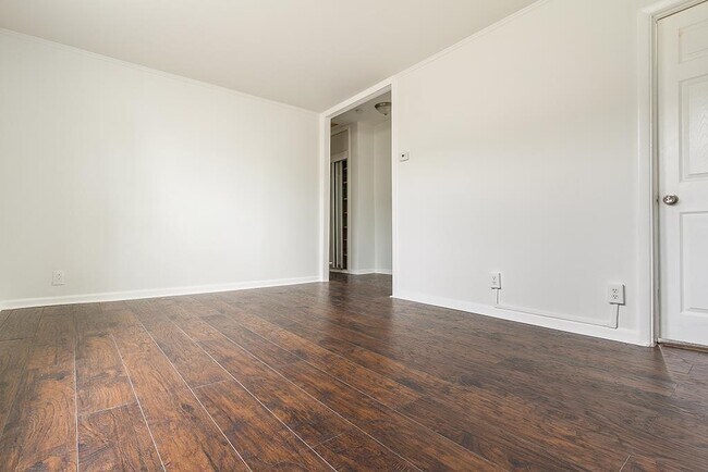
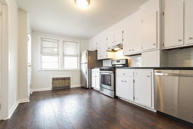
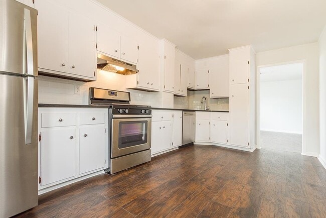
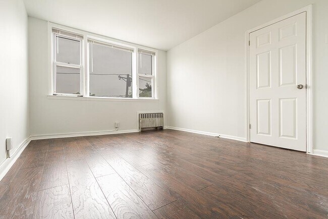
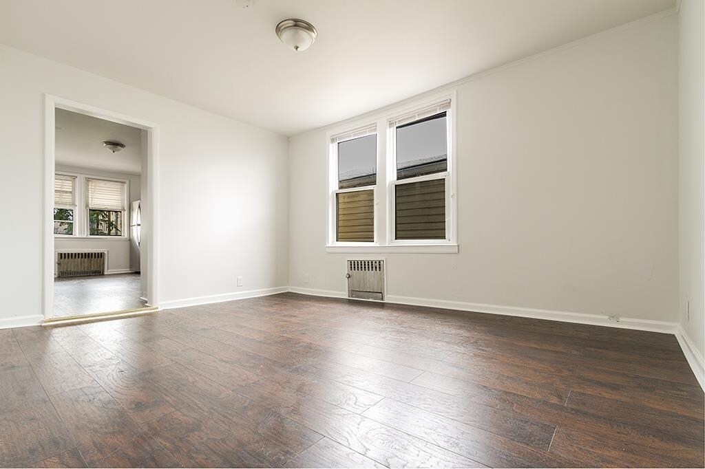
California King Sz Bedroom + Parking + Laundry! Pet-Friendly! Welcome to your Meticulously Pristine, 3 Bedroom unit which showcases Modern Living that transcends the ordinary; offering a harmonious blend of Contemporary Sophistication and Impeccable Craftsmanship throughout. Versatile, Open Living layout - PERFECT for seamless entertaining and relaxation! Create culinary delights in your Immaculate Chef's Kitchen - featuring abundant cabinetry, eat-in dining, granite countertops, and sun-drenched natural light. Serene Bathroom is spacious with sleek fixtures. 3 Opposite End bedrooms versatile as a Home Office, Gym/Fitness Room, or a Hobby Room. Nice Hallway Storage closet!! BONUS 1: Optional Parking - SUPER convenient in Midtown Bayonne! BONUS 2: Basement Laundry - a HUGE plus during winter! Desirable Location and Close Proximity! Excellent 82/100 Walk Score neighborhood rating for ease of errands and recreation! Bayonne is Hudson County's premier Boom Town, with an abundance of new real estate developments underway and upcoming Ferry Service to NYC. Nearby Newark Liberty International Airport, as well as Sports, Entertainment and Shopping delights: Prudential Center, Red Bull Arena, Newark Symphony Hall, NJPAC, MetLife Stadium, and American Dream Mall are within 30 mins. NYC Commuter's Dream! Enjoy your Convenient Lifestyle! 22nd St. Light Rail Station (connecting Bayonne to Jersey City, Hoboken, and PATH train to Manhattan), centrally located near Broadway/Ave C/Kennedy bus at corner to Port Authority, Rt. 440, Rt 1&9, I-78, I-95, NJ Turnpike. Shopper's Paradise! Enjoy a myriad of Local Neighborhood and Big Box retail shops, grocery, gourmet cafes, fast food, multi-cultural restaurant delights! ShopRite Grocery nearby!! Schools Nearby!! Outdoor Year-Round Waterfront Recreation abounds at 16th Street Park & nearby Stephen Gregg Park! A True Hudson County Gem! Schedule Your Showing Today!
Unique Features
- SharedYard
96 W 21st St is an apartment community located in Hudson County and the 07002 ZIP Code.
* Price shown is base rent. Excludes user-selected optional fees and variable or usage-based fees and required charges due at or prior to move-in or at move-out. Price, availability, fees, and any applicable rent special are subject to change without notice.
* Square footage definitions vary. Displayed square footage is approximate.
Fees and Policies
The fees below are based on community-supplied data and may exclude additional fees and utilities.
-
Dogs
-
Allowed
-
-
Cats
-
Allowed
-
Property Fee Disclaimer: Based on community-supplied data and independent market research. Subject to change without notice. May exclude fees for mandatory or optional services and usage-based utilities.
Features
- Oven
- Storage Space
Contact
- Listed by TUKEITHA SYLVERS | PROVIDENT LEGACY REAL ESTATE SERVICES LLC
- Phone Number
- Contact
-
Source
Hudson County Multiple Listing Service
Copyright © 2025 Hudson County Multiple Listing Service. All rights reserved. All information provided by the listing agent/broker is deemed reliable but is not guaranteed and should be independently verified.
Location
Get Directions
Amenities
- Oven
- Storage Space
- SharedYard
Also known as Constable's Hook, historic Constable Hook is one of New Jersey and the East Coast’s oldest communities. Nestled between the Hudson River and Newark Bay, Constable Hook consists of the southern portion of Bayonne. Bayonne prides itself on natural conservation and the area is home to several marinas and waterfront greenspaces. Golf fans spend days on the green at the Bayonne Golf Club, while Dennis P. Collins Park is a local favorite for its skatepark and views of the Bayonne Bridge and freight and cruise ships. Along Broadway, residents have access to restaurants, shops, and bars giving the area the feel of a small town. The neighborhood has a relatively low cost of living and has a variety of mid-range to upscale options available for rent.
Learn more about living in Constable Hook
Education
| Colleges & Universities | Distance | ||
|---|---|---|---|
| Colleges & Universities | Distance | ||
| Drive: | 9 min | 4.2 mi | |
| Drive: | 12 min | 5.4 mi | |
| Drive: | 17 min | 7.0 mi | |
| Drive: | 18 min | 9.5 mi |
96 W 21st St is within 9 minutes or 4.2 miles from New Jersey City University. It is also near Coll. of Staten Island, CUNY and Wagner College.
Transportation options available in Bayonne include 22Nd Street, located 0.5 mile from 96 W 21st St. 96 W 21st St is near Newark Liberty International, located 7.2 miles or 13 minutes away, and LaGuardia, located 19.6 miles or 39 minutes away.
| Transit / Subway | Distance | ||
|---|---|---|---|
| Transit / Subway | Distance | ||
|
|
Walk: | 9 min | 0.5 mi |
| Walk: | 17 min | 0.9 mi | |
|
|
Drive: | 3 min | 1.3 mi |
|
|
Drive: | 7 min | 3.1 mi |
|
|
Drive: | 7 min | 3.3 mi |
| Commuter Rail | Distance | ||
|---|---|---|---|
| Commuter Rail | Distance | ||
|
|
Drive: | 19 min | 7.6 mi |
|
|
Drive: | 18 min | 7.8 mi |
|
|
Drive: | 19 min | 8.2 mi |
|
|
Drive: | 18 min | 9.0 mi |
|
|
Drive: | 18 min | 10.1 mi |
| Airports | Distance | ||
|---|---|---|---|
| Airports | Distance | ||
|
Newark Liberty International
|
Drive: | 13 min | 7.2 mi |
|
LaGuardia
|
Drive: | 39 min | 19.6 mi |
Time and distance from 96 W 21st St.
| Shopping Centers | Distance | ||
|---|---|---|---|
| Shopping Centers | Distance | ||
| Walk: | 15 min | 0.8 mi | |
| Walk: | 16 min | 0.8 mi | |
| Walk: | 20 min | 1.0 mi |
96 W 21st St has 3 shopping centers within 1.0 miles, which is about a 20-minute walk. The miles and minutes will be for the farthest away property.
| Parks and Recreation | Distance | ||
|---|---|---|---|
| Parks and Recreation | Distance | ||
|
G. Thomas DiDomenico Park
|
Walk: | 8 min | 0.5 mi |
|
Stephen Gregg Park
|
Drive: | 6 min | 2.3 mi |
|
Faber Park
|
Drive: | 8 min | 3.8 mi |
|
Snug Harbor Cultural Center & Botanical Garden
|
Drive: | 13 min | 6.0 mi |
|
Staten Island Children's Museum
|
Drive: | 13 min | 6.0 mi |
96 W 21st St has 5 parks within 6.0 miles, including G. Thomas DiDomenico Park, Stephen Gregg Park, and Faber Park.
| Hospitals | Distance | ||
|---|---|---|---|
| Hospitals | Distance | ||
| Walk: | 16 min | 0.9 mi | |
| Drive: | 13 min | 5.9 mi | |
| Drive: | 12 min | 6.1 mi |
96 W 21st St has 3 hospitals within 6.1 miles, the nearest is Bayonne Medical Center which is 0.9 mile away and a 16 minute walk.
| Military Bases | Distance | ||
|---|---|---|---|
| Military Bases | Distance | ||
| Drive: | 7 min | 3.0 mi | |
| Drive: | 20 min | 7.8 mi |
96 W 21st St is 3.0 miles from Military Ocean Terminal, and is convenient to other military bases, including Naval Station NY Stapleton Site.
You May Also Like
How do I access Social Services in New Jersey?
Statewide service is free, confidential, multilingual and always open. Three easy ways to reach Social Services in NJ: Dial 2-1-1; text your zip code to 898-211; or chat at https://www.nj211.org
Similar Rentals Nearby
-
-
-
-
-
1 / 22

-
-
-
-
-


What Are Walk Score®, Transit Score®, and Bike Score® Ratings?
Walk Score® measures the walkability of any address. Transit Score® measures access to public transit. Bike Score® measures the bikeability of any address.
What is a Sound Score Rating?
A Sound Score Rating aggregates noise caused by vehicle traffic, airplane traffic and local sources
96 W 21st St
Bayonne, NJ 07002