
$2,150
/ Month
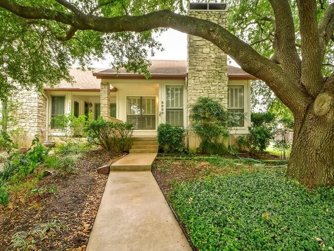
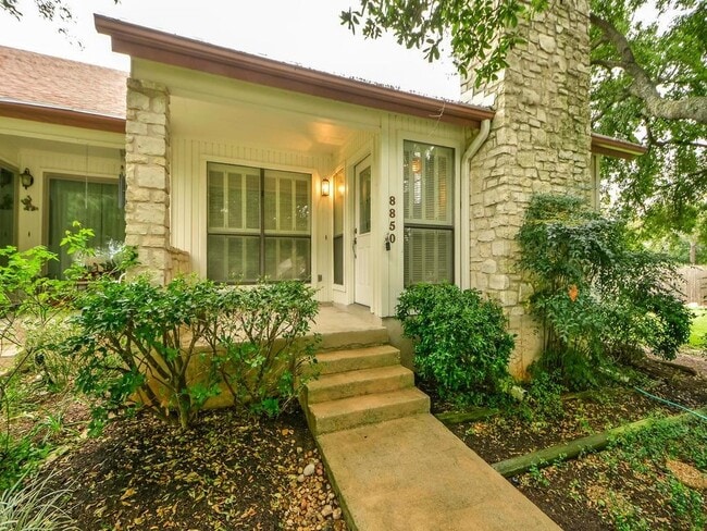
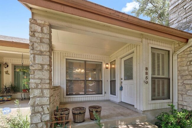
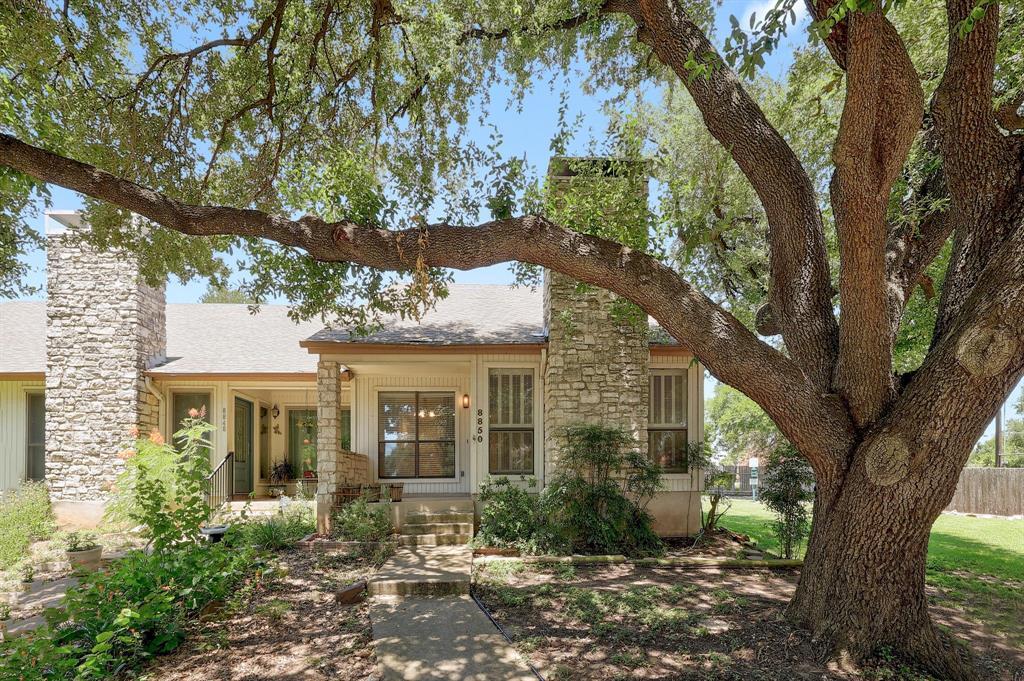
8850 Honeysuckle Trail
Austin, TX 78759
Today
Favorites
512-658-0045
-
Bedrooms
2
-
Bathrooms
2
-
Square Feet
1,209 sq ft
-
Available
Available Now
Highlights
- Mature Trees
- Vaulted Ceiling
- Community Pool
- 2 Car Detached Garage
- Cul-De-Sac
- Plantation Shutters
8850 Honeysuckle Trail

Favorites
About This Home
Available Now
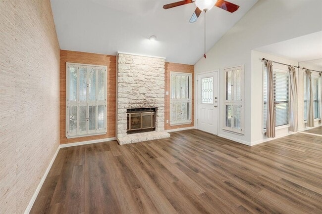
Quaint & private stone townhome 2 Bed 2 Bath in the cul de sac of Westover Villas with towering oaks. End unit and neighbor only on one side. Main level recent luxury vinyl plank flooring and carpet, grasscloth wallpaper and stone fireplace. Primary bedroom upstairs with full bath, separate vanity & large walk-in closet and secondary bed/bath downstairs on main level. Includes washer, dryer, 2 car garage and community pool. Owner/Agent.
8850 Honeysuckle Trail is a townhome located in Travis County and the 78759 ZIP Code. This area is served by the Austin Independent attendance zone.
* Price shown is base rent and may not include non-optional fees and utilities. Price, availability, fees, and any applicable rent special are subject to change without notice.
* Square footage definitions vary. Displayed square footage is approximate.
Home Details
Home Type
Townhome
Year Built
Built in 1982
Bedrooms and Bathrooms
In-Law or Guest Suite
Walk-In Closet
2 Bedrooms | 1 Main Level Bedroom
2 Full Bathrooms
Flooring
Carpet
Vinyl
Home Design
Stone Siding
Composition Roof
Slab Foundation
Frame Construction
Home Security
Fire and Smoke Detector
Interior Spaces
Family Room with Fireplace
Vaulted Ceiling
Plantation Shutters
1,209 Sq Ft Home
2-Story Property
Kitchen
Electric Range
Free-Standing Range
Microwave
Dishwasher
Disposal
Listing and Financial Details
Security Deposit $2,275
12 Month Lease Term
$50 Application Fee
Assessor Parcel Number 02480302510000
Tenant pays for all utilities
The owner pays for association fees, taxes
Lot Details
3,877 Sq Ft Lot
Mature Trees
Cul-De-Sac
South Facing Home
Sprinkler System
Outdoor Features
Porch
Parking
2 Car Detached Garage
Single Garage Door
Outside Parking
Garage Door Opener
Schools
Hill Elementary School
Murchison Middle School
Anderson High School
Utilities
Central Air
Heating Available
Electric Water Heater
Vented Exhaust Fan
Community Details
Overview
Property has a Home Owners Association
Westover Villa Resub Subdivision
Pet Policy
Pets allowed on a case-by-case basis
Pet Deposit $300
Recreation
Community Pool
Fees and Policies
The fees below are based on community-supplied data and may exclude additional fees and utilities.
Pet policies are negotiable.
Contact
- Listed by Elizabeth Riley | eXp Realty, LLC
- Phone Number
- Contact
-
Source
 Austin Board of REALTORS®
The information included in this listing is provided exclusively for consumers’ personal, non-commercial use and may not be used for any purpose other than to identify prospective properties consumers may be interested in purchasing. The information on each listing is furnished by the owner and deemed reliable to the best of his/her knowledge, but should be verified by the purchaser. ABoR, ACTRIS and Estately assume no responsibility for typographical errors, misprints or misinformation. This property listing is offered without respect to any protected classes in accordance with the law. Copyright © 2025.
Location
Get Directions
Amenities
- Dishwasher
- Disposal
- Microwave
- Refrigerator
- Carpet
- Vinyl Flooring
Among the suburbs of north Austin, Westover Hills is in a unique position. The neighborhood sits between the MoPac Expressway and the Bull Creek District Park, sandwiching itself between some fantastic retail opportunities and outdoor destinations.
Westover Hills is characterized by its wide streets and towering trees, plus a variety of homes and apartments that exhibit a number of different architectural styles. Look out for the popular watering holes that border the neighborhood, like Torchy’s Tacos and Luby’s cafeteria-style cafe, both of which provide authentic yet different culinary representations of Texas.
With the Bull Creek District Park and St. Edward’s Park just beyond it, a scenic hike or jog is minutes outside your front door. Downtown Austin is close too, just 15 minutes south via the expressway.
Learn more about living in Westover Hills
Education
| Colleges & Universities | Distance | ||
|---|---|---|---|
| Colleges & Universities | Distance | ||
| Drive: | 12 min | 4.7 mi | |
| Drive: | 12 min | 8.3 mi | |
| Drive: | 15 min | 9.1 mi | |
| Drive: | 22 min | 12.0 mi |
8850 Honeysuckle Trail is within 12 minutes or 4.7 miles from Austin C.C., Northridge Campus. It is also near University of Texas at Austin and Austin C.C., Rio Grande Campus.
Schools


Public Elementary School
Grades PK-5
842 Students
Attendance Zone
Public Middle School
Grades 6-8
1,237 Students
Attendance Zone
Public High School
Grades 9-12
2,210 Students
Attendance Zone
Private Elementary & Middle School
Grades K-8
95 Students
Nearby
Private Elementary School
Grades K-6
Nearby
Private Elementary School
Grades PK-1
84 Students
Nearby
Private High School
Grades 6 & 9-12
Nearby
School data provided by
 The GreatSchools Rating helps parents compare schools within a state based on a variety of school quality indicators and provides a helpful picture of how effectively each school serves all of its students. Ratings are on a scale of 1 (below average) to 10 (above average) and can include test scores, college readiness, academic progress, advanced courses, equity, discipline and attendance data. We also advise parents to visit schools, consider other information on school performance and programs, and consider family needs as part of the school selection process.
View GreatSchools Rating Methodology
Data provided by GreatSchools.org © 2025. All rights reserved.
View GreatSchools Rating Methodology
Data provided by GreatSchools.org © 2025. All rights reserved.
Transportation options available in Austin include Kramer Station, located 3.5 miles from 8850 Honeysuckle Trail. 8850 Honeysuckle Trail is near Austin-Bergstrom International, located 21.0 miles or 33 minutes away.
| Transit / Subway | Distance | ||
|---|---|---|---|
| Transit / Subway | Distance | ||
| Drive: | 8 min | 3.5 mi | |
| Drive: | 10 min | 3.9 mi | |
| Drive: | 10 min | 4.5 mi | |
| Drive: | 11 min | 5.1 mi | |
| Drive: | 12 min | 6.6 mi |
| Commuter Rail | Distance | ||
|---|---|---|---|
| Commuter Rail | Distance | ||
|
|
Drive: | 14 min | 9.0 mi |
|
|
Drive: | 40 min | 30.6 mi |
| Airports | Distance | ||
|---|---|---|---|
| Airports | Distance | ||
|
Austin-Bergstrom International
|
Drive: | 33 min | 21.0 mi |
Time and distance from 8850 Honeysuckle Trail.
| Shopping Centers | Distance | ||
|---|---|---|---|
| Shopping Centers | Distance | ||
| Drive: | 4 min | 1.3 mi | |
| Drive: | 5 min | 1.5 mi | |
| Drive: | 6 min | 2.4 mi |
8850 Honeysuckle Trail has 3 shopping centers within 2.4 miles, which is about a 6-minute drive. The miles and minutes will be for the farthest away property.
| Parks and Recreation | Distance | ||
|---|---|---|---|
| Parks and Recreation | Distance | ||
|
Bull Creek Greenbelt
|
Drive: | 6 min | 2.7 mi |
|
The Stephen F. Austin Planetarium
|
Drive: | 7 min | 2.7 mi |
|
Beverly S. Sheffield Northwest District Park
|
Drive: | 9 min | 3.4 mi |
|
Balcones District Park
|
Drive: | 10 min | 4.3 mi |
|
Great Hills Park
|
Drive: | 12 min | 4.4 mi |
8850 Honeysuckle Trail has 5 parks within 4.4 miles, including Bull Creek Greenbelt, The Stephen F. Austin Planetarium, and Beverly S. Sheffield Northwest District Park.
| Hospitals | Distance | ||
|---|---|---|---|
| Hospitals | Distance | ||
| Drive: | 6 min | 2.3 mi | |
| Drive: | 5 min | 2.5 mi | |
| Drive: | 9 min | 4.2 mi |
8850 Honeysuckle Trail has 3 hospitals within 4.2 miles, the nearest is Seton Northwest Hospital which is 2.3 miles away and a 6 minute drive.
| Military Bases | Distance | ||
|---|---|---|---|
| Military Bases | Distance | ||
| Drive: | 86 min | 67.9 mi | |
| Drive: | 93 min | 75.5 mi |
8850 Honeysuckle Trail is 67.9 miles from Fort Hood, and is convenient to other military bases, including Randolph Air Force Base.
You May Also Like
Similar Rentals Nearby


What Are Walk Score®, Transit Score®, and Bike Score® Ratings?
Walk Score® measures the walkability of any address. Transit Score® measures access to public transit. Bike Score® measures the bikeability of any address.
What is a Sound Score Rating?
A Sound Score Rating aggregates noise caused by vehicle traffic, airplane traffic and local sources
8850 Honeysuckle Trail
Austin, TX 78759