
$1,850 / Month
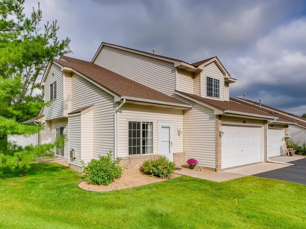
6877 Benton Way
Inver Grove Heights, MN 55076
2 Weeks Ago
Favorites
6877 Benton Way

Favorites
Check Back Soon for Upcoming Availability
| Beds | Baths | Average SF |
|---|---|---|
| 2 Bedrooms 2 Bedrooms 2 Br | 1.5 Baths 1.5 Baths 1.5 Ba | 1,300 SF |
Fees and Policies
The fees below are based on community-supplied data and may exclude additional fees and utilities.
- Parking
-
Garage--
Details
Utilities Included
-
Water
-
Trash Removal
-
Sewer
About This Property
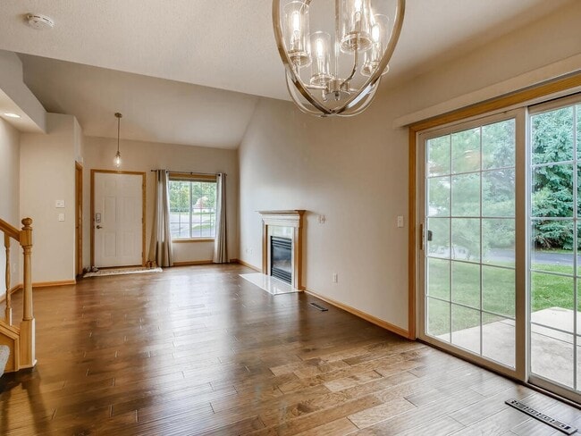
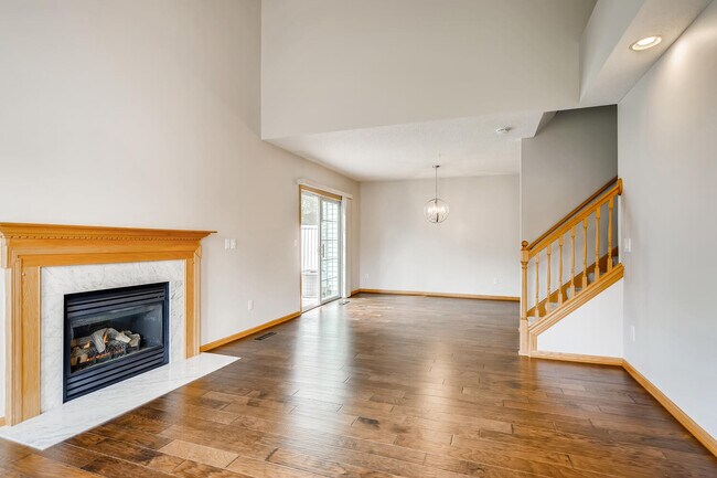
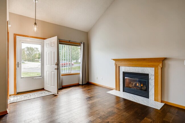
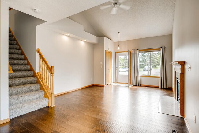
Fully updated and meticulously maintained end unit townhome! Vaulted living room with a gas fireplace and new hardwood flooring welcomes you into this home. Dining area with contemporary light fixture opens to the home's semi-private patio and green space. Perfect for grilling and gardening! Kitchen has been completely renovated to include kitchen cabinets, granite countertops, tile backsplash and SS kitchen appliances. Main floor laundry has updated Washer and Dryer with a storage area. Updated powder room and main bath. Upper level features 2 spacious bedrooms and a loft area, ideal for a home office. Both BRs have WICs. Fresh paint and new carpet throughout entire home. 2 Car Garage with storage shelves. Quiet neighborhood conveniently located close to parks, shopping, restaurants and easy access to Highway 52, Hwy 62 and 494.
6877 Benton Way is a townhome located in Dakota County and the 55076 ZIP Code.
Townhome Features
Washer/Dryer
Air Conditioning
Dishwasher
Loft Layout
- Washer/Dryer
- Air Conditioning
- Smoke Free
- Fireplace
- Dishwasher
- Granite Countertops
- Kitchen
- Carpet
- Dining Room
- Office
- Loft Layout
- Patio
Location
Get Directions
Just off the eastern bank of the Mississippi River, Inver Grove Heights, Minnesota has all the natural beauty expected from the state known for its grassy rolling plains. South of the Twin Cities, Inver Grove Heights is a suburb of Saint Paul. This residential city provides easy access to the surrounding areas thanks to the highway that runs through the city, Highway 52.
Residents of this quiet town enjoy several events and volunteer opportunities that keeps people of Inver Grove Heights connected. There are also many local parks and a community center that provides the community with a variety of recreation opportunities and programs. The new development within the area makes Inver Grove a city with a pleasant mix of both old and new.
Learn more about living in Inver Grove Heights
Amenities
- Washer/Dryer
- Air Conditioning
- Smoke Free
- Fireplace
- Dishwasher
- Granite Countertops
- Kitchen
- Carpet
- Dining Room
- Office
- Loft Layout
- Patio
Expenses
Utilities Included
Water, Trash Removal, Sewer
Included
Education
| Colleges & Universities | Distance | ||
|---|---|---|---|
| Colleges & Universities | Distance | ||
| Drive: | 5 min | 1.7 mi | |
| Drive: | 12 min | 6.8 mi | |
| Drive: | 13 min | 8.8 mi | |
| Drive: | 15 min | 9.3 mi |
6877 Benton Way is within 5 minutes or 1.7 miles from Inver Hills Community College. It is also near Argosy University, Twin Cities and Metropolitan State University.
Transportation options available in Inver Grove Heights include Central Station, located 8.1 miles from 6877 Benton Way. 6877 Benton Way is near Minneapolis-St Paul International/Wold-Chamberlain, located 11.0 miles or 19 minutes away.
| Transit / Subway | Distance | ||
|---|---|---|---|
| Transit / Subway | Distance | ||
| Drive: | 12 min | 8.1 mi | |
| Drive: | 12 min | 8.1 mi | |
| Drive: | 13 min | 8.3 mi | |
| Drive: | 13 min | 8.6 mi | |
| Drive: | 14 min | 8.7 mi |
| Commuter Rail | Distance | ||
|---|---|---|---|
| Commuter Rail | Distance | ||
|
|
Drive: | 13 min | 8.4 mi |
|
|
Drive: | 31 min | 19.0 mi |
|
|
Drive: | 33 min | 24.9 mi |
|
|
Drive: | 43 min | 33.0 mi |
|
|
Drive: | 45 min | 34.7 mi |
| Airports | Distance | ||
|---|---|---|---|
| Airports | Distance | ||
|
Minneapolis-St Paul International/Wold-Chamberlain
|
Drive: | 19 min | 11.0 mi |
Time and distance from 6877 Benton Way.
| Shopping Centers | Distance | ||
|---|---|---|---|
| Shopping Centers | Distance | ||
| Walk: | 18 min | 1.0 mi | |
| Walk: | 20 min | 1.0 mi | |
| Drive: | 3 min | 1.3 mi |
6877 Benton Way has 3 shopping centers within 1.3 miles, which is about a 3-minute walk. The miles and minutes will be for the farthest away property.
| Parks and Recreation | Distance | ||
|---|---|---|---|
| Parks and Recreation | Distance | ||
|
Dodge Nature Center
|
Drive: | 9 min | 5.4 mi |
|
Cherokee Regional Park
|
Drive: | 15 min | 8.3 mi |
|
Highland Park and Golf Course
|
Drive: | 14 min | 9.0 mi |
|
Crosby Farm Regional Park
|
Drive: | 15 min | 9.5 mi |
|
Fort Snelling State Park
|
Drive: | 20 min | 11.4 mi |
6877 Benton Way has 5 parks within 11.4 miles, including Dodge Nature Center, Cherokee Regional Park, and Highland Park and Golf Course.
| Hospitals | Distance | ||
|---|---|---|---|
| Hospitals | Distance | ||
| Drive: | 13 min | 8.7 mi | |
| Drive: | 13 min | 9.0 mi | |
| Drive: | 14 min | 9.1 mi |
6877 Benton Way has 3 hospitals within 9.1 miles, the nearest is St. Joseph's Hospital which is 8.7 miles away and a 13 minute drive.
| Military Bases | Distance | ||
|---|---|---|---|
| Military Bases | Distance | ||
| Drive: | 17 min | 9.9 mi |
6877 Benton Way is 9.9 miles and a 17 minute drive from Fort Snelling Military Reservation.
You May Also Like
Similar Rentals Nearby


What Are Walk Score®, Transit Score®, and Bike Score® Ratings?
Walk Score® measures the walkability of any address. Transit Score® measures access to public transit. Bike Score® measures the bikeability of any address.
What is a Sound Score Rating?
A Sound Score Rating aggregates noise caused by vehicle traffic, airplane traffic and local sources
6877 Benton Way
Inver Grove Heights, MN 55076