
Hanover Soma West
1140 Harrison St,
San Francisco, CA 94103
$3,475 - $8,729 Total Monthly Price
Studio - 3 Beds
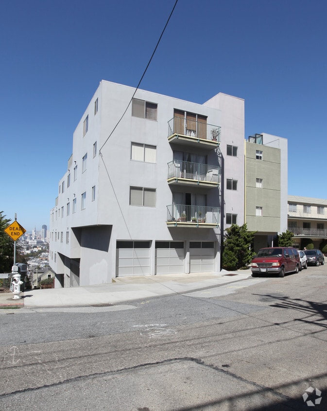
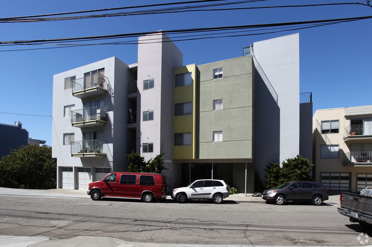

Experience your new home at 66 Corwin St. The 66 Corwin St. location in San Francisco's 94114 Zip code has so much to offer its residents. Make sure you to check out the current floorplan options. A selection of amenities is waiting for you here. Some of these include: high-speed internet access, smoke free options, and security systems. Visit 66 Corwin St today.
66 Corwin St is an apartment community located in San Francisco County and the 94114 ZIP Code. This area is served by the San Francisco Unified School District attendance zone.
Gorgeous Victorian homes, cable cars zipping along the hilly streets, wide sidewalks filled with pedestrians, and an unabashedly unique community – San Francisco's Castro neighborhood is as beautiful as it is unique. Before it became the Castro (named for the landmark theater that opened in 1910), the neighborhood was known as Eureka Valley. The Castro is famous for its active LGBTQIA+ community and is one of San Francisco's most famous neighborhoods.
Castro is located toward the center of the peninsula, slightly south of Market Street and the city center, near the Mission District, Noe Valley, and Twin Peaks. The area is known for its lively entertainment that often spills out into the streets. From art to culture to food, Castro has a multitude of things to discover and explore.
Learn more about living in CastroCompare neighborhood and city base rent averages by bedroom.
| Castro | San Francisco, CA | |
|---|---|---|
| Studio | $2,389 | $2,563 |
| 1 Bedroom | $2,993 | $3,400 |
| 2 Bedrooms | $3,651 | $4,648 |
| 3 Bedrooms | $5,688 | $5,855 |
| Colleges & Universities | Distance | ||
|---|---|---|---|
| Colleges & Universities | Distance | ||
| Drive: | 8 min | 2.4 mi | |
| Drive: | 9 min | 2.6 mi | |
| Drive: | 7 min | 2.7 mi | |
| Drive: | 11 min | 4.0 mi |


Transportation options available in San Francisco include Metro Castro Station/Outbound, located 0.6 mile from 66 Corwin St. 66 Corwin St is near San Francisco International, located 13.4 miles or 25 minutes away, and Metro Oakland International, located 22.2 miles or 37 minutes away.
| Transit / Subway | Distance | ||
|---|---|---|---|
| Transit / Subway | Distance | ||
| Walk: | 10 min | 0.6 mi | |
| Walk: | 13 min | 0.7 mi | |
| Walk: | 14 min | 0.7 mi | |
|
|
Drive: | 4 min | 1.2 mi |
| Drive: | 5 min | 1.3 mi |
| Commuter Rail | Distance | ||
|---|---|---|---|
| Commuter Rail | Distance | ||
| Drive: | 10 min | 3.8 mi | |
| Drive: | 14 min | 5.6 mi | |
| Drive: | 19 min | 10.0 mi | |
| Drive: | 21 min | 13.1 mi | |
|
|
Drive: | 26 min | 13.8 mi |
| Airports | Distance | ||
|---|---|---|---|
| Airports | Distance | ||
|
San Francisco International
|
Drive: | 25 min | 13.4 mi |
|
Metro Oakland International
|
Drive: | 37 min | 22.2 mi |
Scores provided by
Traffic
-Airport
-Businesses
-Scores provided by
HowLoud What is a Sound Score Rating? A Sound Score Rating aggregates noise caused by vehicle traffic, airplane traffic and local sources. How It WorksTime and distance from 66 Corwin St.
| Shopping Centers | Distance | ||
|---|---|---|---|
| Shopping Centers | Distance | ||
| Walk: | 14 min | 0.8 mi | |
| Drive: | 4 min | 1.1 mi |
| Parks and Recreation | Distance | ||
|---|---|---|---|
| Parks and Recreation | Distance | ||
|
Buena Vista Park
|
Drive: | 5 min | 1.6 mi |
|
Randall Museum
|
Drive: | 5 min | 1.7 mi |
|
Conservatory of Flowers
|
Drive: | 7 min | 2.5 mi |
|
California Academy of Sciences
|
Drive: | 10 min | 3.2 mi |
|
Steinhart Aquarium
|
Drive: | 10 min | 3.2 mi |
| Hospitals | Distance | ||
|---|---|---|---|
| Hospitals | Distance | ||
| Drive: | 4 min | 1.4 mi | |
| Drive: | 5 min | 1.7 mi | |
| Drive: | 5 min | 1.8 mi |
| Military Bases | Distance | ||
|---|---|---|---|
| Military Bases | Distance | ||
| Drive: | 15 min | 5.3 mi | |
| Drive: | 16 min | 5.9 mi | |
| Drive: | 20 min | 8.3 mi |
Pets Allowed Fitness Center In Unit Washer & Dryer Walk-In Closets Stainless Steel Appliances Hardwood Floors EV Charging
Pets Allowed Fitness Center In Unit Washer & Dryer Stainless Steel Appliances Business Center Package Service Elevator
What Are Walk Score®, Transit Score®, and Bike Score® Ratings?
Walk Score® measures the walkability of any address. Transit Score® measures access to public transit. Bike Score® measures the bikeability of any address.
What is a Sound Score Rating?
A Sound Score Rating aggregates noise caused by vehicle traffic, airplane traffic and local sources.


