

$1,600
/ Month
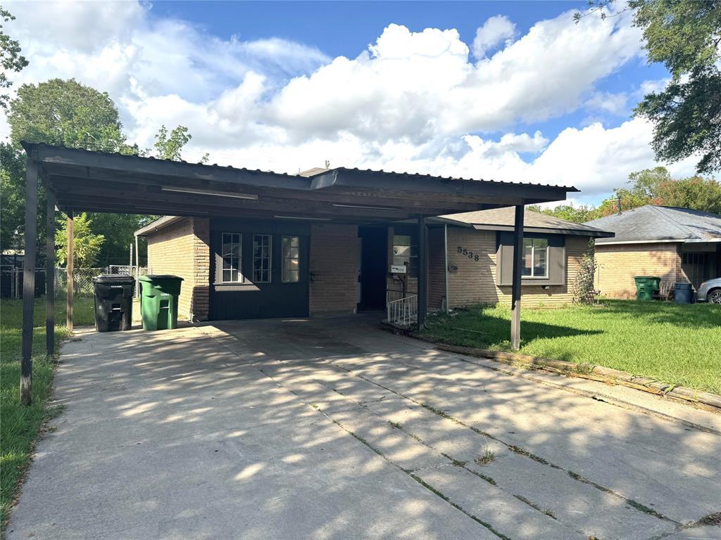
5538 Maywood Dr
Houston, TX 77053
2 Weeks Ago
|
Edit
Favorites
5538 Maywood Dr

Favorites
Check Back Soon for Upcoming Availability
| Beds | Baths | Average SF |
|---|---|---|
| 4 Bedrooms 4 Bedrooms 4 Br | 1.5 Baths 1.5 Baths 1.5 Ba | — |
Fees and Policies
The fees below are based on community-supplied data and may exclude additional fees and utilities.
- One-Time Move-In Fees
-
Application Fee$65
Details
Lease Options
-
12 Months
About This Property
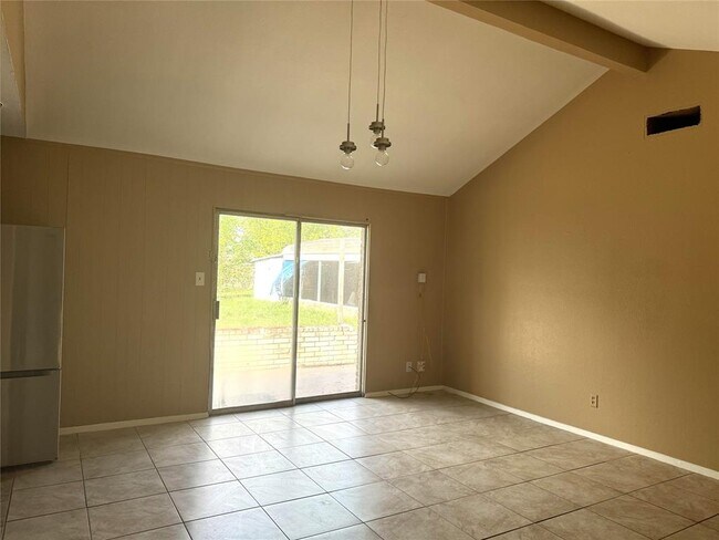
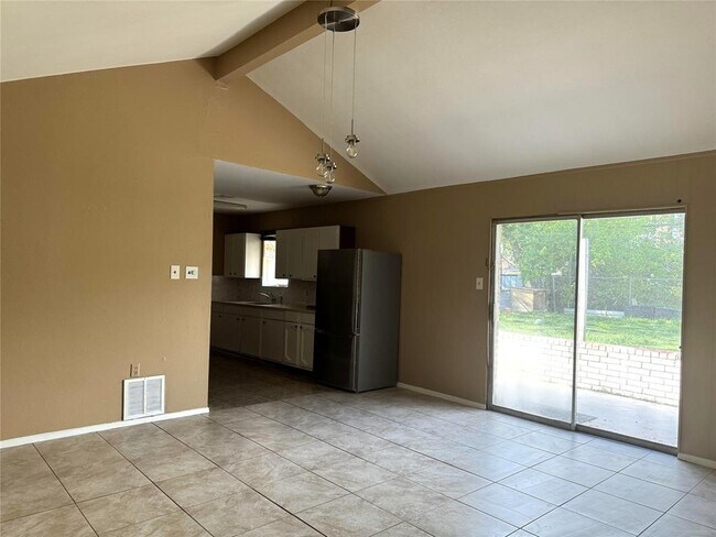
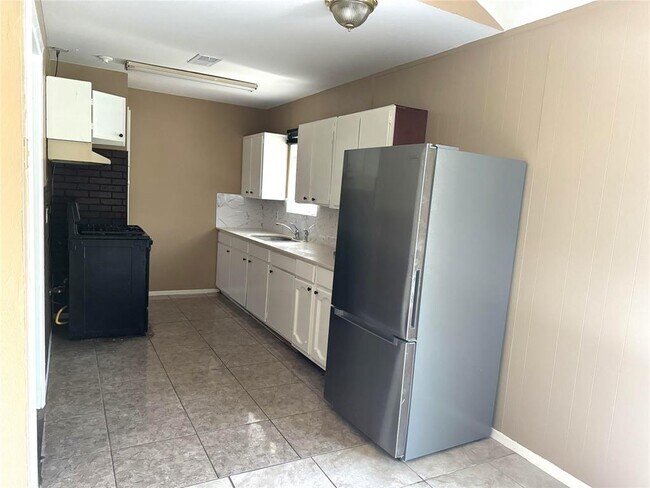
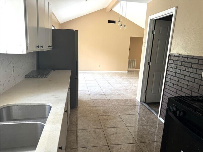
This 4 bedroom, 1.5 bathroom home has tile throughout and includes a brand new refrigerator. Other features include a covered carport and large, fenced-in back yard. Conveniently located near the intersection of Beltway 8 and S. Post Oak Rd. Schedule your private tour today!
5538 Maywood Dr is a house located in Fort Bend County and the 77053 ZIP Code. This area is served by the Fort Bend Independent attendance zone.
House Features
- Smoke Free
Location
Get Directions
Located about 20 miles southwest of Downtown Houston, Fort Bend Houston offers a tight-knit community and a break from the fast pace of city life. The majority of the neighborhood consists of single-story suburban homes, but there’s been an explosion in apartment offerings in this Houston bedroom community. Get a rental near Post Oak Road to stay close to most of the area's shopping and dining options.
Quick, casual restaurants make up Fort Bend Houston's dining scene, and there’s even more variety just over Sam Houston Tollway. During the summer, Blueridge Park, a splash park with water sprays, serves as a popular way to beat the heat. The conveniences of the city are just minutes away, making this a great locale for commuters.
Learn more about living in Fort Bend HoustonBelow are rent ranges for similar nearby apartments
Amenities
- Smoke Free
Education
| Colleges & Universities | Distance | ||
|---|---|---|---|
| Colleges & Universities | Distance | ||
| Drive: | 17 min | 8.8 mi | |
| Drive: | 17 min | 8.9 mi | |
| Drive: | 16 min | 9.2 mi | |
| Drive: | 18 min | 10.2 mi |
5538 Maywood Dr is within 17 minutes or 8.8 miles from Houston Christian University. It is also near Houston Baptist University and UT Health Houston.
Schools


Public Elementary School
Grades PK-5
449 Students
Attendance Zone
Public Middle School
Grades 6-8
835 Students
Attendance Zone
Public Middle & High School
Grades 8-12
1,319 Students
Attendance Zone
Private Elementary & Middle School
Grades PK-8
31 Students
Nearby
Private High School
Grades 9-12
Nearby
School data provided by
 The GreatSchools Rating helps parents compare schools within a state based on a variety of school quality indicators and provides a helpful picture of how effectively each school serves all of its students. Ratings are on a scale of 1 (below average) to 10 (above average) and can include test scores, college readiness, academic progress, advanced courses, equity, discipline and attendance data. We also advise parents to visit schools, consider other information on school performance and programs, and consider family needs as part of the school selection process.
View GreatSchools Rating Methodology
Data provided by GreatSchools.org © 2025. All rights reserved.
View GreatSchools Rating Methodology
Data provided by GreatSchools.org © 2025. All rights reserved.
Transportation options available in Houston include Fannin South, located 8.1 miles from 5538 Maywood Dr. 5538 Maywood Dr is near William P Hobby, located 14.5 miles or 25 minutes away, and George Bush Intcntl/Houston, located 35.0 miles or 47 minutes away.
| Transit / Subway | Distance | ||
|---|---|---|---|
| Transit / Subway | Distance | ||
|
|
Drive: | 14 min | 8.1 mi |
|
|
Drive: | 15 min | 8.7 mi |
|
|
Drive: | 14 min | 8.8 mi |
| Drive: | 16 min | 9.5 mi | |
|
|
Drive: | 17 min | 9.8 mi |
| Commuter Rail | Distance | ||
|---|---|---|---|
| Commuter Rail | Distance | ||
|
|
Drive: | 26 min | 17.7 mi |
| Airports | Distance | ||
|---|---|---|---|
| Airports | Distance | ||
|
William P Hobby
|
Drive: | 25 min | 14.5 mi |
|
George Bush Intcntl/Houston
|
Drive: | 47 min | 35.0 mi |
Time and distance from 5538 Maywood Dr.
| Shopping Centers | Distance | ||
|---|---|---|---|
| Shopping Centers | Distance | ||
| Walk: | 6 min | 0.3 mi | |
| Walk: | 8 min | 0.4 mi | |
| Walk: | 9 min | 0.5 mi |
5538 Maywood Dr has 3 shopping centers within 0.5 mile, which is about a 9-minute walk. The miles and minutes will be for the farthest away property.
| Parks and Recreation | Distance | ||
|---|---|---|---|
| Parks and Recreation | Distance | ||
|
Galveston Island State Park
|
Drive: | 12 min | 6.9 mi |
|
Nature Discovery Center
|
Drive: | 14 min | 7.7 mi |
|
Houston Maritime Museum
|
Drive: | 16 min | 9.3 mi |
|
Club Creek Park and Vietnam Veterans Memorial
|
Drive: | 14 min | 9.8 mi |
|
Lowrey Arboretum
|
Drive: | 19 min | 10.7 mi |
5538 Maywood Dr has 5 parks within 10.7 miles, including Galveston Island State Park, Nature Discovery Center, and Club Creek Park and Vietnam Veterans Memorial.
| Hospitals | Distance | ||
|---|---|---|---|
| Hospitals | Distance | ||
| Drive: | 10 min | 6.4 mi | |
| Drive: | 16 min | 8.6 mi | |
| Drive: | 16 min | 9.3 mi |
5538 Maywood Dr has 3 hospitals within 9.3 miles, the nearest is Hca Houston Healthcare Pearland which is 6.4 miles away and a 10 minute drive.
| Military Bases | Distance | ||
|---|---|---|---|
| Military Bases | Distance | ||
| Drive: | 37 min | 26.7 mi | |
| Drive: | 66 min | 52.2 mi |
5538 Maywood Dr is 26.7 miles from Lyndon B Johnson Space Center, and is convenient to other military bases, including Pelican Spit Military Reservation.
You May Also Like
Similar Rentals Nearby
-
-

-
-
-
-
-
1 / 39

-
-
-


What Are Walk Score®, Transit Score®, and Bike Score® Ratings?
Walk Score® measures the walkability of any address. Transit Score® measures access to public transit. Bike Score® measures the bikeability of any address.
What is a Sound Score Rating?
A Sound Score Rating aggregates noise caused by vehicle traffic, airplane traffic and local sources
5538 Maywood Dr
Houston, TX 77053