

$1,850
/ Month
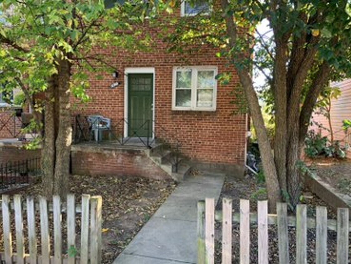
5363 Ames St NE
Washington, DC 20019
2 Weeks Ago
Favorites
5363 Ames St NE

Favorites
Check Back Soon for Upcoming Availability
| Beds | Baths | Average SF |
|---|---|---|
| 2 Bedrooms 2 Bedrooms 2 Br | 1 Bath 1 Bath 1 Ba | 1,420 SF |
About This Property
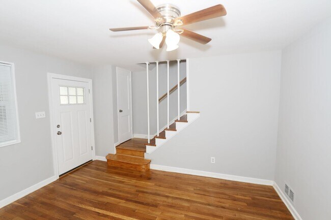
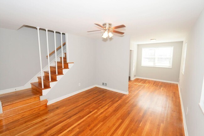
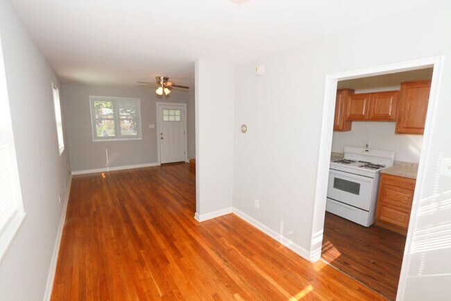
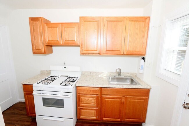
This charming 2 bedroom semi detached townhouse is located in the Deanwood neighborhood. This home features include hardwood floors, central air conditioning, washer/ dryer, ceiling fans, a finished basement and a large private yard. This property is conveniently located on a busline and less than one mile to Benning Rd or Capitol Heights Metro Station. The asking rent is $1850 + utilities. The tenant is responsible for the gas, electric and water utilities. Contact Dakari McAdoo at or email today to schedule a tour Professionally Managed by: KL Associates Inc 1350 Wallach place NW, Washington DC 20009 District law requires that a housing provider state that the housing provider will not refuse to rent a rental unit to a person because the person will provide the rental payment, in whole or in part, through a voucher for rental housing assistance provided by the District or federal government.
5363 Ames St NE is a house located in District of Columbia County and the 20019 ZIP Code. This area is served by the District Of Columbia Public Schools attendance zone.
Location
Get Directions
Grant Park is a hilly, wooded neighborhood located on the north side of Capitol View and directly east of Lincoln Heights. The narrow streets are lined with square, brick houses and a variety of apartment communities. At the east end of the neighborhood, the Watts Branch Playground includes a spray ground, picnic areas, and the Marvin Gaye Recreation Center. Grant Park is an affordable, mostly residential neighborhood located about seven miles southeast of Downtown DC. Residents have easy access to the Tenleytown Metro Station for car-free commutes into the city.
Learn more about living in Grant ParkBelow are rent ranges for similar nearby apartments
Education
| Colleges & Universities | Distance | ||
|---|---|---|---|
| Colleges & Universities | Distance | ||
| Drive: | 9 min | 4.5 mi | |
| Drive: | 10 min | 5.5 mi | |
| Drive: | 10 min | 5.5 mi | |
| Drive: | 11 min | 5.7 mi |
5363 Ames St NE is within 9 minutes or 4.5 miles from Gallaudet University. It is also near Georgetown and Georgetown Law.
Schools


Public Elementary School
Grades PK-5
278 Students
Attendance Zone
Public Middle School
Grades 6-8
351 Students
Attendance Zone
Public High School
Grades 9-12
543 Students
Attendance Zone
Private Elementary & Middle School
Grades K-8
Nearby
Private Elementary School
Grades PK-6
50 Students
Nearby
Private High School
Grades 9-12
Nearby
School data provided by
 The GreatSchools Rating helps parents compare schools within a state based on a variety of school quality indicators and provides a helpful picture of how effectively each school serves all of its students. Ratings are on a scale of 1 (below average) to 10 (above average) and can include test scores, college readiness, academic progress, advanced courses, equity, discipline and attendance data. We also advise parents to visit schools, consider other information on school performance and programs, and consider family needs as part of the school selection process.
View GreatSchools Rating Methodology
Data provided by GreatSchools.org © 2025. All rights reserved.
View GreatSchools Rating Methodology
Data provided by GreatSchools.org © 2025. All rights reserved.
Transportation options available in Washington include Capitol Heights, Blue/Silver Line Center Platform, located 0.8 mile from 5363 Ames St NE. 5363 Ames St NE is near Ronald Reagan Washington Ntl, located 11.0 miles or 20 minutes away, and Baltimore/Washington International Thurgood Marshall, located 28.4 miles or 43 minutes away.
| Transit / Subway | Distance | ||
|---|---|---|---|
| Transit / Subway | Distance | ||
|
Capitol Heights, Blue/Silver Line Center Platform
|
Walk: | 14 min | 0.8 mi |
|
|
Walk: | 15 min | 0.8 mi |
|
|
Drive: | 4 min | 1.9 mi |
|
|
Drive: | 5 min | 2.0 mi |
|
|
Drive: | 5 min | 2.2 mi |
| Commuter Rail | Distance | ||
|---|---|---|---|
| Commuter Rail | Distance | ||
|
|
Drive: | 8 min | 4.8 mi |
|
|
Drive: | 10 min | 4.9 mi |
|
|
Drive: | 13 min | 6.2 mi |
| Drive: | 13 min | 7.5 mi | |
|
|
Drive: | 13 min | 7.5 mi |
| Airports | Distance | ||
|---|---|---|---|
| Airports | Distance | ||
|
Ronald Reagan Washington Ntl
|
Drive: | 20 min | 11.0 mi |
|
Baltimore/Washington International Thurgood Marshall
|
Drive: | 43 min | 28.4 mi |
Time and distance from 5363 Ames St NE.
| Shopping Centers | Distance | ||
|---|---|---|---|
| Shopping Centers | Distance | ||
| Walk: | 5 min | 0.3 mi | |
| Walk: | 15 min | 0.8 mi | |
| Drive: | 4 min | 1.6 mi |
5363 Ames St NE has 3 shopping centers within 1.6 miles, which is about a 4-minute walk. The miles and minutes will be for the farthest away property.
| Parks and Recreation | Distance | ||
|---|---|---|---|
| Parks and Recreation | Distance | ||
|
Fort Dupont Park
|
Drive: | 6 min | 2.2 mi |
|
Kingman and Heritage Island Park
|
Drive: | 5 min | 2.7 mi |
|
Washington Youth Garden
|
Drive: | 7 min | 4.2 mi |
|
Walker Mill Regional Park
|
Drive: | 9 min | 4.6 mi |
|
National Arboretum
|
Drive: | 12 min | 5.0 mi |
5363 Ames St NE has 5 parks within 5.0 miles, including Fort Dupont Park, Kingman and Heritage Island Park, and Walker Mill Regional Park.
| Hospitals | Distance | ||
|---|---|---|---|
| Hospitals | Distance | ||
| Drive: | 8 min | 3.5 mi | |
| Drive: | 15 min | 5.8 mi | |
| Drive: | 15 min | 6.0 mi |
5363 Ames St NE has 3 hospitals within 6.0 miles, the nearest is University of Maryland Prince George's Hospital Center which is 3.5 miles away and a 8 minute drive.
| Military Bases | Distance | ||
|---|---|---|---|
| Military Bases | Distance | ||
| Drive: | 11 min | 5.1 mi | |
| Drive: | 14 min | 7.3 mi |
5363 Ames St NE is 5.1 miles from Washington Navy Yard, and is convenient to other military bases, including Anacostia Naval Station.
You May Also Like
Similar Rentals Nearby


What Are Walk Score®, Transit Score®, and Bike Score® Ratings?
Walk Score® measures the walkability of any address. Transit Score® measures access to public transit. Bike Score® measures the bikeability of any address.
What is a Sound Score Rating?
A Sound Score Rating aggregates noise caused by vehicle traffic, airplane traffic and local sources
5363 Ames St NE
Washington, DC 20019