$2,500
/ Month
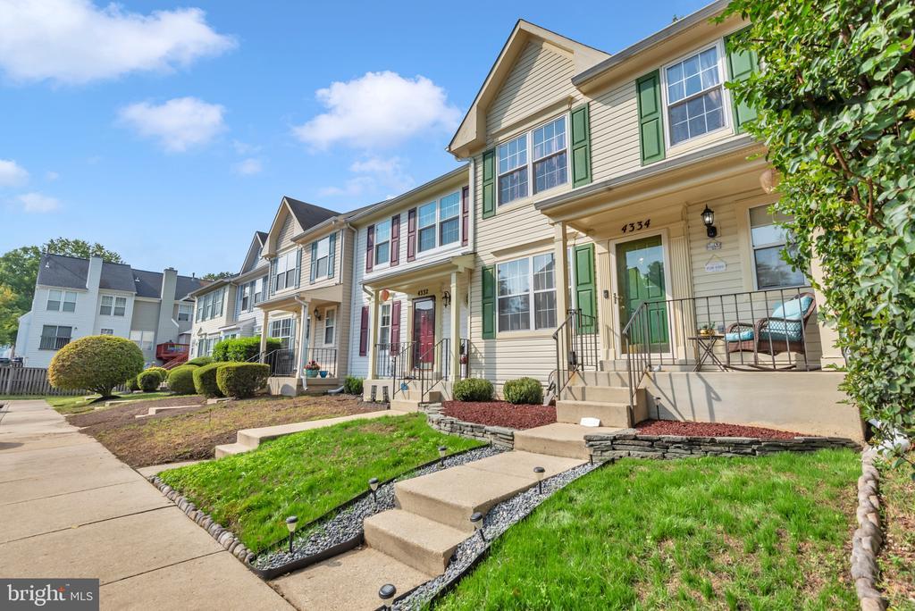
4334 Stockport Way
Upper Marlboro, MD 20772
Today
Favorites
240-270-3833
-
Bedrooms
1
-
Bathrooms
2.5
-
Square Feet
--
-
Available
Available Now
Highlights
- Traditional Floor Plan
- Traditional Architecture
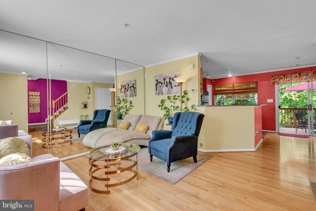
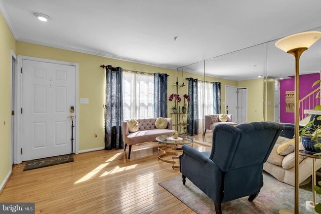
- Wood Flooring
- Stainless Steel Appliances
- Eat-In Kitchen
- Recessed Lighting
4334 Stockport Way

Favorites
About This Home
Available Now
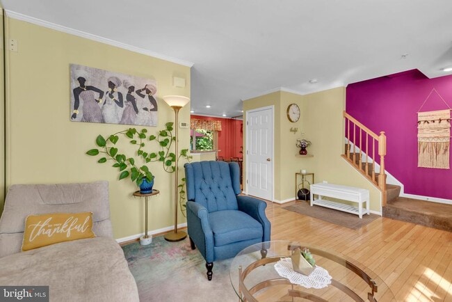
Beautifully Maintained Townhouse in the Sought-After Kings Grant Community – Utilities Included! Enjoy stress-free living in this well-manicured fully furnished townhouse, available for a minimum six-months up to a one year lease with all utilities included in the monthly rent. Offering three full levels of comfort and style, this home is perfect for those seeking both convenience and charm. Upper level presents with a spacious bedroom with a private en-suite bathroom. Main Level provides a Bright open floor plan featuring gleaming hardwood floors, a half bath, and a modern eat-in kitchen with stainless steel appliances and ample counter space. The lower level is Ideal for entertaining or relaxing, complete with a large recreation area, luxurious full spa bathroom, washer and dryer, and a walkout to the private outdoor oasis. Located in the desirable Kings Grant community, this home offers an easy commute to Washington, D.C., I-495, downtown Upper Marlboro, and the Prince George’s County Courthouse. Nearby, you’ll find an abundance of restaurants, shops, and everyday conveniences.
4334 Stockport Way is a townhome located in Prince George's County and the 20772 ZIP Code. This area is served by the Prince George's County Public Schools attendance zone.
* Price shown is base rent. Excludes user-selected optional fees and variable or usage-based fees and required charges due at or prior to move-in or at move-out. Price, availability, fees, and any applicable rent special are subject to change without notice.
* Square footage definitions vary. Displayed square footage is approximate.
Home Details
Home Type
Interior Unit Townhome
Year Built
Built in 1994
Bedrooms and Bathrooms
2.5 Bathrooms
1 Bedroom
Finished Basement
Walk-Out Basement
Laundry in Basement
Rear Basement Entry
Flooring
Wood
Carpet
Laminate
Home Design
Traditional Architecture
Pitched Roof
Shingle Roof
Concrete Perimeter Foundation
Frame Construction
Interior Spaces
Traditional Floor Plan
Recessed Lighting
1,080 Sq Ft Home
Property has 3 Levels
Kitchen
Stainless Steel Appliances
Eat-In Kitchen
Stove
Dishwasher
Disposal
Laundry
Dryer
Washer
Listing and Financial Details
Security Deposit $2,500
6-Month Min and 12-Month Max Lease Term
Available 10/6/25
$45 Application Fee
Assessor Parcel Number 17151720648
The owner pays for all utilities, trash collection, real estate taxes, snow removal
Rent includes electricity, air conditioning, gas, heat, water, snow removal, trash removal
$100 Repair Deductible
No Smoking Allowed
Residential Lease
Lot Details
1,600 Sq Ft Lot
Property is in very good condition
Wood Fence
Back Yard Fenced
Parking
1 Assigned Parking Space
On-Street Parking
Utilities
Forced Air Heating and Cooling System
Natural Gas Water Heater
Community Details
Overview
Kings Grant Subdivision
Association fees include snow removal, trash
Pet Policy
No Pets Allowed
Contact
- Listed by Ralphael Joyner Jr. | TTR Sotheby's International Realty
- Phone Number
- Contact
-
Source
 Bright MLS, Inc.
Copyright © 2025 Bright MLS, Inc.
Location
Get Directions
Amenities
- Dishwasher
- Basement
Popularly known as a government district in Prince George’s County in the state of Maryland, Upper Marlboro offers residents a small-town vibe. Lined with an assortment of businesses, Main Street provides immediate access to the courthouse and county administrative building.
You'll find a combination of busy thoroughfares within the city and a quiet atmosphere in the residential suburbs. To the west of downtown are residential homes on quiet streets with mostly single-family homes, parks, and civic centers. Take a short walk from Main Street to access the Prince George’s County Public system. Aside from the few grocery stores and big-box retailers, the rural nature of the area is the biggest draw for residents. But it also means you might have to head to surrounding areas for more shopping and restaurant options.
Learn more about living in Greater Upper Marlboro
Education
| Colleges & Universities | Distance | ||
|---|---|---|---|
| Colleges & Universities | Distance | ||
| Drive: | 16 min | 6.8 mi | |
| Drive: | 19 min | 9.5 mi | |
| Drive: | 31 min | 17.7 mi | |
| Drive: | 30 min | 18.0 mi |
4334 Stockport Way is within 16 minutes or 6.8 miles from Prince George's Comm. Coll.. It is also near Univ. of Md. Univ. Coll. and Gallaudet University.
Schools


Public Elementary School
Grades PK-5
746 Students
Attendance Zone
Public Middle School
Grades 6-8
873 Students
Attendance Zone
Public High School
Grades 9-12
2,257 Students
Attendance Zone
Private Elementary & Middle School
Grades PK-8
215 Students
Nearby
Private Middle & High School
Grades 6-12
120 Students
Nearby
School data provided by
 The GreatSchools Rating helps parents compare schools within a state based on a variety of school quality indicators and provides a helpful picture of how effectively each school serves all of its students. Ratings are on a scale of 1 (below average) to 10 (above average) and can include test scores, college readiness, academic progress, advanced courses, equity, discipline and attendance data. We also advise parents to visit schools, consider other information on school performance and programs, and consider family needs as part of the school selection process.
View GreatSchools Rating Methodology
Data provided by GreatSchools.org © 2025. All rights reserved.
View GreatSchools Rating Methodology
Data provided by GreatSchools.org © 2025. All rights reserved.
Transportation options available in Upper Marlboro include Morgan Boulevard, located 8.4 miles from 4334 Stockport Way. 4334 Stockport Way is near Ronald Reagan Washington Ntl, located 21.4 miles or 37 minutes away, and Baltimore/Washington International Thurgood Marshall, located 33.6 miles or 52 minutes away.
| Transit / Subway | Distance | ||
|---|---|---|---|
| Transit / Subway | Distance | ||
|
|
Drive: | 18 min | 8.4 mi |
|
|
Drive: | 18 min | 8.9 mi |
|
|
Drive: | 19 min | 9.6 mi |
|
Capitol Heights, Blue/Silver Line Center Platform
|
Drive: | 21 min | 10.3 mi |
|
|
Drive: | 21 min | 12.4 mi |
| Commuter Rail | Distance | ||
|---|---|---|---|
| Commuter Rail | Distance | ||
| Drive: | 24 min | 13.3 mi | |
|
|
Drive: | 24 min | 13.3 mi |
|
|
Drive: | 25 min | 13.6 mi |
|
|
Drive: | 31 min | 16.1 mi |
|
Bowie State Marc Sb
|
Drive: | 30 min | 18.0 mi |
| Airports | Distance | ||
|---|---|---|---|
| Airports | Distance | ||
|
Ronald Reagan Washington Ntl
|
Drive: | 37 min | 21.4 mi |
|
Baltimore/Washington International Thurgood Marshall
|
Drive: | 52 min | 33.6 mi |
Time and distance from 4334 Stockport Way.
| Shopping Centers | Distance | ||
|---|---|---|---|
| Shopping Centers | Distance | ||
| Drive: | 3 min | 1.1 mi | |
| Drive: | 8 min | 3.1 mi | |
| Drive: | 7 min | 3.1 mi |
4334 Stockport Way has 3 shopping centers within 3.1 miles, which is about a 7-minute drive. The miles and minutes will be for the farthest away property.
| Parks and Recreation | Distance | ||
|---|---|---|---|
| Parks and Recreation | Distance | ||
|
School House Pond
|
Drive: | 4 min | 1.9 mi |
|
Cheltenham Wetlands Park
|
Drive: | 8 min | 3.8 mi |
|
Watkins Nature Center
|
Drive: | 13 min | 7.7 mi |
|
Old Maryland Farm
|
Drive: | 13 min | 7.8 mi |
|
Watkins Regional Park
|
Drive: | 18 min | 8.8 mi |
4334 Stockport Way has 5 parks within 8.8 miles, including School House Pond, Cheltenham Wetlands Park, and Watkins Nature Center.
| Hospitals | Distance | ||
|---|---|---|---|
| Hospitals | Distance | ||
| Drive: | 21 min | 11.5 mi |
4334 Stockport Way is 11.5 miles and a 21 minute drive from MedStar Southern Maryland Hospital Center.
| Military Bases | Distance | ||
|---|---|---|---|
| Military Bases | Distance | ||
| Drive: | 18 min | 9.8 mi | |
| Drive: | 28 min | 16.2 mi |
4334 Stockport Way is 9.8 miles from Andrews Airforce Base, and is convenient to other military bases, including Washington Navy Yard.
You May Also Like
Similar Rentals Nearby


What Are Walk Score®, Transit Score®, and Bike Score® Ratings?
Walk Score® measures the walkability of any address. Transit Score® measures access to public transit. Bike Score® measures the bikeability of any address.
What is a Sound Score Rating?
A Sound Score Rating aggregates noise caused by vehicle traffic, airplane traffic and local sources

4334 Stockport Way
Upper Marlboro, MD 20772