
$2,200
/ Month
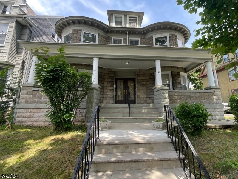
43 Mapes Ave Unit 1R
Newark, NJ 07112
Today
|
Edit
Favorites
973-746-4777
-
Bedrooms
3
-
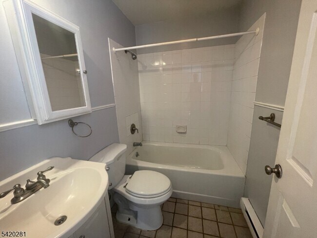
Bathrooms
1.5
-
Square Feet
--
-
Available
Available Now
Highlights
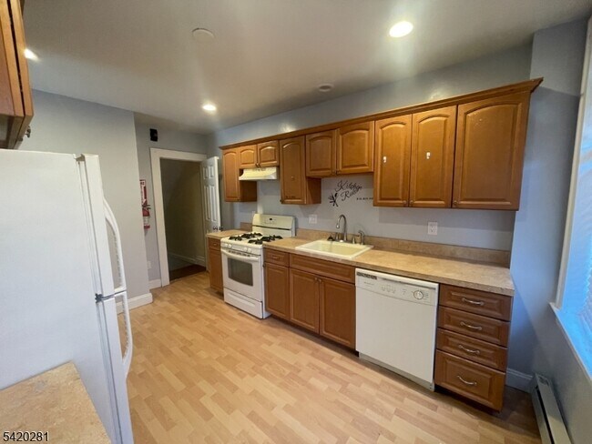
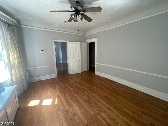
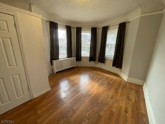
- Wood Flooring
- Main Floor Bedroom
- Porch
- Eat-In Kitchen
- Bathtub with Shower
- Living Room
43 Mapes Ave Unit 1R

Favorites
About This Home
Available Now
Spacious multi-floor 3-bedroom, 1.5-bath apartment offering a unique layout with room to live and grow. This well-maintained unit features generously sized bedrooms, a functional floor plan, and the added convenience of a half bath. The multi-level design provides separation of living spaces, ideal for both privacy and comfort. Conveniently located near major highways, public transportation, shopping, and local amenities. A great opportunity for tenants seeking space and accessibility in the heart of Newark. No pets allowed.
43 Mapes Ave is an apartment community located in Essex County and the 07112 ZIP Code.
* Price shown is base rent. Excludes user-selected optional fees and variable or usage-based fees and required charges due at or prior to move-in or at move-out. Price, availability, fees, and any applicable rent special are subject to change without notice.
* Square footage definitions vary. Displayed square footage is approximate.
Home Details
Year Built
Built in 2022
Basement
Bedroom in Basement
Bedrooms and Bathrooms
Main Floor Bedroom
Bathtub with Shower
1.5 Bathrooms
3 Bedrooms
Home Design
Apartment
Tile
Home Security
Carbon Monoxide Detectors
Fire and Smoke Detector
Interior Spaces
Wood Flooring
Living Room
Kitchen
Eat-In Kitchen
Gas Oven or Range
Dishwasher
Listing and Financial Details
Assessor Parcel Number 1614-03642-0000-00009-0000-
Tenant pays for electric, heat
Lot Details
6,970 Sq Ft Lot
Privacy Fence
Fenced
Outdoor Features
Porch
Parking
Off-Street Parking
1 Parking Space
Utilities
Electric Baseboard Heater
Gas Water Heater
Community Details
Contact
- Listed by JOHN JOHNSON III | GardenStateMLS#NJ
- Phone Number
- Contact
-
Source
Garden State Multiple Listing Service, LLC
Copyright © 2026 Garden State MLS, LLC. All rights reserved. All information provided by the listing agent/broker is deemed reliable but is not guaranteed and should be independently verified.
Location
Get Directions
Located in the South Ward section of Newark, New Jersey, the neighborhood of Weequahic houses a small suburban residential area along with several parks, medical centers, and a number of commercial businesses. On the eastern border of the town stands Weequahic Park, a beautiful natural reserve that remains the centerpiece of the neighborhood and one of Newark's largest parks. There’s a well-maintained jogging path to enjoy and Weequahic Golf Course, the oldest public golf course in the US.
Weequahic is roughly 3.5 miles from the Newark city center, next to other suburban communities such as Hillside, Irvington, and Elizabeth. The neighborhood also benefits from its close proximity to Newark Liberty International Airport, one of the busiest airports in the area.
This is an active area of New Jersey, and the landscape around Weequahic has plenty to offer in terms of dining and retail. Another plus? New York City is just 40 minutes away.
Learn more about living in Weequahic
Amenities
- Dishwasher
- Range
- Refrigerator
- Hardwood Floors
- Tile Floors
- Fenced Lot
- Porch
Education
| Colleges & Universities | Distance | ||
|---|---|---|---|
| Colleges & Universities | Distance | ||
| Drive: | 6 min | 2.7 mi | |
| Drive: | 6 min | 3.3 mi | |
| Drive: | 7 min | 3.3 mi | |
| Drive: | 7 min | 3.4 mi |
43 Mapes Ave Unit 1R is within 6 minutes or 2.7 miles from Essex County College. It is also near N.J. Inst. of Technology and Kean University.
Transportation options available in Newark include Washington Street, located 2.9 miles from 43 Mapes Ave Unit 1R. 43 Mapes Ave Unit 1R is near Newark Liberty International, located 5.2 miles or 8 minutes away, and LaGuardia, located 24.4 miles or 42 minutes away.
| Transit / Subway | Distance | ||
|---|---|---|---|
| Transit / Subway | Distance | ||
|
|
Drive: | 6 min | 2.9 mi |
|
|
Drive: | 6 min | 3.0 mi |
|
|
Drive: | 6 min | 3.2 mi |
|
|
Drive: | 6 min | 3.2 mi |
|
|
Drive: | 7 min | 3.9 mi |
| Commuter Rail | Distance | ||
|---|---|---|---|
| Commuter Rail | Distance | ||
|
|
Drive: | 7 min | 2.2 mi |
|
|
Drive: | 7 min | 2.2 mi |
|
|
Drive: | 6 min | 2.7 mi |
|
|
Drive: | 8 min | 3.0 mi |
|
|
Drive: | 7 min | 3.8 mi |
| Airports | Distance | ||
|---|---|---|---|
| Airports | Distance | ||
|
Newark Liberty International
|
Drive: | 8 min | 5.2 mi |
|
LaGuardia
|
Drive: | 42 min | 24.4 mi |
Getting Around
 What do Walkability, Transit, Drivability, and Bikeability mean?
Walkability measures the walking distance to day-to-day needs.
Transit measures access to public transportation.
Drivability measures congestion, parking availability, and access to major roads.
Bikeability measures the suitability for cycling.
How It Works
What do Walkability, Transit, Drivability, and Bikeability mean?
Walkability measures the walking distance to day-to-day needs.
Transit measures access to public transportation.
Drivability measures congestion, parking availability, and access to major roads.
Bikeability measures the suitability for cycling.
How It Works
Very Walkable
Walkability
80
/ 100
Good Public Transit
Transit
70
/ 100
Moderately Drivable
Drivability
60
/ 100
Fairly Bikeable
Bikeability
50
/ 100
Scores provided by
-
Soundscore™
-
/ 100
Traffic
-Airport
-Businesses
-Scores provided by
HowLoud What is a Sound Score Rating? A Sound Score Rating aggregates noise caused by vehicle traffic, airplane traffic and local sources. How It WorksTime and distance from 43 Mapes Ave Unit 1R.
| Shopping Centers | Distance | ||
|---|---|---|---|
| Shopping Centers | Distance | ||
| Drive: | 3 min | 1.4 mi | |
| Drive: | 4 min | 1.7 mi | |
| Drive: | 5 min | 2.1 mi |
43 Mapes Ave Unit 1R has 3 shopping centers within 2.1 miles, which is about a 5-minute drive. The miles and minutes will be for the farthest away property.
| Parks and Recreation | Distance | ||
|---|---|---|---|
| Parks and Recreation | Distance | ||
|
Newark Museum and Dreyfuss Planetarium
|
Drive: | 6 min | 3.2 mi |
|
Branch Brook Park
|
Drive: | 10 min | 5.0 mi |
|
Kearny Marsh
|
Drive: | 14 min | 6.2 mi |
|
Stephen Gregg Park
|
Drive: | 14 min | 8.5 mi |
|
G. Thomas DiDomenico Park
|
Drive: | 17 min | 10.0 mi |
43 Mapes Ave Unit 1R has 5 parks within 10.0 miles, including Newark Museum and Dreyfuss Planetarium, Branch Brook Park, and Kearny Marsh.
| Hospitals | Distance | ||
|---|---|---|---|
| Hospitals | Distance | ||
| Walk: | 12 min | 0.6 mi | |
| Drive: | 5 min | 2.5 mi | |
| Drive: | 6 min | 3.3 mi |
43 Mapes Ave Unit 1R has 3 hospitals within 3.3 miles, the nearest is Newark Beth Israel Medical Center which is 0.6 mile away and a 12 minute walk.
| Military Bases | Distance | ||
|---|---|---|---|
| Military Bases | Distance | ||
| Drive: | 14 min | 9.0 mi | |
| Drive: | 22 min | 11.9 mi | |
| Drive: | 28 min | 15.8 mi |
43 Mapes Ave Unit 1R has 3 military bases within 15.8 miles, the nearest is Military Ocean Terminal which is 9.0 miles away and a 14 minute drive.
You May Also Like
How do I access Social Services in New Jersey?
Statewide service is free, confidential, multilingual and always open. Three easy ways to reach Social Services in NJ: Dial 2-1-1; text your zip code to 898-211; or chat at https://www.nj211.org
Similar Rentals Nearby
-
-
-
-
-
-
-
-
1 / 28

-
-


What Are Walk Score®, Transit Score®, and Bike Score® Ratings?
Walk Score® measures the walkability of any address. Transit Score® measures access to public transit. Bike Score® measures the bikeability of any address.
What is a Sound Score Rating?
A Sound Score Rating aggregates noise caused by vehicle traffic, airplane traffic and local sources.
43 Mapes Ave
Newark, NJ 07112