
$2,950 / Month
353 Wilder St
Saint Paul, MN 55104
2 Weeks Ago
Favorites
353 Wilder St

Favorites
Check Back Soon for Upcoming Availability
| Beds | Baths | Average SF |
|---|---|---|
| 5 Bedrooms 5 Bedrooms 5 Br | 3 Baths 3 Baths 3 Ba | 3,000 SF |
About This Property
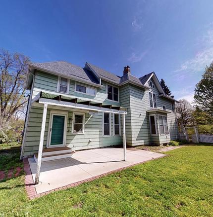
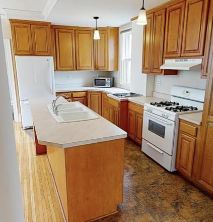
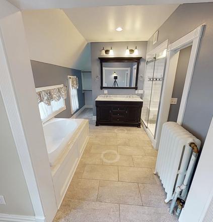
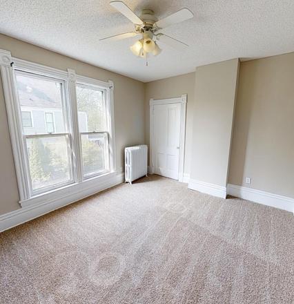
Introducing the perfect home for those seeking convenience, comfort, and a touch of nature - a stunning house with 3 bathrooms, located just a short walk away from the prestigious UST campus. Situated directly across from a serene park, this residence offers a truly idyllic setting for those who appreciate the beauty of the outdoors. Step inside and be greeted by a full kitchen, with lots of room. Adjacent to the kitchen, a beautiful front deck beckons you to relax and unwind, providing the perfect spot for morning coffee or evening conversations with friends. This house has plenty of roomy bedrooms, that also allow you to disappear to your own area. Need a place to entertain or simply enjoy the fresh air? Look no further than the covered pergola patio, ideal for hosting guests or enjoying a quiet moment alone. The spacious yard offers ample room for outdoor activities, ensuring that you can make the most of your new home's surroundings. With plenty of parking and a garage, you'll never have to worry about finding a spot for your vehicle. Don't miss out on this fantastic opportunity to secure a beautiful home in a prime location. Contact us today to schedule a viewing and experience the charm and convenience of this remarkable property. Text Doug
353 Wilder St is a house located in Ramsey County and the 55104 ZIP Code. This area is served by the St. Paul Public attendance zone.
Location
Get Directions
Along the shore of the Mississippi River, Merriam Park West offers riverfront parks, a large golf course, and quaint local restaurants just minutes from downtown Saint Paul, Minnesota. Stop on in at Izzy’s Ice Cream Café, or grab a treat at Black Coffee and Waffle Bar. Local businesses thrive alongside riverfront community spaces like Shadow Falls Park, a picturesque nature preserve.
The University of Saint Thomas resides on the south end of town, and the neighborhood offers a blend of private and public schools, churches, and every day conveniences. Situated just five miles southeast of Minneapolis and seven miles northeast of the Minneapolis-Saint Paul International Airport, this neighborhood is in a premier location for commuting, shopping, dining, and entertainment.
Learn more about living in Merriam Park WestBelow are rent ranges for similar nearby apartments
| Beds | Average Size | Lowest | Typical | Premium |
|---|---|---|---|---|
| Studio Studio Studio | 441 Sq Ft | $640 | $952 | $1,095 |
| 1 Bed 1 Bed 1 Bed | 616-621 Sq Ft | $750 | $1,143 | $1,399 |
| 2 Beds 2 Beds 2 Beds | 889-892 Sq Ft | $1,100 | $1,528 | $1,849 |
| 3 Beds 3 Beds 3 Beds | 1344 Sq Ft | $695 | $1,856 | $3,150 |
| 4 Beds 4 Beds 4 Beds | 1644-1659 Sq Ft | $795 | $1,986 | $6,000 |
Education
| Colleges & Universities | Distance | ||
|---|---|---|---|
| Colleges & Universities | Distance | ||
| Walk: | 17 min | 0.9 mi | |
| Drive: | 4 min | 1.9 mi | |
| Drive: | 4 min | 2.1 mi | |
| Drive: | 7 min | 2.8 mi |
353 Wilder St is within 17 minutes or 0.9 mile from Univ. of St Thomas, St. Paul. It is also near Concordia Univ.-Saint Paul and Macalester College.
Schools


Public Elementary School
Grades PK-5
372 Students
Attendance Zone
Public Elementary School
Grades PK-5
266 Students
Nearby
Public Middle School
Grades 6-8
559 Students
Attendance Zone
Public High School
Grades 9-12
1,691 Students
Attendance Zone
Private Elementary & Middle School
Grades PK-8
186 Students
Nearby
Private Middle & High School
Grades 7-12
Nearby
School data provided by
 The GreatSchools Rating helps parents compare schools within a state based on a variety of school quality indicators and provides a helpful picture of how effectively each school serves all of its students. Ratings are on a scale of 1 (below average) to 10 (above average) and can include test scores, college readiness, academic progress, advanced courses, equity, discipline and attendance data. We also advise parents to visit schools, consider other information on school performance and programs, and consider family needs as part of the school selection process.
View GreatSchools Rating Methodology
Data provided by GreatSchools.org © 2025. All rights reserved.
View GreatSchools Rating Methodology
Data provided by GreatSchools.org © 2025. All rights reserved.
Transportation options available in Saint Paul include Raymond Ave Station, located 1.3 miles from 353 Wilder St. 353 Wilder St is near Minneapolis-St Paul International/Wold-Chamberlain, located 7.2 miles or 17 minutes away.
| Transit / Subway | Distance | ||
|---|---|---|---|
| Transit / Subway | Distance | ||
| Drive: | 4 min | 1.3 mi | |
| Drive: | 3 min | 1.5 mi | |
| Drive: | 4 min | 1.7 mi | |
| Drive: | 4 min | 1.9 mi | |
| Drive: | 5 min | 2.1 mi |
| Commuter Rail | Distance | ||
|---|---|---|---|
| Commuter Rail | Distance | ||
|
|
Drive: | 13 min | 5.8 mi |
|
|
Drive: | 11 min | 6.0 mi |
|
|
Drive: | 21 min | 14.4 mi |
|
|
Drive: | 31 min | 23.2 mi |
|
|
Drive: | 32 min | 24.9 mi |
| Airports | Distance | ||
|---|---|---|---|
| Airports | Distance | ||
|
Minneapolis-St Paul International/Wold-Chamberlain
|
Drive: | 17 min | 7.2 mi |
Time and distance from 353 Wilder St.
| Shopping Centers | Distance | ||
|---|---|---|---|
| Shopping Centers | Distance | ||
| Drive: | 5 min | 2.0 mi | |
| Drive: | 4 min | 2.1 mi | |
| Drive: | 5 min | 2.2 mi |
353 Wilder St has 3 shopping centers within 2.2 miles, which is about a 5-minute drive. The miles and minutes will be for the farthest away property.
| Parks and Recreation | Distance | ||
|---|---|---|---|
| Parks and Recreation | Distance | ||
|
Newell Park
|
Drive: | 3 min | 1.6 mi |
|
Tower Hill Park
|
Drive: | 6 min | 2.1 mi |
|
Macalester College Observatory
|
Drive: | 4 min | 2.1 mi |
|
Brackett Park
|
Drive: | 6 min | 2.1 mi |
|
Longfellow Park
|
Drive: | 7 min | 2.5 mi |
353 Wilder St has 5 parks within 2.5 miles, including Newell Park, Macalester College Observatory, and Brackett Park.
| Hospitals | Distance | ||
|---|---|---|---|
| Hospitals | Distance | ||
| Drive: | 6 min | 3.2 mi | |
| Drive: | 12 min | 4.3 mi | |
| Drive: | 11 min | 5.2 mi |
353 Wilder St has 3 hospitals within 5.2 miles, the nearest is University of Minnesota Medical Center, Fairview which is 3.2 miles away and a 6 minute drive.
| Military Bases | Distance | ||
|---|---|---|---|
| Military Bases | Distance | ||
| Drive: | 15 min | 5.9 mi |
353 Wilder St is 5.9 miles and a 15 minute drive from Fort Snelling Military Reservation.
You May Also Like
Similar Rentals Nearby


What Are Walk Score®, Transit Score®, and Bike Score® Ratings?
Walk Score® measures the walkability of any address. Transit Score® measures access to public transit. Bike Score® measures the bikeability of any address.
What is a Sound Score Rating?
A Sound Score Rating aggregates noise caused by vehicle traffic, airplane traffic and local sources

353 Wilder St
Saint Paul, MN 55104