351 Legion St
351 Legion St,
Brooklyn,
NY
11212
2 Weeks Ago
Favorites
351 Legion St

Favorites
Check Back Soon for Upcoming Availability
Fees and Policies
The fees below are based on community-supplied data and may exclude additional fees and utilities.
- Parking
-
Street--
Details
Lease Options
-
12 Months
About 351 Legion St Brooklyn, NY 11212
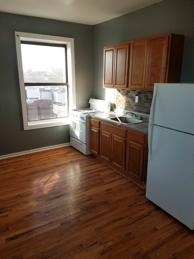
****NO REASONABLE OFFER REFUSED****** This Apartment Features: No Fee! Very Spacious! Hardwood Floors Throughout High Ceilings Large Closets Guarantors Welcomed Good Income+Credit Call/Text for a quicker response
351 Legion St is an apartment community located in Kings County and the 11212 ZIP Code.
Location
Get Directions
Brownsville is a residential neighborhood located about 19 miles southeast of Manhattan in the borough of Brooklyn. Renters appreciate the neighborhood’s affordable housing and accessibility to the city. Several famous people once called Brownsville home, including the Three Stooges. Brownsville boasts walkable streets and excellent access to public transportation. This close-knit community boasts a family-friendly vibe with access to several community parks like Betsy Head Park. Residents live next to the heart of Brooklyn, making Brownsville a great place for commuters.
Learn more about living in BrownsvilleBelow are rent ranges for similar nearby apartments
Education
| Colleges & Universities | Distance | ||
|---|---|---|---|
| Colleges & Universities | Distance | ||
| Drive: | 8 min | 3.0 mi | |
| Drive: | 10 min | 3.9 mi | |
| Drive: | 13 min | 4.3 mi | |
| Drive: | 12 min | 4.5 mi |
351 Legion St is within 8 minutes or 3.0 miles from Medgar Evers College, CUNY. It is also near Brooklyn College and Saint Joseph's Coll, Brooklyn.
Transportation options available in Brooklyn include Saratoga Avenue, located 0.1 mile from 351 Legion St. 351 Legion St is near John F Kennedy International, located 9.8 miles or 16 minutes away, and LaGuardia, located 10.2 miles or 23 minutes away.
| Transit / Subway | Distance | ||
|---|---|---|---|
| Transit / Subway | Distance | ||
|
|
Walk: | 1 min | 0.1 mi |
|
|
Walk: | 9 min | 0.5 mi |
|
|
Walk: | 10 min | 0.5 mi |
|
|
Walk: | 16 min | 0.8 mi |
|
|
Drive: | 5 min | 1.6 mi |
| Commuter Rail | Distance | ||
|---|---|---|---|
| Commuter Rail | Distance | ||
|
|
Drive: | 4 min | 1.9 mi |
|
|
Drive: | 10 min | 3.3 mi |
|
|
Drive: | 13 min | 4.4 mi |
|
|
Drive: | 16 min | 6.8 mi |
|
|
Drive: | 15 min | 7.0 mi |
| Airports | Distance | ||
|---|---|---|---|
| Airports | Distance | ||
|
John F Kennedy International
|
Drive: | 16 min | 9.8 mi |
|
LaGuardia
|
Drive: | 23 min | 10.2 mi |
Time and distance from 351 Legion St.
| Shopping Centers | Distance | ||
|---|---|---|---|
| Shopping Centers | Distance | ||
| Drive: | 4 min | 1.4 mi | |
| Drive: | 4 min | 1.5 mi | |
| Drive: | 6 min | 1.8 mi |
351 Legion St has 3 shopping centers within 1.8 miles, which is about a 6-minute drive. The miles and minutes will be for the farthest away property.
| Parks and Recreation | Distance | ||
|---|---|---|---|
| Parks and Recreation | Distance | ||
|
Betsy Head Memorial Playground
|
Walk: | 7 min | 0.4 mi |
|
St. John's Park
|
Drive: | 6 min | 2.0 mi |
|
Linden Playground
|
Drive: | 5 min | 2.2 mi |
|
Wingate Park
|
Drive: | 8 min | 2.4 mi |
|
Brooklyn Children's Museum
|
Drive: | 8 min | 2.7 mi |
351 Legion St has 5 parks within 2.7 miles, including Betsy Head Memorial Playground, Linden Playground, and St. John's Park.
| Hospitals | Distance | ||
|---|---|---|---|
| Hospitals | Distance | ||
| Walk: | 9 min | 0.5 mi | |
| Drive: | 5 min | 1.8 mi | |
| Drive: | 5 min | 1.8 mi |
351 Legion St has 3 hospitals within 1.8 miles, the nearest is Brookdale Hospital Medical Center which is 0.5 mile away and a 9 minute walk.
| Military Bases | Distance | ||
|---|---|---|---|
| Military Bases | Distance | ||
| Drive: | 14 min | 6.9 mi | |
| Drive: | 22 min | 8.4 mi |
351 Legion St is 6.9 miles from US Navy Reserve, and is convenient to other military bases, including US Coast Guard Heliport.
You May Also Like
Similar Rentals Nearby


What Are Walk Score®, Transit Score®, and Bike Score® Ratings?
Walk Score® measures the walkability of any address. Transit Score® measures access to public transit. Bike Score® measures the bikeability of any address.
What is a Sound Score Rating?
A Sound Score Rating aggregates noise caused by vehicle traffic, airplane traffic and local sources